Winter storm to strike U.S. East, snarling traffic, closing schools

A pedestrian walks through a late season snow storm in New York, U.S., March 21, 2018. REUTERS/Lucas Jackson

(Reuters) – Millions of commuters along the U.S. East Coast will face another round of heavy snow, ice and wind gusts on Wednesday when the fourth major snow storm this month strikes the region, closing schools, grounding flights and halting buses and trains.

The nor’easter storm is on track to dump up to a foot of snow and bring gusts of up to 50 miles per hour (80 kmph) to major cities such as New York, Philadelphia and Boston on Wednesday and into Thursday, the National Weather Service said.

“Significant amounts of snow, sleet and ice will make travel very hazardous or impossible,” the service said in an advisory for New Jersey.

More than 2,000 flights had already been canceled on Tuesday evening at the three major airports that serve New York. Airlines said they were waiving fees to change flights from and to the East Coast.

The storm forced schools across the region including those in Philadelphia and New York, the largest school district in the United States, to cancel classes on Wednesday.

“For everyone’s safety, because it could be such a big storm … we want to be ahead of it,” New York Mayor Bill de Blasio said on Tuesday.

Both Greyhound bus service and Amtrak passenger train service suspended or abbreviated routes for the day. Throughout the East Coast, local bus and train services that millions of people rely on to commute to and from work and school also canceled service on Wednesday.

Widespread power outages were also expected on Wednesday as heavy snow and ice along winds may topple trees and power lines, the service said.

The latest storm comes after storms on March 2, 7 and 12 left at least 9 people dead across the region and more than 2 million homes and businesses without power.

(Reporting by Brendan O’Brien in Milwaukee; Editing by Amrutha Gayathri)

Blizzard bears down on New England, knocking out power

A tractor stands covered in snow during a snowstorm in Huntington, New York, U.S., March 13, 2018. REUTERS/Shannon Stapleton

By Scott Malone

BOSTON (Reuters) – Driving snow enveloped the U.S. Northeast on Tuesday in its third winter storm in two weeks, closing schools, canceling flights and knocking out power to about 140,000 homes and businesses.

The nor’easter was forecast to drop up to 20 inches (51 cm) of snow. It followed two storms that rumbled up the East Coast this month, killing at least nine people and knocking out power to about 2.4 million homes and businesses at their peak.

The storm stretched from New York state to Connecticut, Vermont, New Hampshire, Massachusetts, Rhode Island and Maine. Forecasters warned of blizzard conditions, where high winds make travel dangerous, from coastal Massachusetts through Maine.

“We’re anticipating that we’ll be seeing through the mid- to late morning and probably into midafternoon snowfall rates of 1 to 3 inches per hour (up to 7.6 cm),” said Bob Thompson, a meteorologist with the National Weather Service in Taunton, Massachusetts.

About 140,000 homes and businesses in Massachusetts, Rhode Island and New Jersey lost power as the storm downed trees and power lines.

“As soon as the snow stops and the wind stops blowing, we will be pushing the utilities to give people a sense of when the power will come back on,” Massachusetts Governor Charlie Baker told reporters on Tuesday. “They will move quickly and aggressively to deal with this once the snow stops.”

Schools in Boston and Providence, Rhode Island, were shut on Tuesday, Maine’s state legislature canceled its session, Connecticut Governor Dannel Malloy closed all government offices and the Amtrak passenger rail line halted service between Boston and New York.

More than 1,500 U.S. flights were canceled, according to tracking service FlightAware. The hardest-hit airport was Boston Logan, where about four out of five flights were called off.

Nor’easters are storms that typically bring strong winds from the northeast, and they tend to occur most often and most violently between September and April along the East Coast, the National Oceanic and Atmospheric Administration says.

Some nor’easters carry hurricane-force winds. Winds were expected to reach 65 miles (105 km) per hour, forecasters said.

This storm’s heavy snow could down trees weakened by the last two storms and bring a fresh wave of power outages, officials warned.

Lower tides meant the storm would probably not bring a repeat of the flooding that sent icy water pouring into the streets of Boston during a storm early this month, forecasters and officials said.

(Reporting by Scott Malone; additional reporting by Scott DiSavino in New York; editing by Bill Rigby and Jonathan Oatis)

Travel snarled, power outages as storm bears down on U.S. Northeast

A woman walks during rain while the New York skyline and the One World Trade Center are seen from Exchange Place in New Jersey, U.S., March 7, 2018. REUTERS/Eduardo Munoz

By Jonathan Allen

NEW YORK (Reuters) – The second winter storm within a week crept into New York and surrounding states on Wednesday, with forecasters predicting intensifying snowfall that could snarl the evening commute as thousands remained without power from the last nor’easter.

Between 4 and 12 inches (10 and 30 cm) of snow were forecast for New York City and the surrounding suburbs in New Jersey and Connecticut through to Thursday morning, with wind gusts creating “near-whiteout conditions” for commuters, the National Weather Service said on Wednesday.

The storm will spread with varying degrees of intensity across the Northeast, from western Pennsylvania up into New England, and officials took precautions.

New York’s three major airlines reported a total of 1,431 canceled flights on Wednesday morning, about 40 percent of their normally scheduled flights.

All schools were closed in Philadelphia while schools across the region canceled classes or shortened the school day ahead of the storm, local news media reported. Schools stayed open in New York City.

This week’s storm was not forecast to have the hurricane-strength winds whipped up at times by the storm last week, but forecasters say strong gusts of 60 miles per hour (96.56 km per hour) and accumulated snow will still be enough to knock down more power lines.

Last week’s storm brought major coastal flooding to Massachusetts, killed at least nine people and knocked out power to about 2.4 million homes and businesses in the Northeast.

Some 100,000 homes and businesses in the region remained without power on Wednesday. A nor’easter is an East Coast storm in which winds blow from the northeast.

The governors of New Jersey and Pennsylvania declared states of emergency, giving them access to support from the U.S. government if needed.

The Amtrak passenger train service canceled some Wednesday trains between Washington and Boston, as well as some services in Pennsylvania, New York state and other parts of the Northeast.

The storm got off to an uncertain start in New York City, where the air was damp, and the odd stray snowflake could be spotted, but many early commuters saw no reason to unfurl the umbrellas stashed under their arms.

“I was expecting more than this,” Michelle Boone, 50, said as she waited for a bus to get to her job at a Manhattan homeless shelter. “I’m happy it’s not doing what they said it was going do. This evening could be different, though.”

(Reporting by Jonathan Allen in New York; additional reporting by Scott DiSavino in New York and Barbara Goldberg in Maplewood, New Jersey; editing by Scott Malone and Jonathan Oatis)

Storm to clobber U.S. Midwest with snow, wind and frigid temps

A jogger runs through the rain past the reflecting pool at the Lincoln Memorial in Washington, U.S., February 7, 2018.

By Brendan O’Brien

MILWAUKEE (Reuters) – A storm is expected to clobber Chicago, Detroit and Milwaukee with heavy snow, gusty winds and freezing temperatures that will slow travel for millions of commuters on Thursday evening and Friday.

The storm system that stretches from western Montana across parts of Minnesota, Wisconsin and Illinois and east into southern Michigan will drop as much 12 inches (30 cm) of snow and produce 35 miles per hour (56 kph) winds, the National Weather Service said in several advisories.

“Periods of snow will cause primarily travel difficulties. Be prepared for snow covered roads and limited visibilities,” the service said in an advisory for southern Wisconsin.

Wind chill temperatures were expected to drop below 0 Fahrenheit (-18 C) in many areas across the region on Thursday night and into Friday morning.

United Airlines said on Twitter the storm was expected to impact operations this week and that travel waivers were in effect for areas affected by the snow.

Winter weather across the United States over the last several days has killed several people in accidents in the Midwest since Monday, including six in Iowa, two in Missouri and one in Montana, local media in those states reported.

(Editing by Matthew Mpoke Bigg)

Deadly winter storm delays travel in U.S. Midwest, Northeast

Weather conditions for winter storm 2-6-18 National Weather Service

(Reuters) – A winter storm will dump snow and freezing rain on the U.S. Midwest and the Northeast beginning on Tuesday after it caused several deaths as it snarled highways and spurred the cancellation of hundreds of flights at Chicago’s main airport.

The National Weather Service warned commuters in northern Texas, east through southern Illinois and Indiana, and New York and Massachusetts, to watch for icy road conditions, wind gusts and reduced visibility throughout the day and into Wednesday.

“The ice and snow will result in difficult travel conditions,” the NWS said in an advisory. “Motorists are strongly urged to slow down and allow plenty of time to reach their destinations.”

Winds of 40-miles an hour(65 kph) and as much as 4 inches (10 cm) of snow are expected across the affected regions, with parts of New York and Vermont getting as much as a foot of snow, the NWS said.

The storm was responsible for the death of six people on Monday in crashes throughout Iowa, the Des Moines Register reported.

Two people also died in southwest Missouri and more than 70 others were injured after icy roads caused a high number of crashes, the Springfield News-Leader reported.

At Chicago’s busy O’Hare International Airport, the storm caused the cancellation of more than 460 flights, according to the flight tracking website FlightAware.

(Reporting by Brendan O’Brien in Milwaukee; Editing by Bernadette Baum)

Fierce California winds expected as crews fight to tame wildfire

A home's remains are seen, next to a burnt out truck, after they were destroyed, during a wind-driven wildfire in Ventura.

By Steve Gorman

LOS ANGELES (Reuters) – Crews battling a devastating California wildfire that now ranks as the state’s second-largest on record may face another round of fierce winds on Wednesday after they made progress corralling the flames.

Wind gusts were expected to whip back up to 50 mph (80 kph) on Wednesday evening and into Thursday morning as the so-called Thomas fire burned in the coastal mountains, foothills and canyons of Ventura and Santa Barbara counties northwest of Los Angeles, the National Weather Service said in an advisory.

A firefighter is working on extinguishing the Lilac Fire, a fast moving wildfire in Bonsall.

A firefighter is working on extinguishing the Lilac Fire, a fast moving wildfire in Bonsall.
REUTERS/Mike Blake

On Tuesday, officials scaled back evacuation orders, cut firefighting personnel to 6,800 from about 8,500 and reported improved air quality.

Higher humidity combined with diminished winds and temperatures to ease the firefighters’ job since Sunday. But the region remains “critically dry,” a group of agencies said in a statement.

More than 1,000 homes and other buildings have gone up in flames and about 18,000 structures remained listed as threatened from a late-season firestorm that has kept crews on the defensive for the better part of two weeks.

One firefighter died last Thursday near the town of Fillmore in Ventura County.

Still, fire managers were “cautiously optimistic” that they have gained sufficient ground this week to protect populated areas against the return of the high winds forecast.

By Tuesday night, firefighters had carved containment lines around 55 percent of the blaze’s perimeter – up from 50 percent earlier in the day. But the fire has still spread by several hundred acres a day since the weekend.

In total the fire has scorched 272,000 acres (110,074 hectares) of drought-parched chaparral and brush since igniting on Dec. 4, covering an area equivalent to nearly a third of Rhode Island.

The latest tally makes the Thomas blaze second only in scale in California to the 2003 Cedar fire in San Diego County, which consumed a record 273,246 acres and killed 15 people.

The Thomas fire was initially stoked by hot, dry Santa Ana winds blowing with rare hurricane force from the eastern desert, spreading flames across miles of rugged coastal terrain faster than firefighters could keep up.

(Additional reporting by Brendan O’Brien in Milwaukee; Editing by Hugh Lawson)

One dead as Storm Ophelia batters Ireland

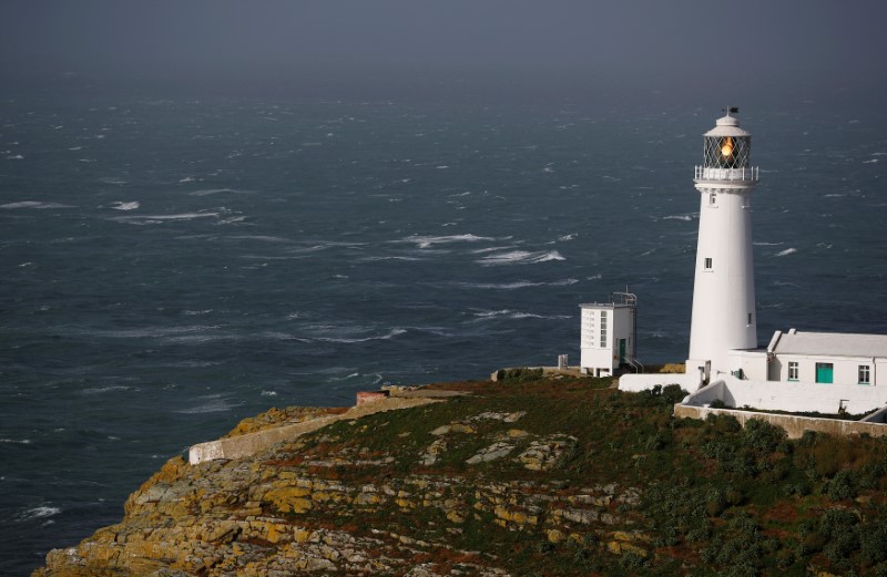
A lighthouse is seen as storm Ophelia approaches South Stack in Anglesey, Wales, Britain, October 16, 2017

By Clodagh Kilcoyne

LAHINCH, Ireland (Reuters) – A woman was killed as Tropical Storm Ophelia battered Ireland’s southern coast on Monday, knocking down trees and power lines and whipping up 10-metre (30-foot) waves.

Over 230,000 homes and businesses were without electricity with more outages expected and almost 150 flights were canceled from Ireland’s two main airports at Dublin and Shannon.

The woman in her 50s was killed by a tree falling on her car in the southeastern county of Waterford, police said. A female passenger in her 70s was injured. Police corrected an earlier report that the victim was in her 20s.

The storm, downgraded from a hurricane overnight, was the worst to hit Ireland in half a century. It made landfall after 10:40 a.m. (0940 GMT), the Irish National Meteorological Service said, with winds as strong as 176 kph (110 mph) hitting the most southerly tip of the country and flooding likely.

“These gusts are life-threatening. Do not be out there,” the chairman of Ireland’s National Emergency Coordination Group, Sean Hogan, said on national broadcaster RTE.

Schools, hospitals and public transport services were closed and the armed forces were sent to bolster flood defences. Photos on social media showed the roof of a stand at Cork City soccer club’s Turner’s Cross stadium had collapsed.

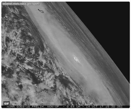
Hurricane Ophelia image captured by NASA is seen in space, October 14, 2017 in this still obtained from social media.

Hurricane Ophelia image captured by NASA is seen in space, October 14, 2017 in this still obtained from social media. NASA SPORT/ via REUTERS

Hurricane force winds are expected in every part of the country, Prime Minister Leo Varadkar said, advising people to stay indoors. The transport minister said it was not safe to drive.

“While the storm in some parts of the country is not yet that bad, it is coming your way,” Varadkar told a news conference.

Britain’s meteorological service put an Amber Weather Warning into effect for Northern Ireland from 1400-2100 GMT, saying the storm posed a danger to life and was likely to cause transport cancellations, power cuts and flying debris.

“Impactful weather” is expected in other western and northern parts of the United Kingdom, it said.

British media are comparing Ophelia to the “Great Storm” of 1987, which subjected parts of the United Kingdom to hurricane strength winds 30 years ago to the day.

The storm is expected to move towards western Scotland overnight.

The Irish government said the storm was likely to be the worst since Hurricane Debbie, which killed 11 in Ireland in 1961.

It is likely to pass close to a west of Ireland golf course owned by U.S. President Donald Trump, who has been planning a wall to protect its greens from coastal erosion.

Similar sized storms in the past have changed the shape of stretches of the Irish coastline, climatologists said.


(Additional reporting and writing by Padraic Halpin and Conor Humphries; Editing by Janet Lawrence and Robin Pomeroy)


Tornadoes, storms kill 11 in U.S. South

A business damaged by tornadoes is seen in Canton, Texas

(Reuters) – Tornadoes ripped through an East Texas county on Saturday evening, killing at least four people and injuring dozens, while high winds, falling trees and floods killed five in neighboring states, according to news reports.

Three tornadoes were confirmed by the U.S. National Weather Service in Canton, a city about 60 miles (95 km) east of Dallas in Van Zandt County.

The winds flipped over cars, snapped trees, destroyed houses and left roads strewn with debris and fallen power lines, according to photographs and video published by the Dallas Morning News.

“We have at least four fatalities,” Canton Mayor Lou Ann Everett said at a news conference on Sunday, adding that number could rise. “The damage was extensive in the affected area. It is heartbreaking and upsetting.” Forty-nine people had been treated for injuries, she said.

Earlier a Canton fire department captain said he believed five people had been killed.

The mayor urged people to stay away from a sprawling flea market known as First Monday Trade Days, as crews tried to clean up debris.

Texas Governor Greg Abbott sent a search and rescue team to the area.

The storms caused floods in neighboring states, killing a 72-year-old woman in southwestern Missouri who was washed away in her car, according to local media reports.

In Arkansas, a woman was killed when a tree fell on her mobile home in DeWitt, and a 10-year-old girl was killed after flood waters swept her away in Springdale, ABC News reported. A fire chief responding to the storm was killed on Sunday in Cleburne County, the county sheriff said

At least two other people reportedly died in storm-related incidents, while two children were missing after their mother’s car was swept from a road by floodwaters in Madison County. As many as 100,000 homes and businesses lost power, and Gov. Asa Hutchinson declared a state of emergency on Sunday night.

In Mississippi, a person was killed after a tree fell on their house in Durant, ABC reported. The governors of Missouri and Oklahoma declared states of emergency.

In the St. Louis area, severe thunderstorms were forecast through Sunday. Some people were told to evacuate and 33 rescues were conducted, mostly in the state’s central and southwestern regions, Missouri Gov. Eric Greitens said.

(Editing by Chris Michaud)

More than 100,000 customers without power in upstate New York

(Reuters) – More than 100,000 customers remained without power in upstate New York on Friday and were told that some outages could last for days after fierce winds toppled power lines and damaged homes and businesses.

Utilities companies reported that nearly 127,000 customers were without power as of 1 a.m. local time as crews continued to access the damage, remove trees and repair power lines after 70 mph (110 kph) wind gusts blew through the area on Wednesday.

“Due to the considerable damage, the companies continue to advise customers to plan for outages extending past the next 24 hours and in some areas may last for multiple days,” power companies NYSEG and RG&E said in a statement.

Homes and business owners throughout the area spent the day on Thursday cleaning up debris and assessing the damage to their structures while crews cleared downed trees and power lines that made some roads impassable.

“I’m alive, my daughter is alive … so I’m happy. Just pick up the pieces and start all over again, that is all I can do,” Twanna Lister said to TWC News in Rochester after a tree smashed through a home she was renting.

The Rochester City School District canceled classes on Friday for its 28,000 students in the hopes that classes will resume on Monday.

(Reporting by Brendan O’Brien in Milwaukee; Editing by Michael Perry)

Storms Bring 100 mph Winds to Pacific Northwest, More on the Way

A storm that hit the Pacific Northwest reportedly featured wind gusts that topped 100 mph.

The Weather Channel reported gusts of 107 mph in Squaw Peak, Oregon, and Mt. Lincoln, California, on Thursday. Sustained winds topped 70 mph in both locations, the report indicated.

There weren’t many reports of major damage, though The Weather Channel report indicated that the storm is believed to have caused a semi truck to flip over just outside of Reno, Nevada.

The Reno Gazette-Journal reported there were about 5,000 power outages during the high winds, though those numbers were reportedly down to fewer than 200 two hours later.

KIRO, a television station in Washington, reported a few scattered power outages but added the local power company said fewer than 800 customers were affected by Thursday night.

The storm came ahead of another that’s expected to dump rain and snow on the region this weekend. The National Weather Service has issued storm warnings in areas off the coasts of Washington, Oregon and northern California, and the storm is expected to continue east.

The Weather Channel forecasts have the heaviest rainfall along the coast of Washington and northern Oregon. It also said that snow is possible in those regions with higher elevations.

The incoming storm is just one of several currently lined up in the northern Pacific, according to AccuWeather forecasts. They indicate a new storm is expected to make landfall every 1-3 days through the middle of the month, though they will all vary in strength and exact trajectory.

The AccuWeather models indicate that two feet of rain could fall on parts of Washington’s coastline through early next week, but most places are not expected to see nearly that amount.

A meteorologist told AccuWeather that the pattern of storms looks to be the work of El Nino, a weather pattern that is marked by part of the Pacific Ocean being warmer than usual. The change has a far-reaching ripple effect that brings atypical weather throughout the world.

A United Nations group has warned this year’s El Nino is looking to be one of the three strongest in the past 65 years and may interact with climate change to create unprecedented effects.