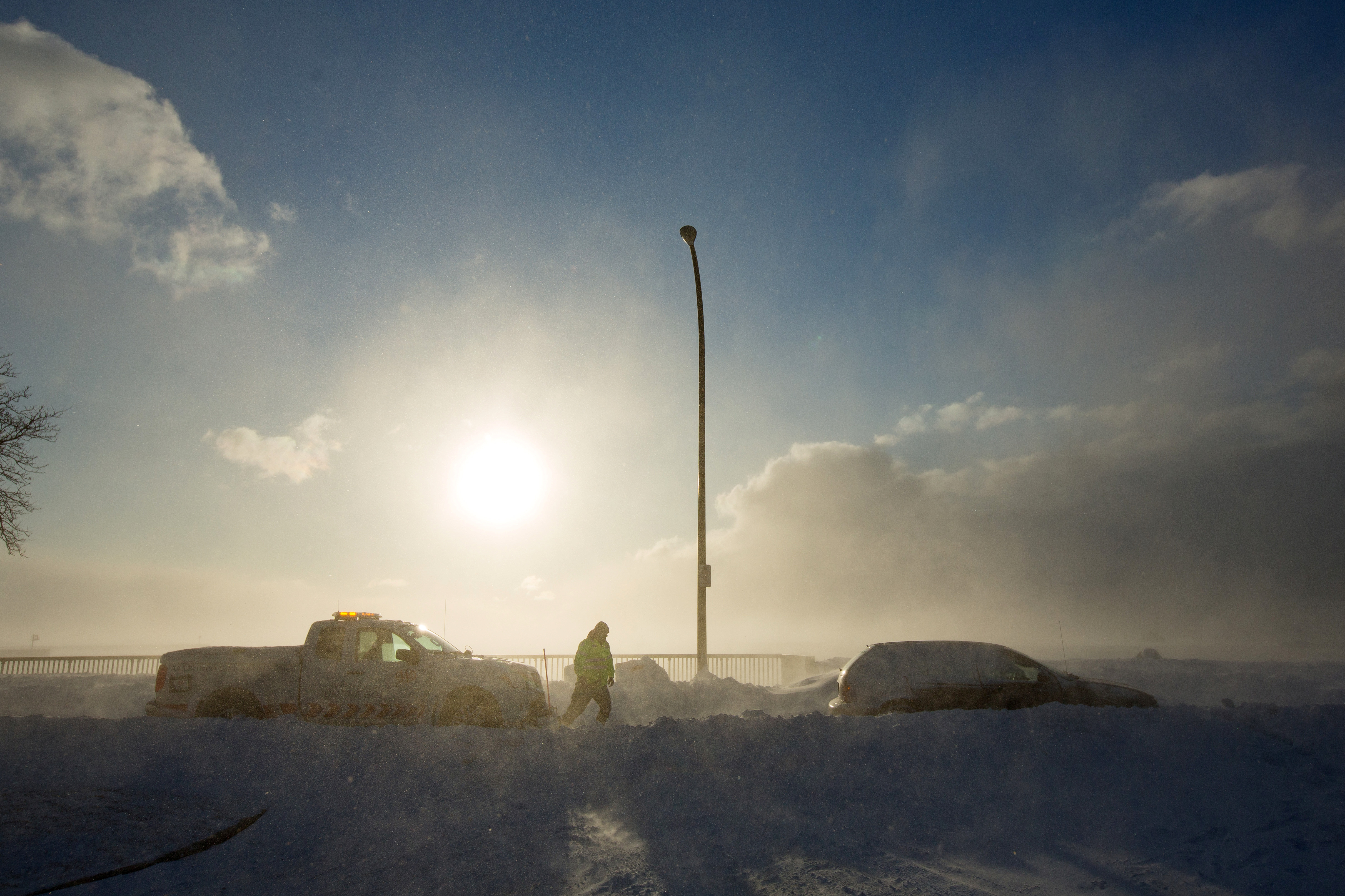
Icy blast begins to ease in U.S. Midwest, Northeast

A worker from AAA aids vehicle trapped in snow during the polar vortex in Buffalo, New York, U.S., January 31, 2019. REUTERS/Lindsay DeDario

By Michael Hirtzer and Gina Cherelus

CHICAGO/NEW YORK (Reuters) – Frigid weather that paralyzed a large swath of the United States this week and caused at least 21 deaths began easing on Friday as an Arctic air mass pulled away, setting the stage for a warmer weekend in the Midwest and the Northeast.

Temperatures from southern New England to the Upper Midwest should reach the mid-40s to low 50s Fahrenheit through the weekend and Monday, forecasters said, after a record-breaking cold snap that stopped mail deliveries in some parts of the Midwest and shuttered schools and businesses.

In Chicago, which experienced temperatures as low as minus 22F (minus 30 Celsius) earlier this week, temperatures of 19F (-7C) on Friday morning felt positively balmy as a measure of normalcy returned to the nation’s third-largest city.

“It feels like summer,” said Dolores Marek, 57, as she got off her commuter train in Chicago wearing a long parka coat as set out on the 1.5 mile-(2.4 km) walk to the local college where she works. “This is much better than it was.”

Meteorologists linked the spell of brutal cold to the so-called polar vortex, a cap of icy air that usually swirls over the North Pole. Changing air currents caused it to slip down through Canada and into the U.S. Midwest this week.

Bryan Jackson, a National Weather Service meteorologist, said the core of the vortex was pulling north into eastern Canada, though residual icy air was still pushing over to the U.S. Northeast.

Temperatures on Friday morning ranged from below zero Fahrenheit to the teens in parts of New York, Pennsylvania, Massachusetts and New Jersey. The Washington D.C. area, which had 20F (minus 7C) temperatures, was under a winter weather advisory until the afternoon as around one inch (2.5 cm) of snowfall accumulated during the morning.

“That cold air that was over the Great Lakes, over the Midwest, has shifted off. Now the high pressure is over Pennsylvania and New York,” Jackson said in a phone interview. “As it moves east, it’ll bring in air from the south and we do expect it to warm up over the weekend.”

Rachel Liao, 29, a student at the New School in New York, said she wished classes had been canceled due to the cold.

A woman takes a selfie in front of a mostly frozen Bryant Park fountain, as record low temperatures spread across the Midwest and Eastern states, in New York City, U.S., January 31, 2019. REUTERS/Brendan McDermid

A woman takes a selfie in front of a mostly frozen Bryant Park fountain, as record low temperatures spread across the Midwest and Eastern states, in New York City, U.S., January 31, 2019. REUTERS/Brendan McDermid

“I just want to stay inside,” Liao, a New York native, said. “I’m not used to this.”

Temperatures in the Upper Midwest, including Illinois, Indiana and Ohio, will reach well above zero F (minus 18C) on Friday, with highs making it into the teens and low 20s.

Even so, parts of Minnesota, Wisconsin, Michigan and Iowa were still experiencing temperatures in the negative single digits, Jackson said.

The lowest temperature recorded early Friday morning was minus 34F (minus 37C) in Stonington, Michigan, according to the National Weather Service.

By Saturday, highs will be in the 30s and even low 40s in the Midwest. The central Plains will be in the low 60s, nearly 20 to 25 degrees above normal, the weather service said.

More than 40 cold-temperature records were broken on Thursday, the coldest morning since the polar vortex moved in late on Tuesday. The mass of Arctic air had clung to a swath of the United States from Iowa and the Dakotas across the Great Lakes region and into Maine for days.

Officials across multiple states linked at least 20 deaths to the deep freeze. The death toll rose after at least nine more people in Chicago were reported to have died from cold-related injuries, according to Stathis Poulakidas, a doctor at the city’s John H. Stroger Jr. Hospital.

Amtrak train services that had been halted since Wednesday in Chicago’s hub resumed on Friday, as did U.S. postal service that was halted or limited in six Midwest states.

Thousands of flights were canceled and delayed earlier in the week, mostly out of Chicago, but on Friday the flight-tracking site FlightAware reported cancellations in the United States down to more than 400.

(Reporting by Rich McKay in Atlanta and Gina Cherelus in New York; Additional reporting by Peter Szekely and Gabriella Borter in New York and Michael Hirtzer in Chicago; Editing by Larry King, Jonathan Oatis and Frances Kerry)

‘Life-and-death’ cold grips eastern, Midwest United States

FILE PHOTO: The U.S. Capitol is seen behind a snow pile in Washington, U.S., January 16, 2019. REUTERS/Yuri Gripas/File Photo

By Rich McKay

(Reuters) – Winter winds brought extreme cold and ice-slicked roads to the Midwestern and Eastern United States on Monday, with the U.S. Martin Luther King Jr. Day holiday and an ongoing government shutdown allowing many to heed official advice to stay indoors.

The arctic blast of frigid air has followed a January storm that dumped more than a foot (30 cm) of snow and sleet across the Northeast, which started melting Sunday.

Pedestrians walk in the rainy day at Time Square in the Manhattan borough of New York City, New York, U.S., January 20, 2019.REUTERS/Jeenah Moon

Pedestrians walk in the rainy day at Time Square in the Manhattan borough of New York City, New York, U.S., January 20, 2019.REUTERS/Jeenah Moon

Temperatures fell to single-digits Fahrenheit (about -20 C) from New York City to Boston and through northern New England and froze melting snow late on Sunday and early Monday, said Marc Chenard at the National Weather Service’s Weather Prediction Center in College Park, Maryland. Winds up to 30 to 40 miles per hour (48-64 kph) added possibly deadly wind chill.

“This is definitely dangerous, life-and-death kind of weather happening,” Chenard said. “Minnesota and Wisconsin will see temperatures in the negative 20s.”

“Boston will be just 3 degrees (Fahrenheit) this morning, with wind chills of minus 12 or more,” he said. “New York City and D.C. will be in that same range, maybe hitting the teens later today. It’ll be record or near-record cold.”

The NWS issued wind-chill advisories and warnings for more than 10 states, from North Dakota and to East Coast metropolitan centers.

High temperatures for Monday are forecast at 17 Fahrenheit (minus 8 Celsius) for New York City and 12 F (minus 11 C) for Boston.

Many Americans had the day off work on Monday, either because of the holiday or because they are among the furloughed federal government workers who find themselves in the longest shutdown in U.S. history, caused by an impasse over funding U.S. President Donald Trump’s plans to build more barriers on the U.S.-Mexico border. [nL1N1ZK05R]

More than 6,000 flights were delayed, mostly in New York and New England, according to FlightAware.com, down from more than 14,000 on Sunday. More than 500 flights were canceled early Monday compared with more than 2,000 Sunday, the website reported.

Tuesday’s weather will be only slightly warmer, Chenard said, with temperatures reaching the low 20s Fahrenheit in the Northeast. By Wednesday, some areas such as Boston will be in the high 30s or low 40s. Washington D.C. temperatures might reach 50 degrees, he said.

But the relatively warmer temperatures won’t last. Another arctic blast is on its way in time for next weekend.

(Reporting by Rich McKay in Atlanta, additional reporting by Jonathan Allen in New York; Editing by Scott Malone and Nick Zieminski)

Worst is over for winter storm that clobbered U.S. Midwest, D.C. and New England

Visitors make their way through snow left by Winter Storm Gia, which paralyzed much of the nation's midsection, at the Lincoln Memorial in Washington, D.C., U.S., January 13, 2019. REUTERS/Mike Theiler

By Rich McKay

(Reuters) – The deadly winter storm that clobbered a swath of the U.S. Midwest and East Coast over the weekend is blowing out to sea but leaves as much as 13 inches of snow in Washington, D.C. and Virginia, and frigid arctic air parked over New England.

All Washington D.C. federal offices would be closed on Monday, but train and bus service in the metro D.C. area would resume after being shut down on Sunday, officials said.

“There’s some digging out to do,” Jim Hayes, a forecaster with the National Weather Service’s Weather Prediction Center in College Park, Maryland, said early Monday.

“In Virginia, D.C. and Maryland, 6-to-12 inches of snow fell with some places getting 13 inches,” he said.

The good news is that around noon on Monday the clouds should start clearing and temperatures will rise into the low 40’s Fahrenheit, Hayes said.

The snowstorm is blamed for the deaths of at least eight people in road accidents across the U.S. Midwest and possibly also the death of an Illinois state police officer who was killed on Saturday during a traffic stop, officials said.

Air traffic at Ronald Reagan National Airport and Dulles International Airport was returning to normal. Early on Monday, fewer than 400 flights were canceled in affected areas and about 1,600 were delayed, according the online flight tracking site FlightAware.

At the height of the storm, more than 1,600 flights were canceled in and out of U.S. airports on Sunday, the bulk of them at Washington’s Reagan and Dulles, the website reported.

Winter storm warnings for millions of Americans in 10 states and Washington, D.C., were being lifted early Monday in a swath of the United States from Colorado to the East Coast, Hayes said.

“But up north it’s going to stay cold,” Hayes said.

Boston temperatures will creep up from the teens (Fahrenheit) into the low 20s. Temperatures in Portland, Maine will top-out at 11 degrees Fahrenheit (minus 12 Celsius) as a core of Arctic air stays parked over New England, Hayes said.

“The worst is in Big Black River, Maine,” said Hayes. “It hit minus 20 (minus 29 Celsius) overnight.”

(Reporting by Rich McKay in Atlanta; Editing by Peter Graff)

Heavy snow hammers U.S. Midwest after holiday weekend

A driver clears the snow off his car during an early season snowfall in the Boston suburb of Medford, Massachusetts, U.S., November 15, 2018. REUTERS/Brian Snyder

(Reuters) – Commuters in Chicago and across the Midwest faced inches of heavy, wet snow as they headed back to work on Monday after the long Thanksgiving holiday weekend, with the storm knocking out power, icing roads and canceling some flights.

The National Weather Service ended blizzard warnings early on Monday in northeast Missouri through the Chicago metropolitan area and northeast into Michigan, but noted strong winds of up to 45 miles per hour (72 kph) would continue to blow around drifts of the snow accumulated overnight.

“Snow will continue to taper off to flurries and then end this morning,” the service’s Chicago office said in a statement, warning drivers to take extra caution on slippery roads in low visibility.

“The drive into work was NASTY,” Diane Pathieu, an ABC7 Chicago news anchor, wrote on Twitter of her pre-dawn commute. “Roads barely plowed, wind blowing snow everywhere. Proceed with caution!”

North of Chicago, the city of Evanston’s police department said in a statement its power had been knocked out by the storm, although it was still able to receive 911 calls.

Dozens of school districts in Illinois, Missouri, Iowa and Kansas canceled classes due to the weather. Chicago public schools were expected to open.

The storm canceled 1,270 flights on Sunday, a busy day for travelers trying to get home after the Thanksgiving weekend.

That included about 900 flights to and from Chicago O’Hare International Airport and Chicago Midway Airport and almost 200 flights at Kansas City International Airport.

On Monday morning, about 500 flights to and from O’Hare had been canceled, about 17 percent of all scheduled flights, according to the FlightAware flight tracking service.

(Reporting by Brendan O’Brien in Milwaukee and Jonathan Allen in New York; Editing by Sunil Nair, Louise Heavens and Frances Kerry)

Expected rains could hinder search for California wildfire victims

Lidia Steineman, who lost her home, prays during a vigil for the lives and community lost to the Camp Fire at the First Christian Church of Chico in Chico, California, November 18, 2018. Noah Berger/Pool via REUTERS

By Jonathan Allen and Nick Carey

(Reuters) – Heavy rains are expected in northern California on Tuesday, raising the risk of mudslides and hindering the search for more victims of the deadliest wildfire in the state’s history as nearly 1,000 people remain listed as missing.

Remains of 79 victims have been recovered since the Camp Fire erupted on Nov. 8 and largely obliterated the Sierra foothills town of Paradise, a community of nearly 27,000 people about 175 miles (280 km) north of San Francisco.

The missing persons list kept by the Butte County Sheriff’s Office still has 993 names on it. That number has fluctuated dramatically over the past week as additional people were reported missing, or as some initially listed as unaccounted for either turn up alive or are identified among the dead.

Sheriff Kory Honea has said some people have been added to the list more than once at times under variant spellings of their names.

As of Monday, the fire has torched more than 151,000 acres (61,100 hectares) of parched scrub and trees, incinerating about 12,000 homes along the way, Cal Fire said.

Containment lines have been built around 70 percent of its perimeter, according to the agency.

Efforts to further suppress the flames were likely to benefit from a storm expected to dump as much as 4 inches (10 cm) of rain north of San Francisco between late Tuesday and Friday, said Patrick Burke, a National Weather Service forecaster.

‘MUDDY, MUSHY MESS’

But heavy showers risk setting off mudslides in newly burned areas while also making it more difficult for forensic teams sifting through cinders and debris for additional human remains.

Colleen Fitzpatrick, founder of the California-based consulting company Identifinders International, said rain would turn the site into a “muddy, mushy mess”, slick with wet ash.

Pathologists from the University of Nevada, Reno worked through the weekend as firefighters peeled back debris, collecting bits of burned bones and photographing everything that might help identify victims.

The risk of mudslides could also increase the misery of the evacuees, some of whom are living in tents or camping out of their cars. Residents who only recently were permitted back in homes that survived the fire may be ordered to evacuate again if they live downslope from badly burned areas.

Intense fire over the slopes of canyons, hills and mountains makes them more prone to landslides, by burning away vegetation and organic material that normally holds soil in place. The fire also creates a hard, waxy surface that tends to repel rather than absorb water.

The result can be a heavy runoff of rainwater mixed with mud, boulders, trees and other debris that flows downhill with tremendous force, said Jason Kean, a research hydrologist for the U.S. Geological Survey.

“Those debris flows have the consistency of wet concrete and move faster than you can run,” he said. “It’s like a flood on steroids … and a big one can take out two-story buildings.”

The number of residents needing temporary shelter was unclear, but as many as 52,000 people were under evacuation orders at the height of the firestorm last week.

Nearly 500 miles south of Paradise near Malibu, west of Los Angeles, at least two inches of rain are expected to fall on a second fire, the Woolsey, which has killed three people. That blaze was 94 percent contained by Monday morning.

The cause of both fires is under investigation, but electric utilities reported localized equipment problems around the time they broke out.

PG&E has said it could face liability that exceeds its insurance coverage if its equipment were found to have caused the Camp Fire.

(Reporting by Brendan O’Brien in Milwaukee; editing by David Stamp)

Storm Michael expected to hit Florida as a hurricane midweek

A satellite image of Tropical Storm Michael taken Monday. NOAA/via REUTERS

By Rich McKay and Jon Herskovitz

(Reuters) – Tropical Storm Michael is on track to hit the Florida Panhandle midweek as a Category 2 hurricane packing 100 miles per hour (160 kmh) or stronger winds, the U.S. National Hurricane Center (NHC) said early Monday in an advisory.

The tropical storm is expected to swell into a Category 1 hurricane as soon as Monday night or early Tuesday as it rolls into the U.S. Gulf of Mexico, with winds of 70 mph, as of 5 a.m. eastern time, forecasters said, just shy of being named a hurricane.

A storm is designated a Category 1 hurricane if it reaches speeds of 74 mph (119 km) or more, and a Category 2 hurricane at 96 mph (154 km) or more on the Saffir-Simpson hurricane wind scale.

Florida Gov. Rick Scott declared a state of emergency in more than 20 counties along the Florida Panhandle and Big Bend on Sunday and has put more than 5,000 National Guard soldiers on alert.

“Our state understands how serious tropical weather is and how devastating any hurricane of tropical storm can be,” Scott said in a statement.

He advised Gulf Coast residents to prepare for possible evacuation orders.

Michael battered parts of Mexico and Cuba with powerful winds and drenching rains on Sunday and into early Monday as it churned in the Caribbean.

The storm moved north on a path between Cozumel in southeastern Mexico and the western tip of Cuba, the Miami-based hurricane center said.

A hurricane watch has been issued from the Alabama-Florida border eastward to the Suwanee River, Florida.

Outer bands from Michael are expected produce as much as 4 inches (10 cm) of rain through Tuesday in the Florida Keys, one of several areas in the state devastated by Hurricane Irma last year.

After hitting Florida, the storm is then forecast to move northeast along the Atlantic Coast and batter the Carolinas, which are still recovering from Hurricane Florence last month. That hurricane killed at least 50 people and caused billions of dollars in damage.

The Commodity Weather Group said on Sunday some oil rigs in the gulf area may be evacuated as a precaution, which may slow down operations but was not likely cause much interruption.

The Gulf of Mexico is home to 17 percent of U.S. crude oil and 5 percent of natural gas output daily, according to the U.S. Energy Information Administration.

More than 45 percent of the nation’s refining capacity is located along the U.S. Gulf Coast, which also is home to 51 percent of total U.S. natural gas processing capability.

(Reporting by Rich McKay in Atlanta and Jon Herskovitz in Austin, Texas; Editing by Raissa Kasolowsky)

Florence-triggered flooding washes into South Carolina

U.S. Army Pfc. Marlen Squire, of the South Carolina National Guard, assists in evacuating local residents from floodwaters as a result of Hurricane Florence in Dongola, South Carolina, U.S. September 24, 2018. Staff Sgt. Jorge Intriago/U.S. Army National Guard/Handout via REUTERS

By Harriet McLeod and Gene Cherry

CHARLESTON, S.C./RALEIGH, N.C. (Reuters) – Thousands of people in the Georgetown, South Carolina area were urged to leave as rivers inundated by Hurricane Florence rainwater threatened on Wednesday to submerge neighborhoods under 10 feet of water.

Georgetown, which sits at the confluence of the Waccamaw, Great Pee Dee and Sampit rivers, was largely spared the initial fury of Florence, which came ashore on Sept. 14 as a Category 1 hurricane and killed 46 people in three states.

But the port city of more than 9,000 people stands in the path of what the National Weather Service says could be significant flooding as water dumped by the storm system drains to the ocean.

Between 6,000 and 8,000 people have been exhorted to leave, but it was not clear how many had done so as of Tuesday evening, said Randy Akers, deputy public information officer for Georgetown County.

Parts of Georgetown could be submerged in up to 10 feet (3 meters) of water in the coming days as the Pee Dee and Waccamaw rivers overrun their banks, the National Weather Service said, adding that the deluge threatened to cut off highways and isolate communities.

“Be very vigilant,” Georgetown County Emergency Management Director Sam Hodge told residents on Facebook. “When you see the water start to rise, that is when it is time to take action.”

High waters surround homes and businesses in the small town of Bucksport, South Carolina, U.S. as rivers continue to rise and flooded areas expand as a result of Hurricane Florence, September 24, 2018. Staff Sgt. Jorge Intriago/U.S. Army National Guard/Handout via REUTERS

High waters surround homes and businesses in the small town of Bucksport, South Carolina, U.S. as rivers continue to rise and flooded areas expand as a result of Hurricane Florence, September 24, 2018. Staff Sgt. Jorge Intriago/U.S. Army National Guard/Handout via REUTERS

COAL ASH POND COULD FLOOD

In neighboring Conway County, the Waccamaw, which was already well above flood stage on Tuesday, could inundate a coal ash pond that holds more than 200,000 tons of toxic ash, according to Santee Cooper, South Carolina’s state-owned electric and water utility.

Santee Cooper said it has removed more than 1 million tons of coal ash, which can contaminate water and harm fish and wildlife, from the site in the past few years.

The Waccamaw was forecast to crest on Thursday at 22 feet in Conway and at 21.2 feet in Georgetown, a representative with the South Carolina Emergency Management Division said.

The potential flood zone encompasses roughly 3,500 homes in Georgetown, 37 miles (60 km) south of Myrtle Beach, and the coastal resort community of Pawleys Island where as many as 8,000 people live, Georgetown County spokeswoman Jackie Broach-Akers said.

Authorities warned residents in harm’s way with recorded telephone messages and home visits. The county opened two emergency shelters on Monday, and hotels in nearby Myrtle Beach were offering discounts to evacuees. Public schools were closed until further notice.

FILE PHOTO: Water from the flooded Waccamaw River surrounds a house in the aftermath of Hurricane Florence now downgraded to a tropical depression in Conway, South Carolina, U.S. September 19, 2018. REUTERS/Randall

FILE PHOTO: Water from the flooded Waccamaw River surrounds a house in the aftermath of Hurricane Florence now downgraded to a tropical depression in Conway, South Carolina, U.S. September 19, 2018. REUTERS/Randall Hill

Crews worked to erect temporary dams on either side of U.S. Highway 17, the main coastal route through the area, and National Guard engineers were installing a floating bridge at Georgetown in case the highway is washed out at the river.

Florence dumped 30 to 40 inches (75 to 100 cm) of rain on Wilmington, North Carolina, alone.

Insured losses from Hurricane Florence will range from $2.8 billion to $5 billion, according to RMS, a risk modeling and analytics firm.

(Additional reporting by Brendan O’Brien in Milwaukee and Dan Whitcomb in Los Angeles; Writing by Dan Whitcomb; Editing by Bill Trott, Leslie Adler and Cynthia Osterman)

Waterways rise in South Carolina, residents told to leave

Flooding is seen in and around Wilmington, North Carolina, U.S., September 19, 2018 in this picture obtained from social media on September 21, 2018. ALAN CRADICK, CAPE FEAR RIVER WATCH/via REUTERS

By Harriet McLeod and Gene Cherry

CHARLESTON, S.C./RALEIGH, N.C. (Reuters) – Authorities urged thousands of people to leave their homes around the city of Georgetown, South Carolina as water dumped by long-departed Hurricane Florence surged down rivers and threatened to bring devastating floods.

Water levels were still rising early on Tuesday, said emergency services there, more than a week after the storm first made landfall on the U.S. Atlantic coast and killed 46 people mostly in North Carolina.

Parts of Georgetown could be submerged in up to 10 feet (3 meters) of floodwaters in the next few days as the Pee Dee and Waccamaw rivers overran their banks, said the National Weather Service.

The deluge threatened to cut off highways and isolate communities, they added.

“If the flood map … shows you are in an affected area, you need to leave,” Georgetown County Sheriff Lane Cribb said on Monday. “Your property can be replaced, but your life can’t.”

Authorities were sending recorded telephone messages to residents in harm’s way and will go door-to-door over the next two days, Georgetown County spokeswoman Jackie Broach-Akers said.

The potential flood zone encompasses some 3,500 homes in Georgetown, 37 miles (60 km) south of Myrtle Beach, and the coastal resort community of Pawleys Island where as many as 8,000 people live, Broach-Akers said.

FLORENCE IMPACT “STILL WITH US”

The county opened two emergency shelters on Monday, and hotels outside the flood zone in nearby Myrtle Beach were offering discounts to evacuees. Public schools will be closed until further notice, Broach-Akers said.

State transportation crews were working to erect temporary dams on either side of U.S. Highway 17, the main coastal route through the area, and National Guard engineers were installing a floating bridge at Georgetown in case the highway is washed out at the river.

The National Weather Service said flooding from Florence would likely persist in coastal parts of the Carolinas for days as the high-water crest of numerous rivers keeps moving downstream toward the ocean.

In North Carolina, Governor Roy Cooper said on Monday that seven rivers in the southeast part of the state were at major flood stages and three others at moderate flood stages.

“Florence is gone but the storm’s devastation is still with us,” Cooper said in a statement.

The storm dumped 30 to 40 inches (75 to 100 cm) of rain on Wilmington, North Carolina, alone after making landfall nearby on Sept. 14. The storm moved northwest before turning back east and becoming a post-tropical cyclone over West Virginia three days later.

Insured losses from Hurricane Florence will range from $2.8 billion to $5 billion, RMS, a risk modeling and analytics firm, said on Monday.

(Reporting by Brendan O’Brien in Milwaukee; Editing by Andrew Heavens)

Rising flood waters from Florence menace Carolinas – kills at least 32

Houses sit in floodwater caused by Hurricane Florence, in this aerial picture, on the outskirts of Lumberton, North Carolina, U.S. September 17, 2018. REUTERS/Jason Miczek

By Ernest Scheyder and Patrick Rucker

WILMINGTON/FAYETTEVILLE, N.C. (Reuters) – Rising flood waters threatened communities across the Carolinas on Tuesday as storm Florence hit the U.S. Northeast with heavy rains and tornadoes after killing at least 32 people.

Widespread flooding has already reached roofs, turned highways into rivers and left thousands to be saved by rescue workers. Waterways are expected to keep rising on Tuesday in places like Fayetteville, North Carolina, a city of 200,000 in the southern part of the state, according to the National Weather Service (NWS).

People take cell phone photos of the flood waters in the aftermath of Hurricane Florence in Fair Bluff, North Carolina, U.S. September 18, 2018. REUTERS/Randall Hill

People take cell phone photos of the flood waters in the aftermath of Hurricane Florence in Fair Bluff, North Carolina, U.S. September 18, 2018. REUTERS/Randall Hill

At least 32 people have been killed since Florence came ashore as a hurricane on Friday, including 25 in North Carolina and six in South Carolina. One person was killed when at least 16 tornadoes developed from Florence on Monday in Virginia, where dozens of buildings were destroyed, the NWS reported.

The dead included a 1-year-old boy swept from his mother as they tried to escape their car amid floodwaters. The woman had driven around barricades to reach a closed road, the sheriff’s office in Union County, near North Carolina’s border with South Carolina, said on Facebook.

“Flooding is still going to be a concern into the weekend and into next week,” NWS meteorologist Hal Austin said, noting there is a chance of rain for the region on Tuesday and Wednesday. “No more water, not even a drop, please.”

With 1,500 roads closed across North Carolina, fire and rescue crews were waiting to go into many areas to assist with structural damage after Florence dumped up to 36 inches (91 cm) of rain on the state since Thursday.

“Road conditions are still changing,” the North Carolina Department of Transportation said on Twitter on Tuesday. “What’s open now may become impassable.”

All told, more than 8 trillion gallons of rain fell on North Carolina, NWS said.

Forecasters warned heavy rains could cause flash flooding in the U.S. Northeast on Tuesday. As much as 6 inches (15 cm) of rain was possible in parts of the region, the NWS said. The storm was now passing through the mid-Atlantic and was about 100 miles (165 km) northwest of Philadelphia, according to the NWS.

It is expected to keep producing heavy rain over Pennsylvania into southern New England.

An aerial picture shows a flooded Interstate 95 (I-95) after Hurricane Florence in Lumberton, North Carolina, U.S. September 17, 2018. REUTERS/Jason Miczek

An aerial picture shows a flooded Interstate 95 (I-95) after Hurricane Florence in Lumberton, North Carolina, U.S. September 17, 2018. REUTERS/Jason Miczek

STRUCTURAL DAMAGE

Thousands of rescues have taken place in the Carolinas and more than 650 people were taken to safety in and around Wilmington, North Carolina, said Barbi Baker, a spokeswoman for New Hanover County. The city took a direct hit when Hurricane Florence came ashore and has been largely cut off since then due to storm surges and flooding from the Cape Fear River.

More than 340,000 customers were without power on Tuesday morning, according to power companies, down from a peak of nearly 1 million outages.

North Carolina had deployed about 2,000 boats and 36 helicopters to help people stranded in floods, the state’s director of emergency management, has said.

The Coast Guard said it had 26 helicopters and 11 aircraft looking for people in trouble.

Property damage from the storm is expected to total at least $17 billion to $22 billion but that forecast could be conservative depending on further flooding, risk management firm Moody’s Analytics said.

A power outage at a wastewater treatment plant in Wilmington caused partially treated sewage water to be released into the Cape Fear River, said Reggie Cheatham, director of the U.S. Environmental Protection Agency’s Office of Emergency Management.

Sewage releases in the Neuse River were reported as well as overflows at several hog “lagoons,” used to store waste from pig farms.

(Additional reporting by Bernie Woodall in Miami; Brendan O’Brien in Milwaukee: Jessica Resnick-Ault and Barbara Goldberg in New York; Anna Mehler Paperny in North Carolina; and Rich McKay in Atlanta; Writing by Bill Trott; Editing by Janet Lawrence)

Storm Florence’s drenching rains kill 23 in the Carolinas

Members of the Coast Guard launch rescue boats into the neighborhood of Mayfair in the flood waters caused by Hurricane Florence in Lumberton, North Carolina, U.S. September 16, 2018. REUTERS/Jason Miczek

By Ernest Scheyder and Patrick Rucker

WILMINGTON/FAYETTEVILLE, N.C. (Reuters) – Deeper flooding loomed in the hours and days ahead from rivers in the Carolinas swollen by Tropical Depression Florence, which has killed 23 people, even if rain-weary residents got a brief glimpse of sunshine on Monday.

The slow-moving storm, a hurricane when it hit the North Carolina coast, has dumped up to 36 inches (91 cm) of rain on the state since Thursday, displacing thousands. The flooding could persist for several weeks in some areas.

The coastal city of Wilmington remained cut off by floodwaters from the Cape Fear River on Monday. Further inland, the same river, running through Fayetteville, a city of 200,000, was expected to reach major flood levels later on Monday, and would not crest until Tuesday.

Florence was headed through Virginia and toward New England and flash flood watches extended from Maryland through New York and southern New England.

In the Carolinas, the National Weather Service continued to warn people the floods were worsening.

“The worst is yet to come,” as river levels rise to historic levels, said Zach Taylor, an NWS meteorologist. “The soil is soaked and can’t absorb any more rain so that water has to go somewhere, unfortunately.”

Major rivers are expected to remain flooded for the next two to three weeks, said Steve Goldstein, National Oceanic and Atmospheric Administration liaison to the U.S. Federal Emergency Management Agency (FEMA).

The death toll from Florence, which came ashore in North Carolina on Friday, rose to 23 on Monday.

The dead included a 1-year-old boy who was swept away from his mother as they tried to escape their car amid floodwaters. The woman had driven around barricades to get on a closed road, the sheriff’s office in Union County, near North Carolina’s border with South Carolina, said on Facebook.

North Carolina officials reported 1,200 road closures, including a stretch of Interstate 95, a major transportation artery running the length of the U.S. East Coast.

About 509,000 homes and businesses were without electricity on Monday in North and South Carolina and surrounding states.

POWER OUTAGES, BLOCKED ROADS

The sun appeared in some areas for the first time in days, allowing some people who had been forced to leave their homes to return home to assess damage.

Eric Tryggeseth, 59, found his home in Leland, North Carolina, without power and with a tree lying in his front yard. He had been evacuated a day before by troops in a truck.

“The floodwaters were rising so I figured I better get out of there,” he said. “I can’t thank the first responders enough.”

There were currently 2,000 federal workers working on storm response, supporting state efforts, said Tom Fargione, FEMA Federal Coordinating Officer, during a press conference.

Sean Adams, 29, a contractor from Leland, said his home suffered only minor damage but he had no idea when power might be restored.

With so many roads in and out of the region flooded, he could not access supplies to help start rebuilding.

“We really can’t get much done right now. It’s getting frustrating,” he said.

The storm killed 17 people in North Carolina, including a mother and child hit by a falling tree, state officials said. Six people died in South Carolina, including four in car accidents and two from carbon monoxide from a portable generator.

(Reporting by Patrick Rucker and Ernest Scheyder; Additional reporting by Bernie Woodall in Miami; Jessica Resnick-Ault and Barbara Goldberg in New York; Anna Mehler Paperny in North Carolina; and Rich McKay in Atlanta; Writing by Bill Trott; Editing by Nick Zieminski and Frances Kerry)