Hurricane Matthew’s threat to Haiti grows, some resist shelters

Families aboard a plane to evacuate them

By Makini Brice and Joseph Guyler Delva

LES CAYES/PORT-AU-PRINCE (Reuters) – Hurricane Matthew edged closer to Haiti on Monday, bringing 130- mile-per-hour (215 kph) winds and torrential rain that could wreak havoc in the Caribbean nation, although some 2,000 people in one coastal town refused to evacuate.

Matthew’s center is expected to near southwestern Haiti and Jamaica on Monday night, the U.S. National Hurricane Center said.

Crawling towards Haiti’s Les Cayes, Jamaica and Cuba at five miles per hour (seven kph), the storm could be just as slow leaving, giving its winds and rain more time to cause damage.

“We are worried about the slow pace of Hurricane Matthew, which will expose Haiti to much more rain, and the country is particularly vulnerable to flooding,” said Ronald Semelfort, director of Haiti’s national meteorology center.

The storm comes at a bad time for Haiti. The poorest country in the Americas is set to hold a long-delayed election next Sunday.

A combination of weak government and precarious living conditions make the country particularly vulnerable to natural disasters. More than 200,000 people were killed when a magnitude 7 earthquake struck in 2010.

“Even in normal times, when we have rain we have flooding that sometimes kills people,” said Semelfort, comparing Matthew to 1963’s Hurricane Flora, which swept away entire villages and killed thousands in Haiti.

RESISTANCE

In Jamaica too, officials were scrambling to protect the vulnerable, as residents boarded up windows and flocked to supermarkets to stock up on food, water, flashlights and beer.

In Cuba, which Matthew is due to reach on Tuesday, evacuation operations were well underway, with people voluntarily moving their belongings into neighbors’ houses or heading to shelters. Some even found cliff-side caves they said were the safest places to ride out storms.

Matthew was about 245 miles (3955 km) south-southeast of Jamaica’s Kingston early on Monday and moving north toward Haiti. The hurricane center ranked it at Category 4 on the five-step Saffir-Simpson scale of hurricane intensity.

In Haiti, some streets were already flooded in Les Cayes, a town of about 70,000 people that was previously ravaged by hurricanes in 1781 and 1788.

But Haitian officials said about 2,000 residents of the La Savane neighborhood of Les Cayes refused to heed government calls to move out of their seaside homes, even though they were just a few miles from where the center of the hurricane is forecast to make landfall.

As the wind died down at night, people remained outside in La Savane, hanging out on porches, playing checkers and dominoes outside, and listening to music.

“The police and local authorities and our evacuation teams have been instructed to do all they can to move those people,” Interior Minister Francois Anick Joseph said.

“They have also been instructed to move them by force if necessary. We have an obligation to protect those peoples lives, even against their will.”

However, the chief of police for the southern region, Luc Pierre, said it was almost impossible to force such a large number of people to leave their homes.

“I would have to arrest all those people and take them to a safe place. This is very difficult,” he said, adding that the power had already gone off in the town.

Poor Haitians are at times reluctant to leave their homes in the face of impending storms, fearing their belongings will be stolen after they leave.

Only a few families had opted to move to a high school in La Savane, designated as a shelter for up to 600 people. It was without electricity and lit only by candlelight.

“There are babies crying here; there is nothing at all,” said Nadja, 32, who was pregnant with her fourth child.

(Additional reporting by Sarah Marsh and Gabriel Stargardter; Writing by Frank Jack Daniel; Editing by Simon Cameron-Moore, Larry King)

Hurricane Matthew strengthens in the Caribbean

By Makini Brice

PORT-AU-PRINCE (Reuters) – Hurricane Matthew strengthened on Friday into the Caribbean’s first major hurricane in four years as it moved towards Jamaica, Haiti and Cuba with winds of up to 115 miles per hour (185 km/h) that could cause devastating damage, forecasters said.

Matthew was about 495 miles (800 km) southeast of Kingston, Jamaica, and the U.S. National Hurricane Center (NHC) designated it as Category 3 on the Saffir-Simpson scale of hurricane intensity.

It is forecast to make landfall as a major storm on Monday on Jamaica’s palm-fringed southern coast, home to tourist resorts as well as the capital and Jamaica’s only oil refinery.

The last major hurricane in the region was Sandy, in 2012.

In Haiti, which has been hard hit by natural disasters in the past, officials said preparation efforts were focussed in the south of the country. Matthew is forecast to skim past the south coast on Monday.

“We will prepare with drinking water for the patients, with medication, with generators for electricity, available vehicles to go look for people at their homes,” said Yves Domercant, the head of the public hospital in Les Cayes in the south.

In Cuba, which has a strong track record of keeping its citizens out of harms way when storms strike, residents of the eastern coastal city of Santiago de Cuba said they were tracking the news closely, although skies were still blue.

“We don’t know yet exactly where it will go, so we’re still waiting to see,” said Marieta Gomez, owner of Hostal Marieta, who was following the storm closely on TV and radio. “We Cubans are well prepared.”

The storm killed one person in St. Vincent and the Grenadines earlier in the week.

(Reporting by Makini Brice, additional reporting by Sarah Marsh in Havana and Vijaykumar Vedala in Bengaluru; Writing by Frank Jack Daniel; editing by Grant McCool)

Storm Julia dumping heavy rains on Georgia and South Carolina coasts

Tropical Storm Julia and other storms lined up in the Atlantic

(Reuters) – Tropical Storm Julia dumped heavy rains along coastal Georgia and South Carolina on Wednesday, weakening as it drifted north along the U.S. Southeast coast, the National Hurricane Center said.

The storm, centered around southeastern Georgia, had gusting winds as strong as 40 mph (65 kph). Heavy rain and high tides threatened low-lying coastal areas prone to flooding, such as parts of Charleston, South Carolina, forecasters said.

“It’s weakening, but it will still continue to produce heavy rain and that is the main hazard that we are concerned with,” said Bob Bright, a meteorologist with the National Weather Service in Charleston.

Julia, the 10th named storm of the 2016 Atlantic hurricane season, is expected to weaken to a tropical depression on Wednesday as it moved north at 7 mph, the Miami-based hurricane center said.

At 8 a.m. (1200 GMT), Julia was about 10 miles (16 km) west of Brunswick, Georgia, the hurricane center said.

Northeast Florida felt the storm’s strong blasts and bands of rain after it came ashore late on Tuesday around Cape Canaveral, forecasters said.

The National Weather Service in Jacksonville, Florida, whose coverage area includes southeastern Georgia, had received reports of toppled trees, but not significant structural damage on Wednesday morning, meteorologist Scott Cordero said.

“We had some pretty good winds associated with it,” he said. “She is starting to lose her tropical characteristics, as she is remaining mainly landlocked.”

(Reporting by Letitia Stein in Tampa, Fla., Brendan O’Brien in Milwaukee, and Swati Verma in Bengaluru; Editing by Andrew Heavens and James Dalgleish)

Lurking Hermine spares much of U.S. East Coast, could regain hurricane strength

Tropical Storm Hermine is pictured off the coast of the U.S. Mid-Atlantic

By Daniel Trotta and Chris Prentice

NEW YORK (Reuters) – Atlantic storm Hermine, which has killed two people, lurked off the middle of the U.S. East Coast late on Sunday while threatening to regain hurricane strength, after having spared the region the brunt of its wind, rain and tidal surge.

Forecasters warned swimmers and boaters to avoid the risk of deadly surf churned up by the storm and stay out of treacherous waters during the Labor Day holiday weekend, when many Americans celebrate the end of summer.

Hermine was still packing maximum sustained surface winds of nearly 70 mph (113 kph) late on Sunday, and forecasters said it  could intensify slightly to reach hurricane strength again, before it starts to dwindle later on Monday.

But for now, its strongest winds were extending outward by about 230 miles (370 km), failing to reach U.S. shores.

Hermine was forecast to bring up to 2 inches (5 cm) of rain to southern New England on Monday, after having hit land in Florida on Friday, and churning up the southeastern seaboard.

Sandbags and tarps cover the entrance to a subway station near Battery Park as New York City prepares for potential flooding as post-tropical storm Hermine stalls off the east coast of the United States

Sandbags and tarps cover the entrance to a subway station near Battery Park as New York City prepares for potential flooding as post-tropical storm Hermine stalls off the east coast of the United States, September 4, 2016. REUTERS/Mark Kauzlarich

Then it merged with a conventional weather front, to be reclassified on Saturday as a post-tropical cyclone.

But Hermine was not expected to make landfall again, said Robbie Berg, an official of the National Hurricane Center.

A tropical storm warning remained in effect Sunday night from the Delaware and New Jersey shores north to New York’s Long Island and beyond to Martha’s Vineyard and Nantucket Island off Massachusetts, but was canceled for New York City, which Berg said appeared largely out of harm’s way.

Potential storm-surge inundation levels of no more than 1 to 3 feet (30 cm to 1 m) were expected in coastal areas.

As the threat to New Jersey waned, Governor Chris Christie ordered Island Beach State Park reopened for Monday, while warning that lingering rip currents and rough surf might still make the ocean unsafe for swimmers.

At 11 p.m. EDT on Sunday, Hermine’s center was about 325 miles (523 km) southeast of Long Island, the eastern tip of New York, the hurricane center said.

It was expected to “meander slowly” off the mid-Atlantic region, moving north-northeast at only 3 mph (5 kph) and stay at least 300 miles (480 km) from shore before beginning to weaken by Monday night, the agency said.

WANING STORM THREAT BEYOND COAST

The storm claimed at least two lives, in Florida and North Carolina, but the widespread power outages and flooding that battered Florida, Georgia and the Carolinas had yet to materialize farther north, where alarming news reports scared many tourists away from the beach on Sunday.

Those who stayed awoke to sunshine, but stronger-than-usual winds and choppy seas.

“It was a little overhyped by the media,” said Andrew Thulin, assistant general manager of Daddy O Hotel Restaurant in the New Jersey township of Long Beach.

“It killed the weekend for everybody down here.”

Officials mindful of the 2012 devastation of Superstorm Sandy took every precaution. Elsewhere in the state coastal roads were reported flooded, and beaches engulfed by the sea.

Hermine became the first hurricane to make landfall in Florida in 11 years, packing winds of 80 mph (129 kph), and knocking out power to 300,000 homes and businesses. Downgraded to a tropical storm within hours, it still packed a wallop.

(Additional reporting by Steve Gorman from Los Angeles and Chris Michaud from New York)

Hermine tears through Florida, raises new Zika fears

Robert Long and his son J.D. watch workers removing downed trees during cleanup operations in the aftermath of Hurricane Hermine in Tallahassee

By Letitia Stein

TAMPA, Fla. (Reuters) – Hurricane Hermine tore a path of destruction across Florida on Friday, knocking out power for 253,000 customers, flooding low-lying areas and raising concerns about the spread of the Zika virus from pools of standing water left behind.

The first hurricane to make landfall in Florida in more than a decade, Hermine came ashore early on Friday near St. Marks, Florida, 20 miles (30 km) south of the capital of Tallahassee, packing winds of 80 mph (130 kph) and churning up a devastating storm surge in coastal areas.

Hermine, which has since been downgraded to a tropical storm, was set to snarl U.S. Labor Day holiday travel as it moves northeast after battering Florida’s $89 billion tourism industry.

The storm center was on the border between Georgia and South Carolina at 2 p.m.(1800 GMT), the National Hurricane Center (NHC) said.

A huge pine tree is shown after falling through a home from the wind and rain damage of Hurricane Hermine in Tallahassee, Florida

A huge pine tree is shown after falling through a home from the wind and rain damage of Hurricane Hermine in Tallahassee, Florida September 2, 2016. REUTERS/Phil Sears REUTERS/Phil Sears


Though sustained winds had weakened to 50 mph (80 kph), the tempest headed toward the Atlantic seaboard on a path where tens of millions of Americans live, causing storm watches and warnings stretching to Rhode Island, NHC said.

It could strengthen again over water and possibly bring up to 15 inches (38 cm) of rain to the southeastern and mid-Atlantic states over the next 48 hours, with heavy rainfall possibly hitting coastal Delaware and New Jersey starting on Saturday night, the center said.

New Jersey, still mindful of the devastation caused by Hurricane Sandy in 2012, was on high alert as emergency officials advised people to prepare for flooding, high winds and a surge of seawater.

New York Governor Andrew Cuomo on Friday activated his state’s emergency operations center and advised emergency officials to stockpile resources, including sandbags and generators.

As it tracks north offshore towards New York, the storm is projected to stall at sea through Wednesday morning, the National Hurricane Center said.

New York Mayor Bill De Blasio said residents should avoid beach waters for fear of life-threatening riptides caused by the lingering storm. “I say that to people who go the beach, I say that to surfers: Don’t even think about it,” De Blasio told a news conference.

WORRIES ABOUT ZIKA

In Florida, concerns over the standing water in which mosquitoes breed intensified as the state battles an outbreak of the Zika virus.

“It is incredibly important that everyone does their part to combat the Zika virus by dumping standing water, no matter how small,” Florida Governor Rick Scott told a news conference, also warning people to look for downed power lines and avoid driving in standing water pools.

There have been 47 cases of Zika in people believed to have contracted the virus through local mosquitoes, according to the Florida Department of Health. Active transmission is thought to be occurring in two small areas around Miami.

As the sun rose on Friday morning on Hudson Beach, just north of Tampa, cars sat askew in flooded roads. Palm fronds, tree branches and garbage cans were scattered about.

Overnight, Pasco County crews rescued more than a dozen people after their homes were flooded.

Richard Jewett, 68, was rescued from his home in New Port Richey, just north of Tampa, around 1:30 a.m. EDT (0530 GMT) as emergency workers carried out a mandatory evacuation.

“The canal started creeping up toward the house and even though it wasn’t high tide it looked like it was coming inside,” Jewett said.

In Cedar Key, an island community in northwest Florida, waters rose more than 9.5 feet (2.9 meters), among the highest surges ever seen, the National Weather Service said.

“This is one of the worst that we have seen in the city in a long time, and unfortunately, it is not over yet,” St. Petersburg, Florida, Mayor Rick Kriseman told reporters.

(Additional reporting by Zachary Fagenson in Hudson Beach, Fla., Brendan O’Brien in Milwaukee, Laila Kearney in New York and Jon Herskovitz in Austin; Editing by Daniel Trotta and Cynthia Osterman)

Hurricane warning issued for parts of Florida; Madeline weakens

A city worker fills sandbags to help residents prepare for an expected tropical storm in Gulfport, Florida

TAMPA BAY, Fla. (Reuters) – Forecasters and public officials urged Floridians to prepare for potentially catastrophic flooding and damaging winds as Tropical Storm Hermine was expected to become a hurricane by the time it reached Florida’s northern Gulf Coast on Thursday.

A hurricane warning was in effect for the Florida panhandle from the Suwannee River to Mexico Beach as the strengthening storm was expected to sweep across northern parts of the state and then northeast along the Atlantic Coast, the National Hurricane Center said in an advisory.

The forecast of rough weather prompted Florida Governor Rick Scott to declare an emergency on Wednesday as many school districts along the Gulf Coast canceled after-school activities and ordered students to stay home on Thursday.

Cities such as Tallahassee and Orlando were offering sandbags to residents to protect homes and businesses from flooding caused by the up to 10 inches (25 cm) of rain as heavy rains were already pounding parts of the state and were expected through Friday.

“There is a danger of life-threatening inundation,” said the center’s advisory that noted the possibility of as much as 20 inches (20 cm) of rain to fall in some isolated areas and life-threatening flash flooding.

The storm, packing winds of 60 mph (95 kmh) with higher gusts, was expected to get stronger by the time it reach landfall, making outside preparations difficult or dangerous, the center said.

“Heavy rainfall and strong winds will make driving dangerous. Even after the storm passes, citizens should avoid unnecessary travel to allow first responders and road clearing crews to quickly respond to emergency needs,” the City of Tallahassee said in an alert to residents.

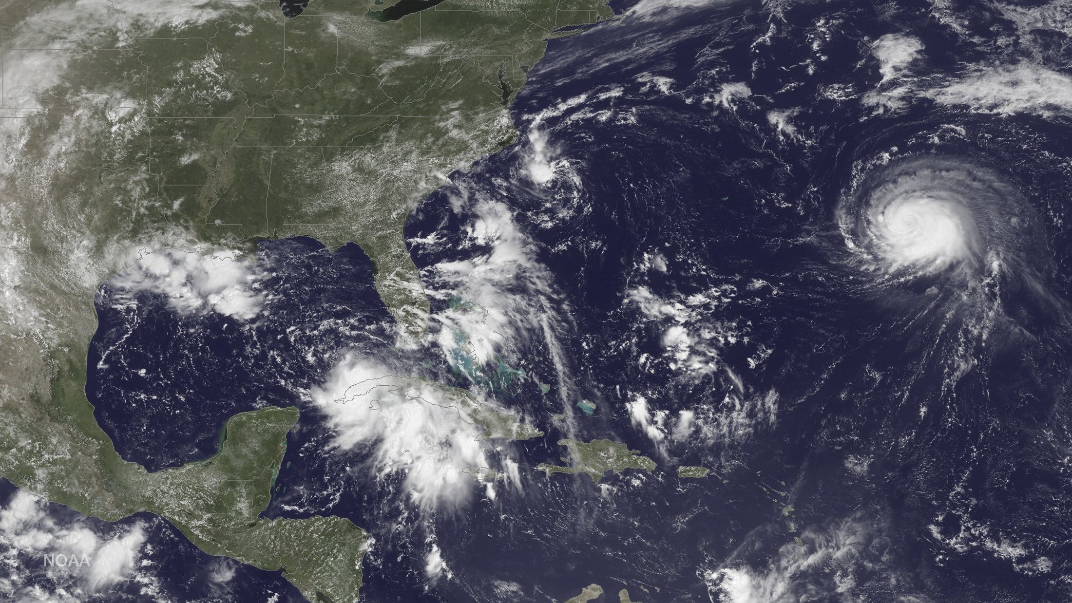
Three storm systems are shown (L TO R) Tropical Depression Nine to the southeast of Florida, Tropical Depression Eight just off the coast of the Carolinas and Hurricane Gaston in the central Atlantic Ocean are shown in this GOES East satellite image captured August 29, 2016. NOAA/handout via REUTERS

Three storm systems are shown (L TO R) Tropical Depression Nine to the southeast of Florida, Tropical Depression Eight just off the coast of the Carolinas and Hurricane Gaston in the central Atlantic Ocean are shown in this GOES East satellite image captured August 29, 2016. NOAA/handout via REUTERS

On its current path, the system would also dump as much as 10 inches (25 cm) of rain on coastal areas of Georgia, which was under a tropical storm watch, and the Carolinas.

A tropical storm warning was also issued for the U.S. east coast from Marineland, Florida to South Santee River, South Carolina, the Miami-based weather forecaster said.

U.S. oil and gas producers in the east of the Gulf of Mexico removed workers from 10 offshore platforms, moved drilling rigs and shut some output because of the storm.

The hurricane center also said in an advisory that the center of Hurricane Gaston will move near the Azores on Friday.

Meantime, Hurricane Madeline weakened to a tropical storm as it passed south of Hawaii’s Big Island, where officials opened shelters and closed offices, schools and roads on Wednesday.

The tropical storm, before it moves westward out of reach of Hawaii, was expected to dump as much as 15 inches (40 cm) of rain on parts of the Big Island, according to the National Weather Service.

Hurricane Lester, currently a major Category 4 storm, could affect Hawaii over the weekend.

Hawaii Governor David Ige signed an emergency proclamation that runs through Sept. 9, freeing up state resources.

(Reporting by Brendan O’Brien in Milwaukee; Editing by Toby Chopra)

Alex gusts into first January hurricane in 78 years

TAMPA, Fla. (Reuters) – Hurricane Alex blasted into the record books on Thursday as the first Atlantic hurricane to form during the month of January in more than three-quarters of a century, U.S. weather forecasters said.

The storm, with wind gusts up to 85 miles an hour, was expected to bear down on the Azores islands off the coast of Portugal on Friday, according to the National Hurricane Center in Miami. It did not pose a threat to the United States.

Local authorities issued a hurricane warning for five islands in the central Azores, which could see flash flooding, mudslides and storm surge, said NHC spokesman Dennis Feltgen.

Alex was rated a “Category 1” hurricane, which is the lowest rating on the five-tier Saffir-Simpson hurricane wind scale.

Only two other hurricanes have appeared in January since forecasters began keeping records in 1851, Feltgen said. Hurricane Alice started in December and carried into January in 1955. The last time a hurricane formed in January was 1938.

Still, the early hurricane does not necessarily portend an unusually active storm period during the Atlantic hurricane season from June through November, Feltgen said. That forecast will be determined by weather conditions not yet seen.

“The good news is that even though we have got a hurricane in January, that is not a harbinger of what the 2016 hurricane season will be like,” he said. “It is no reflection.”

(Reporting by Letitia Stein; Editing by Alan Crosby)

Dangerous Joaquin Now a Category 4 Hurricane

Hurricane Joaquin intensified to an extremely dangerous Category 4 storm Thursday afternoon, and continues to hammer the central Bahamas with hurricane-force winds, storm surge flooding and torrential rain.

The most severe flooding reported so far was on Acklins island, where power went off overnight and phones were down. Some of the roughly 565 people who live there were trapped in their homes. Capt. Stephen Russell, the director of the Bahamas National Emergency Management Agency.Russell said.

Virginia, North Carolina and New Jersey were the latest to declare a state of emergency, warning residents that the severe weather already predicted could be significantly worse if Joaquin veers northwestward. East coast states are alerting residents to prepare as potentially historic rainfall and flooding is set to create havoc into the weekend whether or not Hurricane Joaquin makes U.S. Landfall.  

With the Category 4 hurricane passing close to the islands at a relatively slow speed, a catastrophic situation may unfold there with a prolonged period of intense hurricane conditions. Intense flooding and storm surge is expected to continue.  

Hurricane Joaquin Threatens U.S. East Coast and Bahamas

Tropical Storm Joaquin was upgraded to a Category 1 Hurricane early this morning as it bears in on the Bahamas.  Forecasted to become a Category 3 Hurricane with wind gusts up to 115 mph by Saturday. Winds are now sustained at 80 mph and will hit the Bahamas by early Sunday. Hurricane watches and warnings have been issued.

More than 10,000 people live on the Bahamian islands and should experience tropical storm-like winds Wednesday and hurricane conditions by noon Thursday, the U.S. National Hurricane Center said.

Five to 15 inches of rain could fall. Dangerous storm surges 4 feet above normal tides are also expected.  

“Preparations to protect life and property should be rushed to completion,” the hurricane center said about the Bahamas on Wednesday.

Hurricane Joaquin is the 2015 Atlantic season’s third hurricane. Residents along the East Coast of the U.S. should pay close attention to the forecast now through this weekend. It is a particularly difficult forecast that hinges on the behavior of several different atmospheric features over North America and the North Atlantic Ocean.