Tropical storm nears northern Bahamas, complicating Dorian relief

By Zach Fagenson

NASSAU (Reuters) – The leading edge of a potential tropical storm brought rain and wind to the Bahamas early Friday, complicating the search for 1,300 people missing in the wake of the worst hurricane to ever hit the island nation and efforts to bring relief to survivors.

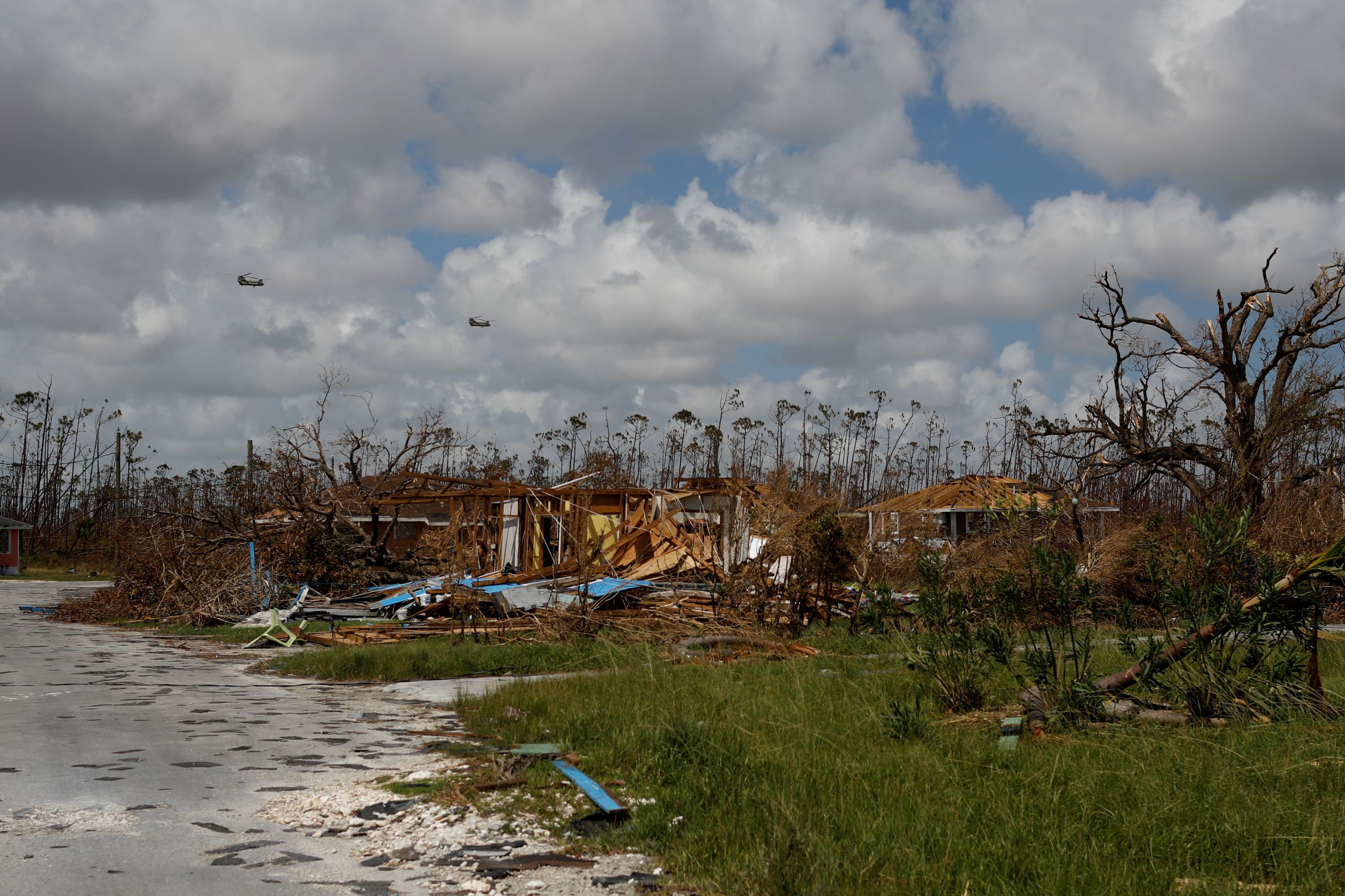
A tropical storm warning was in effect for most of the Northwestern Bahamas, including Great Abaco Island and Grand Bahama Island, the Miami-based National Hurricane Center (NHC) said. Those islands were ravaged when Hurricane Dorian ripped through the archipelago as a Category 5 storm two weeks ago.

Early Friday, the tropical disturbance was 235 miles (375 km) east-southeast of Freeport on Grand Bahama Island as it traveled northwest with winds of 30 mph.

The storm was expected to dump two to four inches of rain on the islands, where the powerful and slow-moving Dorian had ripped roofs off thousands of dwellings and dumped up to two feet of rain. In some areas, the new storm could drop up to 6 inches of rain through Sunday, the NHC said, but no storm surge was expected.

“Tropical storm force winds, heavy rain and high surf are expected” in the Bahamas, said Dennis Feltgen, the center’s spokesman. “Wet and windy, which is going to make the recovery over the northwest Bahamas that much more difficult.”

The storm is expected to pick up speed as it moves northwest on Friday and could hit Florida on Saturday, it said.

In Florida, a tropical storm watch was in effect for portions of the east-central coast early Friday. South Florida could see tropical storm-force winds as early as Friday evening, the NHC said.

The tropical cyclone was not expected to bring anywhere near the devastation of Dorian, which slammed into the Bahamas on Sept. 1 as a Category 5 storm. It was one of the strongest Atlantic hurricanes on record to hit land, packing top sustained winds of 185 miles per hour (298 kph).

With 1,300 people still missing, according to the Bahamian government, relief services are focused on search and rescue as well as providing food, water and shelter.

Aid groups rushed shelter material to residents living in the shells of former homes.

“We’re seeing plastic tarps go out all over the islands, and that’s extremely important because now you’ve got another tropical storm coming,” said Ken Isaacs, vice president of programs for U.S. relief organization Samaritan’s Purse.

United Nations Secretary-General Antonio Guterres will visit the Bahamas on Friday and Saturday to speak with people affected by the hurricane and the humanitarian teams assisting them. He planned to meet with Prime Minister Hubert Minnis in Nassau.

Minnis on Wednesday said the official death toll stood at 50 but was expected to rise. He said he was trying to remove “bureaucratic roadblocks” to bringing aid to areas where the devastation made it hard for relief teams to reach.

Former Prime Minister Hubert Ingraham said he believed “hundreds” were dead on Abaco “and significant numbers on Grand Bahama,” the Nassau Guardian newspaper reported on Thursday.

Officials have erected large tents in Nassau to house those made homeless by Dorian. They plan to erect tent cities on Abaco to shelter up to 4,000 people.

(Reporting by Zach Fagenson in Nassau; additional reporting by Andrew Hay in Taos, New Mexico, Dan Whitcomb in Los Angeles, Brendan O’Brien in Chicago and Rich McKay in Atlanta; editing by Jason Neely and David Gregorio)

Lurking Hermine spares much of U.S. East Coast, could regain hurricane strength

Tropical Storm Hermine is pictured off the coast of the U.S. Mid-Atlantic

By Daniel Trotta and Chris Prentice

NEW YORK (Reuters) – Atlantic storm Hermine, which has killed two people, lurked off the middle of the U.S. East Coast late on Sunday while threatening to regain hurricane strength, after having spared the region the brunt of its wind, rain and tidal surge.

Forecasters warned swimmers and boaters to avoid the risk of deadly surf churned up by the storm and stay out of treacherous waters during the Labor Day holiday weekend, when many Americans celebrate the end of summer.

Hermine was still packing maximum sustained surface winds of nearly 70 mph (113 kph) late on Sunday, and forecasters said it  could intensify slightly to reach hurricane strength again, before it starts to dwindle later on Monday.

But for now, its strongest winds were extending outward by about 230 miles (370 km), failing to reach U.S. shores.

Hermine was forecast to bring up to 2 inches (5 cm) of rain to southern New England on Monday, after having hit land in Florida on Friday, and churning up the southeastern seaboard.

Sandbags and tarps cover the entrance to a subway station near Battery Park as New York City prepares for potential flooding as post-tropical storm Hermine stalls off the east coast of the United States

Sandbags and tarps cover the entrance to a subway station near Battery Park as New York City prepares for potential flooding as post-tropical storm Hermine stalls off the east coast of the United States, September 4, 2016. REUTERS/Mark Kauzlarich

Then it merged with a conventional weather front, to be reclassified on Saturday as a post-tropical cyclone.

But Hermine was not expected to make landfall again, said Robbie Berg, an official of the National Hurricane Center.

A tropical storm warning remained in effect Sunday night from the Delaware and New Jersey shores north to New York’s Long Island and beyond to Martha’s Vineyard and Nantucket Island off Massachusetts, but was canceled for New York City, which Berg said appeared largely out of harm’s way.

Potential storm-surge inundation levels of no more than 1 to 3 feet (30 cm to 1 m) were expected in coastal areas.

As the threat to New Jersey waned, Governor Chris Christie ordered Island Beach State Park reopened for Monday, while warning that lingering rip currents and rough surf might still make the ocean unsafe for swimmers.

At 11 p.m. EDT on Sunday, Hermine’s center was about 325 miles (523 km) southeast of Long Island, the eastern tip of New York, the hurricane center said.

It was expected to “meander slowly” off the mid-Atlantic region, moving north-northeast at only 3 mph (5 kph) and stay at least 300 miles (480 km) from shore before beginning to weaken by Monday night, the agency said.

WANING STORM THREAT BEYOND COAST

The storm claimed at least two lives, in Florida and North Carolina, but the widespread power outages and flooding that battered Florida, Georgia and the Carolinas had yet to materialize farther north, where alarming news reports scared many tourists away from the beach on Sunday.

Those who stayed awoke to sunshine, but stronger-than-usual winds and choppy seas.

“It was a little overhyped by the media,” said Andrew Thulin, assistant general manager of Daddy O Hotel Restaurant in the New Jersey township of Long Beach.

“It killed the weekend for everybody down here.”

Officials mindful of the 2012 devastation of Superstorm Sandy took every precaution. Elsewhere in the state coastal roads were reported flooded, and beaches engulfed by the sea.

Hermine became the first hurricane to make landfall in Florida in 11 years, packing winds of 80 mph (129 kph), and knocking out power to 300,000 homes and businesses. Downgraded to a tropical storm within hours, it still packed a wallop.

(Additional reporting by Steve Gorman from Los Angeles and Chris Michaud from New York)