October 14 Ring of Fire solar eclipse across the US

Ring-of-Fire-Eclipse-United-States

Important Takeaways:

  • Rare ‘ring of fire’ solar eclipse will cross the U.S. on Saturday: Here’s how to see it
  • The astronomical event will take place Saturday. Weather permitting, sky-watchers in Oregon, Nevada, Utah, New Mexico and Texas, as well as slivers of California, Idaho, Colorado and Arizona, will be able to see the moon almost completely cover the sun, creating the effect of a fiery, orange-hued ring around the moon’s shadow. In all other states in the continental U.S., viewers will be treated to a partial solar eclipse, with the moon obscuring only part of the sun in the sky.
  • Solar eclipses are the results of cosmic confluences, occurring when the moon passes in front of the sun and temporarily blocks its light. Saturday’s event is what’s known as an annular solar eclipse — “annular” means “ring-shaped” in Latin.
  • On Saturday, sky-watchers along a roughly 125-mile-wide path that cuts from Oregon south to Texas and through Central and South America will be able to see the full “ring of fire” effect. Most people in North America outside the “path of annularity” will see a partial eclipse if skies are clear.
  • Sky-watchers in Oregon will be able to see the start of a partial eclipse at 8:06 a.m. PT. The period of annularity, when the “ring of fire” effect is visible, will last around 5 minutes. During that time, the point of maximum coverage for people in Eugene, Oregon, will occur at 9:18 a.m. PT. Maximum coverage will be at 9:20 a.m. PT in Alturas, California; at 9:23 a.m. PT in Battle Mountain, Nevada; at 10:28 a.m. MT in Richfield, Utah; at 10:35 a.m. MT in Albuquerque, New Mexico; and 11:54 a.m. CT in San Antonio.

Read the original article by clicking here.

Look up: Ring of Fire Solar Eclipse will be visible Oct 14

Ring-of-Fire-Solar-Eclipse

Important Takeaways:

  • ‘Ring of fire’ solar eclipse is coming to US in October. Here’s when (and where) you can see it.
  • An annular “ring of fire” solar eclipse will be visible across the Western Hemisphere on Oct. 14, and Americans across several Western states will be able to see it.
  • It’s called a “ring of fire” eclipse because only the outer ring of the sun will be visible during the height of the spectacle.
  • The annular eclipse will first be seen in the U.S. near Eugene, Oregon, before traveling across the country with visibility in parts of Nevada, Utah, New Mexico, Texas, California, Idaho, Colorado and Arizona. It will end in Texas.
  • A partial solar eclipse is expected to be visible in all 48 contiguous states, as well as Alaska.

Read the original article by clicking here.

Aftershock jolts Indonesia’s Lombok as death toll jumps to 259

A villager stands near collapsed house at Kayangan district after earthquake hit on Sunday in North Lombok, Indonesia, August 7, 2018. REUTERS/Beawiharta

By Kanupriya Kapoor

PEMENANG, Indonesia (Reuters) – A magnitude 6.2 aftershock rocked Indonesia’s Lombok on Thursday, sparking fresh panic on the tropical tourist island as the official death toll from a powerful earthquake four days earlier almost doubled to 259.

Reuters witnesses reporting on the aftermath of Sunday’s quake in the north of the island said buildings and walls that had already been weakened collapsed, and people ran out onto roads even as rocks tumbled down from hillsides.

“Evacuees and people ran out of houses when they felt the strong shake of the 6.2 magnitude quake,” Sutopo Purwo Nugroho, a spokesman for Indonesia’s disaster mitigation agency (BNPB), said on Twitter. “People are still traumatized. Some buildings were damaged further because of this.”

People are seen running out of Bali's Ngurah Rai International Airport, Indonesia August 9, 2018 in this still image taken from a video obtained from social media. DOY SAFANDO BALI/via REUTERS

People are seen running out of Bali’s Ngurah Rai International Airport, Indonesia August 9, 2018 in this still image taken from a video obtained from social media. DOY SAFANDO BALI/via REUTERS

Officials said the epicenter of the aftershock was on land and so there was no risk of a tsunami.

The United States Geological Survey recorded the latest quake at 5.9, at a depth of 10 km (six miles).

BNPB’s toll of verified deaths from Sunday’s 6.9 magnitude quake was raised on Thursday to 259 from 131.

“This number will continue increasing as rescue teams continue to find victims under collapsed buildings,” the agency said in a statement.

A humanitarian crisis is also looming in Lombok, where thousands have been left homeless and in desperate need of clean water, food, medicine and shelter.

Authorities made announcements over loudspeakers at evacuation sites, urging people to remain calm and stay inside tents or find open space if they were inside or near buildings.

“Please stay calm, this is just an aftershock and it will be over soon, there’s no need to be scared,” one official announced.

Officials said about three-quarters of Lombok’s rural north had been without electricity since Sunday, although power had since been restored in most areas before the aftershock. Aid workers have found some villages hard to reach because bridges and roads were destroyed.

Ruslan, a 29-year-old resident of Pemenang on the northwestern shoulder of Lombok, said he had already been anxious about aftershocks before the latest jolt.

“My heart jumps if even the door slams hard. It’s difficult to get used to,” he said. “We are still scared to go into the house. At the most we go in quickly to grab something and then run back out.”

Indonesian soldiers unload relief aid for earthquake victims from a plane at an airbase in Mataram, Lombok, Indonesia August 9, 2018 in this photo taken by Antara Foto. Antara Foto/Ahmad Subaidi/via REUTER

Indonesian soldiers unload relief aid for earthquake victims from a plane at an airbase in Mataram, Lombok, Indonesia August 9, 2018 in this photo taken by Antara Foto. Antara Foto/Ahmad Subaidi/via REUTERS

Thousands of tourists have left Lombok since Sunday, fearing further earthquakes, some on extra flights provided by airlines and others on ferries to the neighboring island of Bali.

Indonesia sits on the Pacific Ring of Fire and is regularly hit by earthquakes. In 2004, the Indian Ocean tsunami killed 226,000 people in 13 countries, including more than 120,000 in Indonesia.

(Additional reporting by Bernadette Christina Munthe and Fransiska Nangoy in JAKARTA; Writing by John Chalmers; Editing by Nick Macfie)

Magnitude 6.1 quake in Japan’s Osaka area kills three, stops factories

Smoke arise from a house where a fire breaks out, in Takatsuki, Osaka prefecture, western Japan, in this photo taken by Kyodo June 18, 2018. Mandatory credit Kyodo/via REUTERS

By Kaori Kaneko and Malcolm Foster

TOKYO (Reuters) – A magnitude 6.1 earthquake shook Osaka, Japan’s second-biggest metropolis, early on Monday, killing three people, halting factory lines in an industrial area and bursting water mains, government and company officials said.

No tsunami warning was issued. Prime Minister Shinzo Abe said authorities were assessing damage and their top priority was the safety of residents. About 150 people were injured, the broadcaster NHK said, lowering an earlier toll after a revision by city officials.

People cycle on a flooded road damaged after an earthquake hit Osaka, Japan June 18, 2018, in this still image taken from a video obtained from social media. MANDATORY CREDIT. Twitter/@tw_hds/via REUTERS

People cycle on a flooded road damaged after an earthquake hit Osaka, Japan June 18, 2018, in this still image taken from a video obtained from social media. MANDATORY CREDIT. Twitter/@tw_hds/via REUTERS

Live footage showed toppled walls, broken windows and gushing burst water mains after the quake hit Osaka, which will host next year’s Group of 20 summit, just before 8 a.m. (2300 GMT Sunday) as commuters were heading to work.

Quakes are common in Japan, part of the seismically active “Ring of Fire” that stretches from the South Pacific through Indonesia and Japan, across to Alaska and down the west coast of North, Central and South America.

The epicenter of Monday’s earthquake was just north of Osaka city at a depth of 13 km (8 miles), said the Japan Meteorological Agency. The agency originally put the magnitude at 5.9 but later raised it to 6.1.

The quake struck an important industrial area of central Japan.

Osaka-based Panasonic said it was halting production at three of its plants. Daihatsu Motor Co, a unit of Toyota Motor Corp, stopped its factories in Osaka and Kyoto while it checked for damage. It said it would resume operations at the Osaka plant on Monday evening.

Tractor maker Kubota Corp. said it halted two plants in the area, while air conditioner maker Daikin Industries Ltd suspended operations at two plants, one of which had restarted by noon.

Honda Motor Co. and Mitsubishi Motors said they were resuming operations after suspensions and safety checks. Sharp Corp also resumed work at a joint venture plant with parent Hon Hai Precision Industry that it had stopped for safety checks.

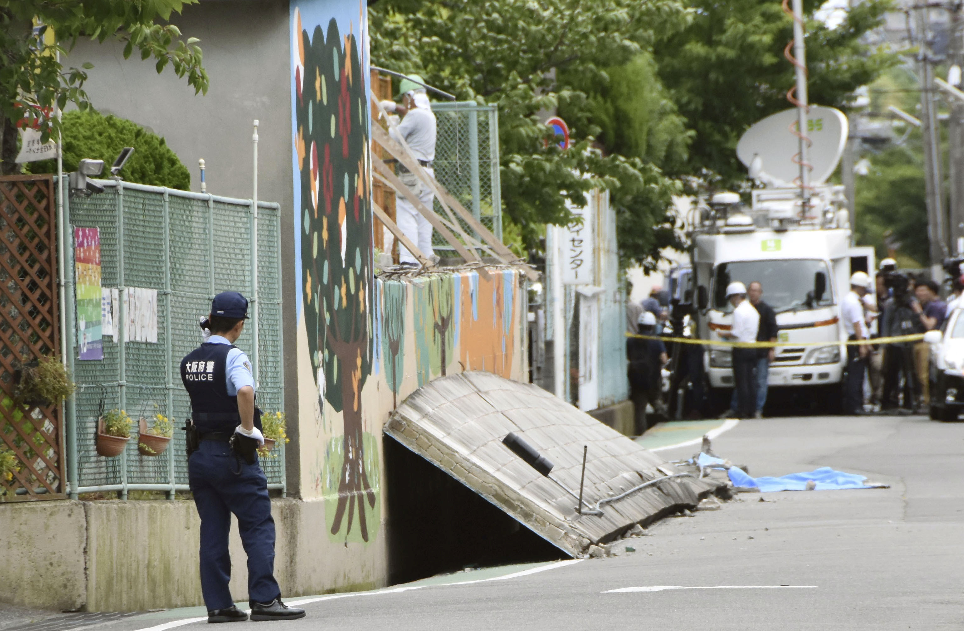
Three people were killed, authorities said. Collapsing walls killed a 9-year-old girl as she walked to school and a man in his 80s, Japanese media said. Another man in his 80s was killed when a bookcase fell on him.

A police officer stands guard at the site where a girl was killed by fallen wall caused by an earthquake at an elementary school in Takatsuki, Osaka prefecture, western Japan, in this photo taken by Kyodo June 18, 2018. Mandatory credit Kyodo/via REUTERS ATTENTION EDITORS - THIS IMAGE WAS PROVIDED BY A THIRD PARTY. MANDATORY CREDIT. JAPAN OUT. NO COMMERCIAL OR EDITORIAL SALES IN JAPAN.

A police officer stands guard at the site where a girl was killed by fallen wall caused by an earthquake at an elementary school in Takatsuki, Osaka prefecture, western Japan, in this photo taken by Kyodo June 18, 2018. Mandatory credit Kyodo/via REUTERS ATTENTION EDITORS – THIS IMAGE WAS PROVIDED BY A THIRD PARTY. MANDATORY CREDIT. JAPAN OUT. NO COMMERCIAL OR EDITORIAL SALES IN JAPAN.

‘TERRIFIED, CONFUSED’

“We were sleeping and it woke us up abruptly,” said Kate Kilpatrick, 19, an American who was staying in a hotel in Osaka when the quake hit.

“It was so terrifying because this is my first earthquake. I thought it was a nightmare because I was so confused,” she said. “The whole world was aggressively shaking.”

Kilpatrick, visiting Japan for the first time, said alarms went off almost immediately in the hotel and a loudspeaker told guests to stay away from windows.

No irregularities were detected at the Mihama, Takahama and Ohi nuclear plants to the north of Osaka, Kansai Electric Power said. More than 170,000 households in Osaka and neighboring Hyogo prefecture lost power temporarily but it was restored within two hours, the utility said.

Most trains in the Osaka area were still not running by late afternoon, police said.

Osaka prefecture, which includes the city and surrounding areas, has a population of 8.8 million. The city is close to Kobe, which was hit by a deadly magnitude 6.9 quake in 1995.

A massive 9.0 quake hit much further to the north in March 2011, triggering a huge tsunami that killed some 18,000 people and triggered the world’s worst nuclear disaster in a quarter of a century at Tokyo Electric Power’s Fukushima Daiichi nuclear plant.

Japan introduced a law after the Kobe quake requiring owners of large buildings such as hotels and hospitals to have their buildings inspected for earthquake resistance.

(Reporting by Kaori Kaneko, Mari Saito, Kiyoshi Takenaka, Osamu Tsukimori, Makiko Yamazaki, Naomi Tajitsu and Linda Sieg; Writing by Malcolm Foster; Editing by Paul Tait and Darren Schuettler)

Major quake cuts communications, halts oil and gas operations in Papua New Guinea

A supplied image shows a landslide and damage to a road located near the township of Tabubil after an earthquake that struck Papua New Guinea's Southern Highlands, February 26, 2018. Jerome Kay/Handout via REUTERS

By Charlotte Greenfield and Sonali Paul

WELLINGTON/MELBOURNE (Reuters) – At least one company began evacuating non-essential personnel after a powerful 7.5 magnitude earthquake hit Papua New Guinea’s energy-rich interior on Monday, causing landslides, damaging buildings and closing oil and gas operations.

The tremor hit in the rugged, heavily forested Southern Highlands about 560 km (350 miles) northwest of the capital, Port Moresby, at around 3.45 a.m. local time (1545 GMT Sunday), according to the U.S. Geological Survey (USGS).

A spokesman at Papua New Guinea’s National Disaster Center said by telephone the affected area was very remote and the agency could not properly assess damage until communication was re-established.

He said there were no confirmed casualties, although the International Red Cross (IRC) in Papua New Guinea said some reports indicated there were “fears of human casualties”.

“It’s a very serious all across the Southern Highlands and also all over the western highlands. People are definitely very frightened,” Udaya Regmi, the head of the IRC in Papua New Guinea, said by telephone from Port Moresby.

A supplied image shows a landslide and damage to a road located near the township of Tabubil after an earthquake that struck Papua New Guinea's Southern Highlands, February 26, 2018. Jerome Kay/Handout via REUTERS

A supplied image shows a landslide and damage to a road located near the township of Tabubil after an earthquake that struck Papua New Guinea’s Southern Highlands, February 26, 2018. Jerome Kay/Handout via REUTERS

The PNG government also said it had sent disaster assessment teams. At least 13 aftershocks with a magnitude of 5.0 or more rattled the area throughout the day, according to USGS data, but no tsunami warnings were issued.

“The Papua New Guinea Defense Force has also been mobilized to assist with the assessment and the delivery of assistance to affected people as well as the restoration of services and infrastructure,” Isaac Lupari, the chief secretary to the government, said in a statement.

ExxonMobil said it had shut its Hides gas conditioning plant and that it believed administration buildings, living quarters and a mess hall had been damaged. It also said it had suspended flights into the nearby Komo airfield until the runway could be surveyed.

“Due to the damage to the Hides camp quarters and continuing aftershocks, ExxonMobil PNG is putting plans in place to evacuate non-essential staff,” the company said in an emailed statement.

Gas is processed at Hides and transported along a 700 km (435 miles) line that feeds a liquefied natural gas plant near Port Moresby for shipping.

PAPUA PANIC

PNG oil and gas explorer Oil Search said in a statement it had also shut production in the quake-affected area.

The giant Grasberg copper mine operated by the Indonesian unit of Freeport McMoRan in neighboring Papua province was not affected, a Jakarta-based spokesman said.

However, the quake and several aftershocks caused panic in Jayapura, the capital of Indonesian Papua, Indonesia’s disaster mitigation agency said in a statement, but there were no reports of casualties or damage there.

The IRC’s Regmi said communications were “completely down” in Tari, one of the larger settlements near the quake’s epicenter, and that landslides had cut roads.

Several other aid and missionary agencies said poor communications in the area made damage and injury assessment difficult.

“The bush structures that they build tend to handle earthquakes extremely well,” Christian missionary Brandon Buser told Reuters after contacting several remote villages by shortwave radio.

Earthquakes are common in Papua New Guinea, which sits on the Pacific’s “Ring of Fire”, a hotspot for seismic activity due to friction between tectonic plates.

“This is the Papuan fold-and-thrust belt, so it’s a typical movement of faults in that region, but it’s big,” said Chris McKee, acting director of the Geohazards Management Division in Port Moresby.

Part of PNG’s northern coast was devastated in 1998 by a tsunami, generated by a 7.0 quake, which killed about 2,200 people.

(For a graphic on ‘Papua New Guinea’s 7.5 magnitude earthquake’ click http://tmsnrt.rs/2ow1YLR)

(Reporting by Charlotte Greenfield in WELLINGTON and Sonali Paul in MELBOURNE; Additional reporting by Fergus Jensen in JAKARTA and Tom Westbrook in SYDNEY; Writing by Jonathan Barrett; Editing by Paul Tait)

5.3-magnitude quake shakes big island of Hawaii: USGS

LOS ANGELES (Reuters) – A 5.3-magnitude earthquake shook the Big Island of Hawaii on Thursday, near the Kilauea Volcano, the U.S. Geological Survey said.

There were no immediate reports of injuries or substantial damage from the quake and the Pacific Tsunami Warning Center said no tsunami was expected to result.

According to the USGS, the temblor rattled the Big Island at 7:01 a.m. local time (1601 GMT) at a depth of 8 kilometers (4.9 miles).

“As in all earthquakes, be aware of the possibility of aftershocks,” Hawaii County Civil Defense said in an alert.

“If the earthquake was strongly felt in your area, precautionary checks should be made for any damages, especially to utility connections of gas, water and power,” the agency said.

(Reporting by Dan Whitcomb; Editing by Bernadette Baum)

7.9 earthquake hits Saturday in Ring of Fire’s, Papua New Guinea

By Jonathan Barrett and Harry Pearl

SYDNEY (Reuters) – People living along Papua New Guinea’s coastline fled to higher ground on Saturday after a 7.9 magnitude earthquake struck east of the Pacific nation, triggering a tsunami warning for parts of its archipelago.

A couple of hours after the quake, the Pacific Tsunami Warning Center (PTWC) said the threat had largely passed, although it said government agencies should continue to monitor coastal tides.

“Based on all available data … the tsunami threat from this earthquake has now passed,” the PTWC said in an updated and final alert after the quake, which struck 157 km (98 miles) east of Rabaul.

The major tremor initially triggered a more widespread tsunami warning for the Pacific region, including Indonesia and the Solomon Islands, but that was pulled back after the U.S. Geological Survey (USGS) downgraded the magnitude slightly from 8. It also revised the depth of the tremor to 103.2 km from its original estimate of 73 kms.

Many residents in the northern parts of the autonomous region of Bougainville sought higher ground amid warnings that tsunami waves were possible.

“The town residents have vacated the whole place; those in the villages live higher up, so they’re ok, it’s just those near the coast,” local resident Christabel Biasu told Reuters by phone.

Quakes are common in Papua New Guinea, which sits on the Pacific’s “Ring of Fire”, a hotspot for seismic activity due to friction between tectonic plates. There were no immediate reports of damage or casualties after Saturday’s major tremor.

A nurse at Buka General Hospital in Bougainville said the quake was so strong it felt like the building she was sleeping in would topple. She said patients were being moved a few kilometers to higher ground.

“We have about 16 beds,” she told Reuters by phone, declining to give her name. “Most of them are already a suburb up.”

The small Pacific nation of Nauru, where one of Australia’s offshore immigration detention centers is located, had a tsunami warning in place, according to the official government Twitter account.

Residents in other parts of Papua New Guinea, including the capital of Port Moresby and Kavieng in the northern tip of New Ireland island, said they had not felt the quake, and no evacuation plans were in place.

New Zealand also canceled an earlier tsunami warning.

(Writing by Jane Wardell; Editing by Ian Geoghegan)

Indonesian Volcano Blankets Provincial Capital With Ash

Indonesia’s Mount Sinabung has now released a plume of ash strong enough to cover the provincial capital of North Sumatra.

The residents of Medan now have to don masks to be able to breathe when they step outside of their homes or businesses.  The city is located 31 miles from the volcano and has a population of 3.4 million people.

The monitoring post watching the mountain says seven hot ash avalanches slid down the mountain on Wednesday for a distance of 10,500 feet.  The ash cloud from the eruptions rose over a mile into the sky.

Mount Sinabung, located on the Pacific Ring of Fire, had been dormant for 400 years before roaring to life in 2010.  Scientists who are investigating the rebirth of dormant volcanoes have published a study suggesting that earthquakes could be the cause.

Solid Earth, the journal of the European Geosciences Union, suggests that “megathrust earthquakes” in the region around previously dormant volcanoes could be the cause of new eruptions.  In the case of Mount Sinabung, three megathrust quakes between 2005 and 2007 could have sparked the volcano’s 2010 awakening. These earthquakes include the magnitude 8.6 earthquake in 2005, the magnitude 7.9 earthquake in 2007, and another magnitude 8.4 earthquake in 2007.

Indonesia Evacuates More Due To Volcano

Indonesian officials are evacuating hundreds more residents near Mount Sinabung as the volcano continues to increase a lava flow and eruptions.

Gede Suantika, government volcanologist, said that 28 hot ash avalanches took place in one day on Mount Sinabung.  The lava dome on the mountain continues to build in size creating the  possibility of a serious eruption.

The number of people evacuated in recent weeks has topped 3,000.

The circle of exclusion around the mountain is now 3 miles.  Residents forced to flee have been complaining about the forced evacuation, saying they are farmers and they have no way to make a living if they are forced off their land.

However, a Saturday blast of hot ash spread two miles from the volcano, leading the government to expand the forced evacuation and removal of angry residents.

The mountain has caused scientists to keep it on the highest alert level since June 2 with a lava dome estimated at 106 million cubic feet.

The mountain came alive after 400 years of dormancy in 2010.  Last year, an eruption left 17 people dead.  The mountain is on the Pacific Ring of Fire.