North Carolina feels first bite of mammoth Hurricane Florence

A man walks his dogs before Hurricane Florence comes ashore on Carolina Beach, North Carolina, U.S., September 13, 2018. REUTERS/Carlo Allegri

By Ernest Scheyder

WILMINGTON, N.C. (Reuters) – Coastal North Carolina felt the first bite of Hurricane Florence on Thursday as winds began to rise, a prelude to the slow-moving tempest that forecasters warned would cause catastrophic flooding across a wide swath of the U.S. southeast.

The center of Florence, no longer classified as a major hurricane but still posing a grave threat to life and property, is expected to hit North Carolina’s southern coast Friday, then drift southwest before moving inland on Saturday, enough time to drop feet of rain, according to the National Hurricane Center.

Businesses and homes in the storm’s path were boarded up and thousands of people had moved to emergency shelters, officials said, urging anyone who remained near the coast to flee. Millions were expected to lose power, perhaps for weeks.

“There is still time to leave,” North Carolina Governor Roy Cooper told “CBS This Morning” on Thursday. “This is an extremely dangerous situation.”

Florence’s maximum sustained winds were clocked on Thursday at 110 miles per hour (175 kph) after it was downgraded to a Category 2 on the five-step Saffir-Simpson scale, according to the NHC. The storm was about 170 miles (275 km) east of Wilmington, North Carolina.

Tropical storm-force winds of at least 39 miles per hour (63 kph) extended outward up to 195 miles (315 km) from its center and were due to begin raking North Carolina’s Outer Banks barrier islands around 8 a.m. (1200 GMT) before stretching over low-lying areas reaching from Georgia north into Virginia.

The rain posed a greater danger, forecasters warned, with some spots getting as much as 40 inches (1 m) of precipitation, enough to cause devastating flash floods miles from the coast.

In all, an estimated 10 million people live in areas expected to be placed under a hurricane or storm advisory, according to the U.S. Weather Prediction Center. More than one million people had been ordered to evacuate the coastlines of the Carolinas and Virginia.

Besides inundating the coast with wind-driven storm surges of seawater as high as 13 feet (four meters) along the Carolina coast, Florence could dump 20 to 30 inches (51-76 cm) of rain over much of the region.

If it stalls over land, downpours and flooding would be especially severe. Heavy rains were forecast to extend into the Appalachians, affecting parts of Alabama, Tennessee, Kentucky and West Virginia.


TEST FOR TRUMP

The storm will be a test of President Donald Trump’s administration less than two months before elections that will determine control of Congress. After facing severe criticism for its handling of last year’s Hurricane Maria, which killed some 3,000 people in Puerto Rico, Trump has vowed a vigorous response.

“We are completely ready for hurricane Florence, as the storm gets even larger and more powerful. Be careful!” Trump said on Twitter.

The head of the Federal Emergency Management Agency, which is in charge of disaster response, has come under investigation over his use of government vehicles, Politico reported on Thursday.

Emergency declarations were in force in North and South Carolina, Virginia, Maryland and the District of Columbia.

Emergency preparations included activating more than 2,700 National Guard troops, stockpiling food, setting up shelters, switching traffic patterns so major roads led away from shore, and securing 16 nuclear power reactors in the Carolinas and Virginia.

Some in Wilmington could not resist getting one last look at their downtown before the storm hit.

“We just thought we’d go out while we still can,” said Amy Baxter, on a walk near the city’s waterfront with her husband, two sons, and dog.

Baxter, a 46-year-old homemaker, and her family plan to ride out Florence at home with board games and playing cards.

“We live in a house that’s more than 100 years old,” Baxter said. “We feel pretty safe.”

(For graphic on forecast rainfall in inches from Hurricane Florence, click https://tmsnrt.rs/2oZFKSb)

(Additional reporting by Bernie Woodall in Fort Lauderdale, Florida, Brendan O’Brien in Milwaukee and Stephanie Nebehay in Geneva; Editing by Scott Malone)

Typhoon bears down on Tokyo and northeast Japan coast, flights disrupted

Passersby using an umbrella struggle against a heavy rain and wind as Typhoon Shanshan approaches Japan's mainland in Tokyo, Japan August 8, 2018. REUTERS/Toru Hanai

TOKYO (Reuters) – A powerful typhoon was approaching Tokyo on Wednesday evening, threatening Pacific coastal regions to the northeast of the capital with heavy rains and high winds, leading to flight cancellations and evacuation advisories in some areas.

The center of typhoon “Shanshan”, a Chinese girl’s name, was located 200 km (125 miles) southeast of Tokyo as of 9:00 p.m. (8.00 a.m. ET), and is expected to move north along the east coast of Japan’s main island on Thursday, possibly snarling the morning rush hour.

The Japan Meteorological Agency warned that Tokyo and surrounding areas could get as much as 300 mm (12 inches) of rain in the 24 hours to 6:00 p.m. on Thursday, with winds gusting as high as 180 kmh (111 mph).

Shanshan is expected to move slowly, meaning heavy rain may fall in one area for an extended period, the agency said.

The city of Mobara, east of Tokyo, issued an evacuation advisory for its entire population of about 90,000 people.

Several other municipalities near Tokyo also issued evacuation advisories for some residents, bringing the total number of people affected to more than 100,000, according to public broadcaster NHK.

NHK also said airlines had canceled more than 160 flights.

The western Japan regions hit by deadly floods in July look set to be spared any damage from the typhoon as it winds its way up the northeastern coast.

Japan has experienced one weather disaster after another since the start of July, including a record-breaking heatwave that saw temperatures surge to 41.1 Celsius (106 Fahrenheit) and had killed at least 132 people as of August 5.

(Reporting by Elaine Lies, Kiyoshi Takenaka; Editing by Michael Perry and Hugh Lawson)

One killed in raging California wildfire as residents flee

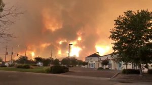
Smoke and flames are seen as a wildfire spreads through Redding, California, the U.S., July 26, 2018, in this still image taken from a video obtained from social media. Cody Markhart/via REUTERS

By Fred Greaves

REDDING, Calif (Reuters) – One person was killed in a rapidly moving wildfire that sent residents fleeing from a northern California city where homes and businesses burned and power was cut on Friday, fire officials said.

A bulldozer operator was killed in the so-called Carr Fire, a blaze in Shasta County that has tripled in size in the last two days to 28,000 acres (11,300 hectares), the state’s forestry and fire protection department (Cal Fire) said.

The blaze moved east from the communities of Whiskeytown and Shasta and crossed the Sacramento River and now threatens hundreds of homes on west side of the city of Redding. Cal Fire said it ignited on Monday by the mechanical failure of a vehicle.

“The fire is moving so fast that law enforcement is doing evacuations as fast as we can. There have been some injuries to civilians and firefighters,” California Department of Forestry and Fire Protection spokesman Scott McLean told the Sacramento Bee newspaper.

“It’s way too dynamic and burning quickly.”

Local and state fire officials were not available to confirm details of injuries or the extent of damage.

Roads out of the city of 90,000 people were jammed with motorists trying to escape the flames, social media postings showed.

Two residents who chose not to leave were 61-year-old Rob Wright and his wife, who planned to fight off flames from approaching their house with a high-powered water hose.

“We were fortunate enough that the wind changed about hours ago and it is pushing the fire back,” said Wright, at about 1:15 a.m. local time. “We are just waiting it out … crossing our fingers and hoping for the best.”

Smoke and flames are seen as a wildfire spreads through Redding, California, the U.S., July 26, 2018, in this still image taken from a video obtained from social media. @pbandjammers/via REUTERS

Smoke and flames are seen as a wildfire spreads through Redding, California, the U.S., July 26, 2018, in this still image taken from a video obtained from social media. @pbandjammers/via REUTERS

“TRYING TO MAKE A STAND”

Scorching temperatures above 100 degrees F (37 C), erratic winds and low humidity that are expected in the area could fan the blaze, which 1,700 firefighters are battling, Cal Fire and weather forecasters said.

“Right now they’re doing what they can, they’re trying to make a stand where they can, if possible,” McLean said. “It’s extreme. It’s blowing up off and on again.”

McLean added that the wildfire was in an area of rolling hills and not in “house-to-house neighborhoods.”

Video footage and images posted on social media showed flames engulfing structures as an orange glow lit up the night sky.

Residents were evacuated to a nearby college and elementary school and a local ABC news station stopped covering the fire in order to evacuate. The Mercy Medical Center in Redding evacuated its neonatal intensive care unit, it said in a statement.

Multiple power outages were reported, the city said on its website, adding that the electric utility was shutting off power in its northern areas.

California Governor Jerry Brown declared a state of emergency in Shasta and Riverside Counties on Thursday over the Carr and Cranston fires.

The California Governor’s Office of Emergency Services said it had activated a state operations center to provide assistance in multiple wildfires burning in Northern and Southern California.

Two weeks ago, a firefighter was killed fighting the Ferguson Fire east of San Francisco when a bulldozer he was using to cut containment lines overturned. Seven other firefighters have been hurt.

(Additional reporting by Brendan O’Brien in Milwaukee; Editing by Kevin Liffey)

Raging wildfire in Southern California forces thousands to flee

Image of Cranston Fire in California, arson suspect has been arrested abc news channel 3 CBS local 2

By Dan Whitcomb

LOS ANGELES (Reuters) – Thousands of residents in Southern California were forced from their homes by a raging wildfire which remained unchecked early on Thursday as it pushed toward their mountain resort communities.

The so-called Cranston Fire, believed to have been started by arson, grew rapidly by noon to cover 4,700 acres (1,900 hectares) around 90 miles (145 kms) east of Los Angeles in the San Jacinto Mountains, the San Bernardino National Forest agency said on Twitter.

The blaze forced 3,200 people to evacuate in communities such as Idyllwild, Mountain Center and Lake Hemet as it destroyed five structures and threatened 2,100 homes, the agency said.

Brandon McGlover, 32, of Temecula, was arrested on Wednesday and accused of starting multiple fires including the Cranston Fire, fire officials said in a statement.

The fire along with dozens of others through the U.S. West were being supercharged by extreme temperatures above 100 degrees Fahrenheit (37 C), erratic winds and low humidity, factors that were expected to remain in the region through Thursday.

To the northeast, the Ferguson Fire forced the heart of the Yosemite National Park to close on Wednesday after the blaze burning just to the west jumped fire lines overnight, pouring thick smoke into the valley and forcing visitors to pack up camp and flee.

Heavy black smoke from the 41,500-acre wildfire, which broke out on July 13 in the Sierra Nevada Mountains some 170 miles east of San Francisco, prompted Yosemite park officials to shut the main visitor hub of Yosemite Valley as well as Wawona and Mariposa Grove.

The smoke reduced visibility and posed health risks to visitors in the popular tourist destination as well as park employees, Mackensen said.

A firefighter died and seven others have been hurt battling the flames, which were 25 percent contained as of Wednesday afternoon.

The blaze is one of some 60 major wildfires burning in the United States this week that have scorched an area of about 1.2 million acres (485,620 hectares). Most are in western states, with blazes also in central Texas and Wisconsin, according to the National Interagency Fire Center.

As of July 25, wildfires had burned through 3.94 million acres (1.59 million hectares) this year, above the 10-year average for the same period of 3.54 million acres (1.43 million hectares), it said.

(Reporting by Brendan O’Brien in Milwaukee; Editing by David Holmes)

Greek inferno kills at least 80, many missing

An electricity pole stands among burnt trees following a wildfire in Neos Voutzas, near Athens, Greece, July 25, 2018. REUTERS/Alkis Konstantinidis

By George Georgiopoulos and Michele Kambas

ATHENS (Reuters) – The death toll from a fire which ripped through a Greek coastal town stood at 80 on Wednesday, with dozens of people unaccounted for as forensic experts tried to identify victims who were burned alive.

With most of the corpses badly charred, identification of the dead will be challenging, experts said, meaning no fast closure in sight for suffering relatives.

Hundreds of people were trapped in the eastern resort of Mati on Monday night as flames whipped around them. Many jumped into the sea to survive, but others died from suffocation either in their cars or trapped on the edge of steep cliffs.

A house burns as a wildfire rages at the village of Mati, near Athens. REUTERS/Alkis Konstantinidis

A house burns as a wildfire rages at the village of Mati, near Athens.
REUTERS/Alkis Konstantinidis

The Greek fire brigade said the death of a survivor in hospital had brought the toll up to 80. The service was also receiving dozens of calls reporting missing persons, but it was unclear if some of them were among those found dead, a spokesperson said.

With many burned beyond recognition, Greek coroners began the grim task of trying to identify the victims of the wildfires near Athens, having to rely on DNA or dental records as angst over missing persons mounted among relatives.

“Work has started on identifying the victims of the wildfires but the majority of the bodies are totally charred,” Grigoris Leon, head of the Hellenic Society of Forensic Medicine, told Reuters.

The post-mortems and identification procedures are taking place at a morgue at Shisto, west of Athens. Leon said this will involve teamwork by coroners, forensic dentistry experts from the Athens University’s Dental School, and the Greek police’s forensic service.

Post-mortems to determine the cause of death are mandatory by Greek law and the last stage after the conclusion of identification procedures.

Burnt houses are seen following a wildfire at the village of Mati, near Athens, Greece, July 25, 2018. REUTERS/Alkis Konstantinidis

Burnt houses are seen following a wildfire at the village of Mati, near Athens, Greece, July 25, 2018. REUTERS/Alkis Konstantinidis

Rescue teams combed through the area and the sea on Wednesday, trying to locate anything which could offer clarity on the missing, who are thought to number about 40.

“It was a really terrible situation here,” said Finnish tourist Jaakob Makinen. “We had to run away from the hotel, we ran through the beach, along the beach and then we were caught by fire, so kind of surrounded, we had to go into the water,” he told Reuters Television.

He and others spent several hours in the water.

It was unclear what caused the fire, which spread rapidly through Mati, a maze of narrow streets and dense forest. But some suggested that the sheer force of winds, thick pine, fire and panic was a deadly combination making even the most well-executed evacuation plan futile.

“You can’t leave. My house was up in flames in two minutes,” Elias Psinakis, the Mayor of Marathon, told Greece’s SKAI TV. “With eight Beaufort (wind) and pine you don’t even have time.”

“Armageddon,” wrote the daily newspaper Ethnos on its front page, a reference to the Biblical location prophesizing the end of times. It carried a photo of a burned Greek flag hanging among the branches of a charred tree.

A man walks among burnt cars following a wildfire at the village of Mati, near Athens. REUTERS/Alkis Konstantinidis

A man walks among burnt cars following a wildfire at the village of Mati, near Athens. REUTERS/Alkis Konstantinidis

Fires are common in Greece in the summer months. However, one outspoken cleric had at least one theory of what caused it.

In a vitriolic post, Bishop Ambrosios of Kalavryta said it was the wrath of God because Greek Prime Minister Alexis Tsipras is a stated atheist. It drew a sharp response from the Church, which distanced itself from the Bishop’s remarks.

Tsipras declared three days of national mourning.

(Additional reporting by Angeliki Koutantou, Alkis Konstantinidis and Vassilis Triantafyllou, Editing by Angus MacSwan)

Thousands evacuated ahead of fast-moving California wildfire

A house burns as firefighters battle a fast-moving wildfire that destroyed homes driven by strong wind and high temperatures forcing thousands of residents to evacuate in Goleta, California, U.S., early July 7, 2018. REUTERS/Gene Blevin

By Dan Whitcomb

LOS ANGELES (Reuters) – Santa Barbara County officials declared a local emergency on Saturday as a fast-moving wildfire driven by strong winds and triple-digit temperatures destroyed 20 homes and other structures and forced thousands of residents to evacuate.

The Holiday Fire, one of more than three dozen major blazes burning across the U.S. West, broke out on Friday evening near the beach community of Goleta, California, west of Santa Barbara, and raced through the seaside foothills.

Firefighters work at the site of a wildfire in Goleta, California, U.S., July 6, 2018 in this image obtained on social media. Mike Eliason/Santa Barbara County Fire/via REUTERS

Firefighters work at the site of a wildfire in Goleta, California, U.S., July 6, 2018 in this image obtained on social media. Mike Eliason/Santa Barbara County Fire/via REUTERS

The flames forced more than 2,000 people to flee their homes, and left thousands more without power, prompting the emergency declaration which frees additional funds for the firefighting effort.

Some 350 firefighters took advantage of a period of light winds early on Saturday to contain as much as possible of the blaze, which has burned through 50 to 80 acres (20 to 32 hectares), fire officials said.

“It was a small fire but it had a powerful punch to it,” Santa County Fire spokesman Mike Eliason said. “We’re going to hit it hard today.”

Winds were expected to pick up again as temperatures rise in the afternoon, he said.

Dozens of blazes have broken out across the western United States, fanned by scorching heat, winds and low humidity in a particularly intense fire season.

This year’s fires had burned more than 2.9 million acres (1.17 million hectares) through Friday, already more than the annual average of about 2.4 million acres (971,000 hectares) over the last 10 years, according to the National Interagency Fire Center.

On Friday, the remains of an unidentified person were found near a home burned to the ground by the Klamathon fire, which broke out on Thursday near California’s border with Oregon. It marked the first fatality of the fire season in California.

A boat burns as fast-moving wildfire that destroyed homes driven by strong wind and high temperatures forcing thousands of residents to evacuate in Goleta, California, U.S., early July 7, 2018. REUTERS/Gene Blevin

A boat burns as fast-moving wildfire that destroyed homes driven by strong wind and high temperatures forcing thousands of residents to evacuate in Goleta, California, U.S., early July 7, 2018. REUTERS/Gene BlevinsThe Klamathon, which has destroyed 15 structures and blackened nearly 22,000 acres (8,900 hectares), was only 5 percent contained as of Saturday.

Elsewhere in Northern California, the County Fire has charred 88,375 acres (35,764 hectares) in sparsely populated wooded areas of Napa and Yolo Counties.

Some 3,660 firefighters faced with inaccessible terrain, high temperatures and low humidity, were battling the fire, which was only 48 percent contained. It has destroyed 10 structures, damaged two and threatened 110.

In Colorado, officials said fire crews had made “much progress” battling the Spring Creek fire, which broke out on Juornia, ne 27 and has consumed 106,985 acres (43,295 hectares). It was 43 percent contained on Saturday, the officials said.

(Reporting by Brendan O’Brien in Milwaukee, Peter Szekely in New York and Dan Whitcomb in Los Angeles; Editing by John Stonestreet, Franklin Paul and David Gregorio)

New Wildfire erupts in northern California, kills one, forcing evacuations, spreading fast

An air tanker drops retardant on wildfire called "BentonFire" near off Benton Road and Crams Corner Drive in this image on social media in Anza in Riverside County, California, U.S., July 4, 2018. Courtesy California Department of Forestry and Fire Protection/Handout via REUTERS

By Dan Whitcomb and Keith Coffman

LOS ANGELES/DENVER (Reuters) – A wildfire in northern California killed one person, destroyed buildings, forced the evacuation of hundreds of people from nearby communities and prompted the governor to declare a state of emergency.

The Klamathon Fire broke out on Thursday and, within hours, spread from an initial 1,000 acres to 8,000 acres (3,237 hectares), the California Department of Forestry and Fire Protection said in an advisory.

One person has died due to the fire, a spokeswoman for the agency said on Friday, without providing any details.

The blaze destroyed an unknown number of structures and forced residents in the small communities of Hornbrook, Hilt and Colestein Valley to flee as flames crossed Interstate 5 near the California and Oregon border, local media reported.

California Governor Jerry Brown declared a state of emergency for the area, allowing state resources to be devoted to fighting the wildfire and keeping people safe.

FILE PHOTO: Fire is seen in El Jebel, Colorado, U.S., July 4, 2018 in this picture obtained from social media. Picture taken July 4, 2018. Kim Doyle Wille/via REUTERS

FILE PHOTO: Fire is seen in El Jebel, Colorado, U.S., July 4, 2018 in this picture obtained from social media. Picture taken July 4, 2018. Kim Doyle Wille/via REUTERS

The Klamathon Fire was one of more than three dozen wildfires that firefighters were battling in California and across the U.S. West during an unusually active fire season.

Fires have razed through more than 2.8 million acres in the United States this year through Thursday, above the average of about 2.4 million acres for the same period over the last 10 years, according to the National Interagency Fire Center.

Firefighting efforts across the region have been hampered by blistering temperatures, low humidity and erratic winds.

CONTAINMENT

Crews in Northern California tried on Thursday to cut containment lines around the County Fire, which has already burned across some 135 square miles. Nine structures have been destroyed and some 100 homes were said to be in danger.

That blaze, which broke out on Saturday in steep, inaccessible terrain about 45 miles northwest of Sacramento and spans more than 88,000 acres, has so far largely burned away from populated areas. It was 37 percent contained early on Friday, officials said.

The weather will become hotter and drier into the weekend, Cal Fire warned.

In Colorado, nine major wildfires have razed through more than 216,000 acres, according to the Rocky Mountain Coordination Center.

Crews battling the Spring Fire got a respite from hot temperatures on Thursday, with rain forecast for the region, although heavy downpours could trigger flash flooding over the burn scar, according to InciWeb, a federal wildfire website.

Near Aspen, the Lake Christine fire has enveloped more than 5,000 acres and destroyed three homes in the town of EL Jebel, the Eagle County Sheriff’s Office said. The fire has not been contained and some 500 people have been ordered to evacuate.

(Additional reporting by Brendan O’Brien in Milwaukee and Makini Brice in Washington; Editing by Larry King and Bernadette Baum)

Hundreds of homes imperiled as Northern California fire spreads

Smoke rises in distance from County Fire near County Road 63 and Highway 16 in Rumsey Canyon in this #CountyFire image on social media in Brooks, California, U.S., July 2, 2018. Courtesy California Department of Forestry and Fire Protection/Handout via REUTERS

By Dan Whitcomb and Keith Coffman

(Reuters) – A wildfire in Northern California continued to spread on Tuesday, as firefighters battled the blaze that threatened hundreds of homes and other structures, sending thick black smoke across the San Francisco Bay Area.

The County Fire, which broke out on Saturday afternoon in rural Yolo County, west of Sacramento, blackened more than 70,000 acres (28,800 hectares) of grass, brush and dense scrub oak. That was 17 percent more than the 60,000 acres (24,280 hectares) it had burned as of late Monday.

The United States is in the midst of a more-active-than-usual fire season, with the risk significantly above normal for many western states, according to federal forecasters.

The County Fire was only 5 percent contained early on Tuesday, with more than 2,100 fire personnel battling the flames, the California Fire authority said.

The blaze threatened about 700 homes, a local NBC affiliate reported on Monday, as authorities issued evacuation orders and advisories to hundreds of residents.

The job of hand crews and bulldozer operators trying to cut containment lines was made more difficult by high winds, which were blowing embers and starting new spot fires, Scott McLean of the California Department of Forestry and Fire protection said on Monday.

“The potential for growth remains high as crews battle the fire in difficult terrain,” Cal Fire said in an advisory.

The smoke reached about 75 miles (120 km) south to San Francisco, leaving a film of ash on cars and windows. No casualties have been reported.

Wildfires have burned through nearly 2.5 million acres in the United States from Jan. 1 through Monday, well above an average of about 2.3 million for the same calendar period over the last 10 years, according to the National Interagency Fire Center.

Western Colorado, where six major wildfires have charred more than 100,000 acres, along with much of Utah and Eastern Nevada were under a Red Flag warning on Tuesday when wind gusts of up to 35 miles per hour, extremely low humidity levels and hot temperatures were expected, the National Weather Service said.

The largest blaze, the Spring Fire in southern Colorado, has burned nearly 61,000 acres, destroyed at least 104 homes and forced the evacuations of hundreds of residents, officials said.

That fire, caused by humans, was just 5 percent contained, according to InciWeb, a federal government wildfire website.

(Additional reporting by Brendan O’Brien in Milwaukee and Makini Brice in Washington; Editing by Scott Malone and Bernadette Baum)

Fast-spreading California wildfire forces evacuations in Yolo County

Smoke rises in distance from County Fire near County Road 63 and Highway 16 in Rumsey Canyon in this #CountyFire image on social media in Brooks, California, U.S., July 2, 2018. Courtesy California Department of Forestry and Fire Protection/Handout via REUTERS

By Jon Herskovitz

(Reuters) – A fast-growing wildfire that broke out over the weekend in Northern California, fueled by parched lands and high winds, prompted evacuations on Sunday and sent ash spewing over a wide area of the region, officials said.

More than 1,200 people were fighting the so-called County Fire, located about 75 miles (120 kms) northeast of San Francisco. It has blazed through around 32,500 acres (13,150 hectares) and was 2 percent contained as of Sunday evening, officials said.

The sky turned orange in parts of the San Francisco Bay area due to the blaze, with many residents waking up to a thin coating of ash on windows, cars and lawns.

Residents in some rural areas of Yolo County were ordered to leave their homes as the flames advanced, according to the California Department of Forestry and Fire Protection, or Cal Fire.

“It’s going to be headed into some populated areas of small communities in the near future if it is not curtailed,” Cal Fire spokesman Scott McLean said in an interview.

As of June 29 of this year, wildfires have burned through nearly 2.5 million acres (1 million hectares) in the United States, well above the average of about 2 million acres for the same calendar period over the last 10 years, according to the National Interagency Fire Center, a monitoring group.

Parched conditions in the U.S. West and Southwest have led to a rash of wildfires this year, with about 40 major blazes burning as of the end of June in an area from Washington State to New Mexico, the agency said.

More than 9,000 firefighters and 100 helicopters have been dispatched to battle the various blazes, cutting containment lines on the ground and dropping fire retardant from the air, the agency said.

California and Colorado have been hard hit this year, with the largest wildfire in Colorado, the 416 Fire, charring almost 47,000 acres about 13 miles (21 km) north of Durango in the southwestern part of the state. It is 37 percent contained, according to state data.

An ongoing drought across much of the Southwest and West and a ridge of warm air that can produce high winds have made the area susceptible to wildfires, said Scott Marsh, a meteorologist with the U.S. National Weather Service Storm Prediction Center in Norman, Oklahoma.

“In a drought-stricken area, once you get a spark, it is off to the races,” he said.

(Reporting by Jon Herskovitz; Editing by Paul Simao & Simon Cameron-Moore)

Snowstorm, high winds, targets northern U.S. Plains, may stall spring planting

By Julie Ingwersen

CHICAGO (Reuters) – A blizzard is expected to bring high winds and 12 inches (30 cm) of snow or more to parts of South Dakota and Nebraska on Friday and Saturday, an agricultural meteorologist said on Thursday.

The snowfall, along with cold temperatures in the wake of the storm, could delay the planting of corn and spring wheat in the Dakotas and Minnesota into May.

Nebraska and Minnesota were the No. 3 and 4 corn producers last year in the United States, the world’s top supplier of the feed grain, and South Dakota was No. 6. For spring wheat, North Dakota and Minnesota are the top two U.S. growers.

“In addition to adding on to the snow pack in the northern Plains, it’s also a persistently cold pattern going forward,” said Joel Widenor, meteorologist with the Commodity Weather Group, adding, “It’s going to make it tough to dry out the soil.”

The storm should dump 6 to 12 inches (15 to 30 cm) of snow across parts of South Dakota, Widenor said. The National Weather Service projected 12 to 18 inches across northern Nebraska and posted blizzard warnings for both states.

“At this point, it seems like it’s going to be out into May before we get our first chance at some warming,” Widenor said.

He noted that in a typical year, farmers in the Dakotas, Minnesota and Nebraska by mid-May are at least halfway finished with seeding corn and spring wheat.

RAIN CHANCES IMPROVE FOR SOUTHERN PLAINS

Forecasting models indicated that another storm late next week could bring much-needed rain to the southern U.S. Plains winter wheat belt, although meteorologists were skeptical.

“The models definitely shifted wetter today versus where they have been the last couple days. But we are still very low confidence on that,” Widenor said.

The region’s hard red winter wheat has struggled with months of drought. The U.S. Department of Agriculture on Monday rated 30 percent of the overall U.S. winter wheat crop in good to excellent condition, compared with 32 percent the previous week and 53 percent a year ago.

Widenor said his firm’s current forecast called for about half of the Plains hard red winter wheat belt to receive 0.25 to 1 inch of rain from the storm arriving April 20, with the other half, including west Texas, western Oklahoma and southwest Kansas, missing out.

(Reporting by Julie Ingwersen; Editing by Bernadette Baum)