West Coast warning: Atmospheric River and a Bomb Cyclone look to bring high winds and tons of rain between the Bay area and Eureka, California

Important Takeaways:

  • What happens when an atmospheric river and a “bomb cyclone” happen at the same time? Unfortunately, millions of people living on the west coast are about to find out.  Extremely high winds, massive amounts of rain, and blizzard conditions in the mountains are being forecast for the days ahead, but nobody is quite sure exactly how this extremely unusual weather event is going to play out.
  • It is very rare for an atmospheric river and a “bomb cyclone” to occur simultaneously, but that is precisely what we are witnessing…
    • The arrival of an atmospheric river – a long, narrow band of heavy moisture from the tropics – coincides with conditions in the Pacific where a polar air mass collides with a tropical air mass, causing the atmospheric pressure to drop quickly. Meteorologists call such low-pressure systems a bomb cyclogenesis, bombogenesis, or a bomb cyclone, which intensifies the storm and increases its winds.
  • It would be bad enough to be facing an atmospheric river and a “bomb cyclone” at the same time, but it turns out that both of them are also immensely powerful.
  • According to meteorologist Ryan Maue, this is a “Category 5 atmospheric river”, and the central pressure of the “bomb cyclone” will drop so low that it will be “similar” to a Category 4 hurricane…
    • A massive “bomb cyclone” is set to explode off the U.S. West Coast with hurricane force winds, flooding rains, and enormous mountain snow from Category 5 atmospheric river.
    • Central pressure will fall almost 70 mb / 24 hours reaching 942 mb — similar to Category 4 hurricane.
  • Ryan Maue is a very highly respected meteorologist, and I have no reason to doubt what he is saying.
  • He is also telling us that approximately 20 trillion gallons of moisture will be dumped on the U.S. over the next week…
  • According to Accuweather, it is being projected that the central pressure of the “bomb cyclone” will “crash from 29.53 inches (1000 mb) to at least 28.05 inches (950 mb) in 24 hours”…
    • The storm will strengthen so fast that it will fit into a special category of weather terminology known as a bomb cyclone. A storm, or cyclone, is essentially a giant spinning vacuum in the atmosphere. When a storm’s central pressure drops 0.71 of an inch of mercury inches (24 millibars) or more in 24 hours or less, it is considered to be a bomb cyclone.
    • “This storm’s central pressure is forecast to crash from 29.53 inches (1000 mb) to at least 28.05 inches (950 mb) in 24 hours, which is double the criteria for a bomb cyclone,” AccuWeather Senior Meteorologist Heather Zehr said.
  • We are being told that the hardest hit areas along the west coast will be “between the San Francisco Bay area and Eureka, California”…
  • A blizzard warning has been issued for the Cascade mountains outside of Seattle…
  • I think that this storm has the potential to do an enormous amount of economic damage.

Read the original article by clicking here.

Underwater mapping techniques show new detail of Cascadia Subduction Zone – a 600-mile fault line extending from southern Canada to northern California

9.0-Earthquake-damage-Japan

Important Takeaways:

  • Major fault line off West Coast could trigger catastrophic 9-magnitude earthquake, study finds – and it’s due to blow
  • An underwater fault line along the US West Coast could trigger a mega quake that would be more devastating than California’s ‘Big One,’ a new study suggests.
  • Using underwater mapping techniques, scientists have mapped the Cascadia Subduction Zone – a 600-mile fault line extending from southern Canada to northern California – in never-before-seen detail.
  • It has revealed that the fault splits into four segments instead of being one continuous strip like most fault lines. The discovery could prove more catastrophic because the tectonic plates can slide under each other, creating more pressure and more severe earthquakes.
  • California’s San Andreas is poised for an up to 8.3-magnitude quake, for comparison.
  • If an earthquake of over 9 magnitude struck the West Coast US it could generate tsunamis reaching 100 feet high or more, kill more than 10,000 people and cause over $80 billion in damages in just Oregon and Washington alone.
  • Disaster emergency plans in Oregon and Washington warn that in the aftermath of a quake that big, they could face a wave of long-term deaths due to disease from exposure to dead bodies, animal carcasses, contaminated water and Hazmat spills from commercial, industrial and household sources.
  • A similar fault zone off the coast of Japan erupted in 2011, creating a magnitude 9 quake that caused a devastating tsunami to strike the country, killing nearly 20,000 people.
  • Now scientists are worried that a similar calamity could impact the US in the coming years, reporting that quakes caused by Cascadia occur roughly every 500 years, with the last one taking place in 1700.
  • ‘The recurrent interval for this subduction zone for big events is on the order of 500 years,’ Wang said.
  • ‘It’s hard to know exactly when it will happen, but certainly, if you compare this to other subduction zones, it is quite late.’

Read the original article by clicking here.

West Coast’s devastating storm sends massive waves as officials warn the public to stay back from water’s edge

Storm-size-Waves-at-Ventura-Beach

Important Takeaways:

  • Heart-stopping moment huge rogue wave wipes out sightseers in California leaving eight in hospital – as West Coast is pounded by devastating storms… with worse yet to come
  • Huge waves pounded California on Thursday, as a big swell generated by storms over the Pacific Ocean pushing toward shorelines caused coastal flooding and prompted evacuation alerts.
  • In Ventura, bystander video showed a rogue wave slam into a seawall, sending a crowd of onlookers fleeing inland in panic as the water rushed toward them. Eight people were injured, KETY-TV reported.
  • Evacuation warnings were issued in coastal Marin County Thursday morning and extended to Santa Cruz County and Capitola Village later in the day.
  • Waves could range from 28 to 33 feet, and up to 40 feet at some locations, the National Weather Service said in a flash bulletin, adding that there were reports of flooding in low-lying coastal areas.
  • Forecasters urged people to stay off rocks and jetties, and to not turn their backs to the ocean because of the danger of ‘sneaker waves’ – occasional much bigger waves that can run far up the sand and wash someone off a beach.
  • Conditions could get worse into the weekend as the storm system moves in from the Pacific, particularly in southern California, where San Diego is expected to see the highest surf on Saturday.

Read the original article by clicking here.

Major Earthquake Could Hit West Coast at Any Time Experts Say

Luke 21:11 “There will be great earthquakes, and in various places famines and pestilences. And there will be terrors and great signs from heaven.”

Important Takeaways:

  • ‘It could happen tomorrow’: Experts know disaster upon disaster looms for West Coast
  • Scientists say a massive quake could strike the San Francisco Bay Area at any moment. And when it does, the city can expect to be slammed with a force equal to hundreds of atomic bombs.
  • Porter said the shaking will quickly cut off power in many areas. That means unsuspecting people will be trapped between floors in elevators without backup power. At peak commute times, the number of those trapped could be in the thousands.
  • Running water will be in short supply. Cellphone service may not work at all. The aftershocks will keep coming.
  • Rescuers won’t come – at least not right away. Firefighters will be battling infernos that could outnumber the region’s fire engines.
  • The disaster remains theoretical for now. But the United States Geological Survey estimates a 51% chance that a quake as big as the one described in HayWired will occur in the region within three decades.
  • Whether the next disaster to strike the West Coast is a flood, an earthquake or something else, scenario experts warn that the impacts will reverberate for years or longer.

Read the original article by clicking here.

Storm Eta drenches Tampa Bay, threatens more flooding as it moves offshore

(Reuters) – Tropical Storm Eta drenched Florida’s west coast on Thursday after making landfall north of Tampa Bay with 50 mile-per-hour (80 kph) winds, but the system weakened slightly as it moved across the northeastern part of the state and into the Atlantic.

Eta, the 28th named storm of the busiest Atlantic hurricane season on record, according to the Miami-based National Hurricane Center (NHC), made its fourth landfall at around 4 a.m. on Thursday near Cedar Key, Florida, after it already slammed Central America, Cuba and the upper Florida Keys.

The storm had moved offshore into the Atlantic and was about 40 miles (65 km) north-northeast of Jacksonville on Thursday with maximum sustained winds of 40 miles per hour (65 kph), the NHC said.

Storm surge from Eta in Tampa Bay reached 3 to 4 feet (0.9-1.2 m) above ground inundation, the NHC’s Storm Surge Unit said. The NHC forecasted that swells along the Florida Gulf coast today and the southeastern U.S. coast tonight would be “life-threatening.”

Flooded streets in downtown Tampa resembled lakes and sailboats in Gulfport, a city on Tampa Bay, were beached and tipped over on Thursday, photos on Twitter showed.

The storm was expected to drop an additional 1 inch to 3 inches ((2.5-7.6 cm) of rain over the Florida peninsula on Thursday, adding up to a total of 20 to 25 inches of rainfall in parts of South Florida.

“Localized bands of heavy rainfall will continue to impact portions of the Florida Peninsula today, resulting in isolated flash and urban flooding, especially across previously inundated areas,” the NHC said.

(Reporting by Gabriella Borter; Editing by Marguerita Choy)

Storm Eleanor causes flood damage on Ireland’s west coast

People view large waves and high winds associated with Storm Eleanor as they hit the lighthouse and seawall at Porthcawl in south Wales, Britain January 3, 2018.

GALWAY (Reuters) – Homes and business on Ireland’s west coast suffered flood damage and 27,000 were still without electricity on Wednesday after Storm Eleanor brought heavy rain and winds of up to 155 kilometers per hour.

A car drives along a flooded road in New Brighton, on the coast of the Wirral peninsula, in Merseyside, Britain, January 3, 2018.

A car drives along a flooded road in New Brighton, on the coast of the Wirral peninsula, in Merseyside, Britain, January 3, 2018. REUTERS/Phil Noble


The storm hit Ireland’s fourth largest city, Galway, particularly hard as high tides late on Tuesday forced road closures and wreaked havoc for shop owners.

Cars are seen in a flooded multi-storey car park as flood waters reached up to 1.5 meters and destroyed multiple cars, in Galway, Ireland January 3, 2018.

Cars are seen in a flooded multi-storey car park as flood waters reached up to 1.5 meters and destroyed multiple cars, in Galway, Ireland January 3, 2018. REUTERS/Clodagh Kilcoyne

Ireland’s Electricity Supply Board (ESB) said at one stage on Tuesday 150,000 homes and business were without electricity.

“We’re really hopeful, given that it’s the last week of a lot of people’s Christmas holidays, that we will have power back to pretty much everybody by tonight,” Derek Hynes, Operations Manager for ESB, told national broadcaster RTE.

The weather service’s second highest level of alert remained in place for the west and northwest of the country. Met Eireann said a combination of high tides and exceptionally high seas would result in coastal damage and further flooding.

Three people died in October when Tropical Storm Ophelia battered every corner of Ireland, bringing down trees and power lines and whipping up 10-meter (30-foot) waves.

(Writing by Padraic Halpin in Dublin; editing by Stephen Addison)

Exclusive: Pentagon evaluating U.S. West Coast missile defense sites

: A Terminal High Altitude Area Defense (THAAD) interceptor is launched during a successful intercept test, in this undated handout photo provided by the U.S. Department of Defense, Missile Defense Agency. U.S. Department of Defense, Missile Defense

By Mike Stone

SIMI VALLEY, Calif (Reuters) – The U.S. agency tasked with protecting the country from missile attacks is scouting the West Coast for places to deploy new anti-missile defenses, two Congressmen said on Saturday, as North Korea’s missile tests raise concerns about how the United States would defend itself from an attack.

West Coast defenses would likely include Terminal High Altitude Area Defense (THAAD) anti-ballistic missiles, similar to those deployed in South Korea to protect against a potential North Korean attack.

The accelerated pace of North Korea’s ballistic missile testing program in 2017 and the likelihood the North Korean military could hit the U.S. mainland with a nuclear payload in the next few years has raised the pressure on the United States government to build-up missile defenses.

On Wednesday, North Korea tested a new type of intercontinental ballistic missile (ICBM) that can fly over 13,000 km (8,080 miles), placing Washington within target range, South Korea said on Friday.

Congressman Mike Rogers, who sits on the House Armed Services Committee and chairs the Strategic Forces Subcommittee which oversees missile defense, said the Missile Defense Agency (MDA), was aiming to install extra defenses at West Coast sites. The funding for the system does not appear in the 2018 defense budget plan indicating potential deployment is further off.

“It’s just a matter of the location, and the MDA making a recommendation as to which site meets their criteria for location, but also the environmental impact,” the Alabama Congressman and Republican told Reuters during an interview on the sidelines of the annual Reagan National Defense Forum in southern California.

When asked about the plan, MDA Deputy Director Rear Admiral Jon Hill‎ said in a statement: “The Missile Defense Agency has received no tasking to site the Terminal High Altitude Air Defense System on the West Coast.”

The MDA is a unit of the U.S. Defense Department.

Congressman Rogers did not reveal the exact locations the agency is considering but said several sites are “competing” for the missile defense installations.

Rogers and Congressman Adam Smith, a Democrat representing the 9th District of Washington, said the government was considering installing the THAAD anti-missile system made by aerospace giant Lockheed Martin Corp, at west coast sites.

The Congressmen said the number of sites that may ultimately be deployed had yet to be determined.

THAAD is a ground-based regional missile defense system designed to shoot down short-, medium- and intermediate-range ballistic missiles and takes only a matter of weeks to install.

In addition to the two THAAD systems deployed in South Korea and Guam in the Pacific, the U.S. has seven other THAAD systems. While some of the existing missiles are based in Fort Bliss, Texas, the system is highly mobile and current locations are not disclosed.

A Lockheed Martin representative declined to comment on specific THAAD deployments, but added that the company “is ready to support the Missile Defense Agency and the United States government in their ballistic missile defense efforts.” He added that testing and deployment of assets is a government decision.

In July, the United States tested THAAD missile defenses and shot down a simulated, incoming intermediate-range ballistic missile (IRBM). The successful test adds to the credibility of the U.S. military’s missile defense program, which has come under intense scrutiny in recent years due in part to test delays and failures.

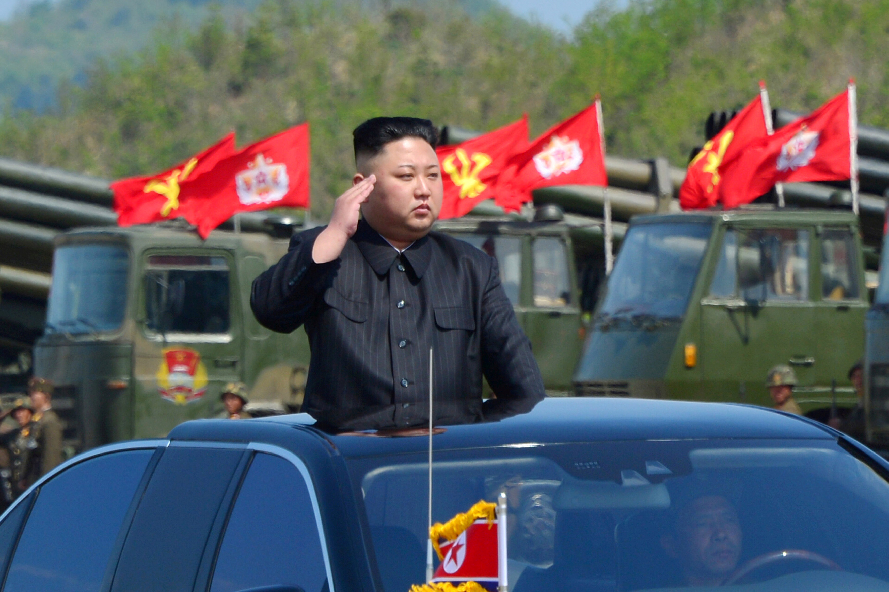
North Korea's leader Kim Jong Un inspects artillery launchers ahead of a military drill marking the 85th anniversary of the establishment of the Korean People's Army

FILE PHOTO: North Korea’s leader Kim Jong Un inspects artillery launchers ahead of a military drill marking the 85th anniversary of the establishment of the Korean People’s Army (KPA) on April 25, 2017. KCNA/File Photo via REUTERS

Currently, the continental United States is primarily shielded by the Ground-based Midcourse Defense system (GMD) in Alaska and California as well as the Aegis system deployed aboard U.S. Navy ships. The THAAD system has a far higher testing success rate than the GMD.

The MDA told Congress in June that it planned to deliver 52 more THAAD interceptors to the U.S. Army between October 2017 and September 2018, bringing total deliveries to 210 since May 2011.

North Korea’s latest missile test puts the U.S. capital within range, but Pyongyang still needs to prove it has mastered critical missile technology, such as re-entry, terminal stage guidance and warhead activation, South Korea said on Friday.


(Reporting by Mike Stone in Simi Valley, Calif.; Editing by Chris Sanders, Michelle Price and Michael Perry)


Irma knocks out power to nearly 6 million: authorities

A lifeguard hut is pictured as Hurricane Irma arrives in Hollywood, Florida. REUTERS/Carlo Allegri

By Scott DiSavino

(Reuters) – Hurricane Irma knocked out power to about 5.8 million homes and businesses in Florida, even as the storm weakened as it crept up the state’s west coast, according to state officials and local electric utilities.

Irma hit Florida on Sunday morning as a dangerous Category 4 hurricane, the second-highest level on the five-step Saffir-Simpson scale. It gradually lost strength and weakened to a tropical storm by Monday morning as it headed toward Georgia, the U.S. National Hurricane Center said at 8 a.m. EDT (1200 GMT)..

Maximum sustained winds were at 70 miles (110 km) per hour, the forecaster said.

Power losses in Georgia, which were at about 152,000 as of 8:45 a.m. EDT, were expected to increase as the storm moved north.

In Florida, the state’s biggest electric company said its outages came to more than 3.6 million by 8:30 a.m. on Monday. A total of 4.2 million Florida Power & Light customers have been affected, with about 570,000 getting service restored, mostly by automated devices.

Full restoration of power could take weeks in many areas due to expected damage to FPL’s system, the NextEra Energy Inc unit said.

As the storm pushed north, outage figures were increasing at other large utilities, including units of Duke Energy Corp, Southern Co and Emera Inc.

Duke’s outages jumped to more than 860,000 overnight; the company said they could ultimately exceed 1 million. Emera’s Tampa Electric utility reported 300,000 homes and businesses lost power by Monday morning.

FPL said its two nuclear plants were safe. Both units at its Turkey Point facility, located about 30 miles (48 km) south of Miami, were shut by early Monday.

The company closed Turkey Point’s Unit 3 on Saturday as Irma approached the coast but decided not shut Unit 4 at that time because the hurricane track shifted away from the plant toward the western part of the Florida Peninsula. FPL, however, shut Unit 4 on Sunday night due to a possible valve issue that was probably not related to Irma, U.S. Nuclear Regulatory Commission officials said on Monday.

At its St Lucie nuclear plant located about 120 miles (190 km) north of Miami, FPL started to reduce power at Unit 1 due to salt buildup from Irma in the switchyard, NRC spokesman Roger Hannah said. The plant’s other reactor, Unit 2, continued to operate at full power.

Duke’s retired Crystal River plant, about 90 miles (145 km) north of Tampa, has spent nuclear fuel, but Hannah said that was not a problem.

As the storm loomed and came ashore, gasoline stations struggled to keep up as people evacuated Florida. In the Atlanta metropolitan area, about 13.2 percent of stations were out of the fuel, according to information service Gas Buddy.

Irma is expected to sap demand for fuel for a time, Goldman Sachs analysts said in a note on Monday, but they cautioned that supply could remain strained due to refining capacity offline in the wake of Hurricane Harvey, which hit Texas two weeks ago.


(Reporting by Scott DiSavino and Jessica Resnick-Ault in New York; Additional reporting by Ruthy Munoz in Houston; Editing by Frances Kerry and Lisa Von Ahn)


Windy, dry weather forecast in U.S. West, threatens to stoke wildfires

A USFS bulldozer cuts a line through vegetation to create a safety line below West Camino Cielo while fighting the Whittier Fire near Santa Barbara, California, U.S. July 15, 2017. Mike Eliason/Santa Barbara County Fire Department/Handout via REUTERS

(Reuters) – More than 800,000 residents in the U.S. West were told to be ready to evacuate on Tuesday as windy, dry conditions threatened to stoke wildfires, forecasters said.

A red flag warning was issued for southern Oregon, northern California and northern Nevada as 35 mph (55 kph) wind gusts and humidity hovering around 10 percent were seen, the National Weather Service said in an advisory.

“Strong winds could rapidly push fire into close proximity of local communities Tuesday afternoon and evening. Heed any evacuation orders. React quickly, you may not have much time to leave,” the service said.

More than a half a dozen fires have started up over the last two days in California including the Detwiler Fire, which forced some residents in Mariposa County to evacuate on Monday.

The fire destroyed one structure and threatened 300 more after swelling to 11,200 acres since it began burning brush and tall grass on Sunday afternoon. Five percent of the fire was contained as of Monday night, the Cal Fire website reported.

“I haven’t seen these conditions in a long time, it’s a wind driven, slope driven, fuel-driven fire,” Jerry Fernandez with Cal Fire told an ABC affiliate in Fresno.

Ten new large blazes ignited on Monday as a total of 35 wildfires burned across the U.S. West, the National Interagency Coordination Center said.

Flames have charred more than twice as much land in California so far in 2017 compared with the same time last year, according to Cal Fire.

(This story has been refiled to delete extraneous word in headline.)

(Reporting by Brendan O’Brien in Milwaukee; Editing by Richard Balmforth)