Dozens rescued from Oklahoma floods as storms swamp central U.S.: officials

A tornado spins during stormy weather in Mangum, Oklahoma, U.S., May 20, 2019, in this still image taken from video from social media. Clint Lively via REUTERS

By Rich McKay

(Reuters) – Dozens of people were rescued from rising waters and felled trees that smashed homes and blocked roadways in Oklahoma, as severe storms generating tornadoes and heavy rain roared through central United States on Tuesday.

Rescue crews in boats pulled at least 50 people from flood waters as heavy downpours inundated roads and homes, said Oklahoma Emergency Management Agency spokeswoman Keli Cain. There were no immediate reports of serious injuries, she said.

Only the tops of cars engulfed by water were visible on roadways near Oklahoma City, and some houses were entirely surrounded by floods, video footage of the location showed.

“It’s real dangerous,” said Ross Reuter, a spokesman for Canadian County, where 10 people were rescued. “Motorists get out into the swift water, thinking they can get across and it ends up being deeper than they think.”

Parts of the state have received six to eight inches (15-20 cm) of rain since Monday, and some 4 million people remained under a flash flood warning or watch in the region, the National Weather Service said.

A twister that touched down early on Tuesday near Tulsa International Airport was among more than two dozen that have ripped through the region since Monday, according to the NWS.

“We have lots of reports of damage coming in. There is a lot of tree damage. Very large trees have been uprooted that are blocking roads and that have landed on houses,” said Sarah Corfidi, an NWS meteorologist.

The NWS said 22 million people were in the path of the severe weather system that was expected to move across Texas and Louisiana, into Alabama and as far north as Iowa and Nebraska all day and into the night on Tuesday.

On Monday, the NWS said the risk of tornadoes in the region was higher than at any time in years.

A new storm system was brewing and could hit the same southern states later this week.

“The whole area is in the bull’s eye, with more rounds of severe storms possible,” the forecaster said.

(Reporting by Rich McKay in Atlanta and Brendan O’Brien in Milwaukee; Editing by Scott Malone, Jeffrey Benkoe and Bernadette Baum)

Hurricane Lane lashes Hawaii with heavy rain, winds

A chicken hops through floodwaters in Hilo, Hawaii, U.S. August 23, 2018, in this still image from video obtained from social media. Kehau Comilla/via REUTERS

By Jolyn Rosa

HONOLULU (Reuters) – Hurricane Lane, a powerful Category 3 storm, lashed Hawaii on Thursday with high winds and torrential rain, causing flash floods, landslides and raging surf as residents hunkered down to ride out the storm.

The storm spun in the Pacific Ocean about 165 miles (260 km) southwest of Kailua-Kona and nearly 20 inches (51 cm) of rain had fallen on the eastern side of the Big Island of Hawaii, the National Weather Service (NWS) said.

“There’s lots and lots of rain, torrential rain, with a lot of moisture in the atmosphere,” NWS meteorologist Chevy Chevalier said, noting there were reports of 50 miles per hour (80 km/h) wind gusts. “We’re in it now.”

There were no reports of injuries, but roads were closed because of flash floods and landslides in the Pacific island state. Tourists were advised to stay away from a popular attraction on the island of Maui called the Seven Sacred Pools, a scenic cluster of waterfalls and grottos.

“Life threatening flash floods. This is a very dangerous situation. Avoid unnecessary travel,” Governor David Ige said on Twitter.

Evacuations were underway on parts of Molokai and Maui islands while power outages were being reported on social media.

The latest predictions showed the eye of the storm twisting west of the Big Island on Friday morning before glancing past Maui and several other islands later in the day on its way to Oahu. But authorities warned the islands could still expect to be hit hard.

Lane shifted from heading northwest and was headed north at 6 miles per hour as the Category 3 storm on the five-step Saffir-Simpson scale was packing winds of 120 mph (195 kph), the service said in an evening advisory.

“We’re telling everybody to take the storm seriously, make your final preparations, and be prepared to ride out what is going to be a prolonged rain event,” said Andrew Pereira, communications director for the city and county of the state capital Honolulu.

Incoming waves tower over bystanders in Kona, Hawaii, U.S. August 23, 2018 in this still image from video obtained from social media. Ryan Leinback/via REUTER

Incoming waves tower over bystanders in Kona, Hawaii, U.S. August 23, 2018, in this still image from video obtained from social media. Ryan Leinback/via REUTERS

REMEMBERING INIKI

The National Hurricane Center warned storm surges could raise water levels 3 to 5 feet (1 to 1.5 meters) above normal along the western shores of the Big Island and that extreme rainfall could mean “numerous evacuations and rescues.”

Ige has urged residents to set aside a 14-day supply of water, food, and medicine. All public schools, University of Hawaii campuses and non-essential government offices on the islands of Oahu and Kauai were closed at least through Friday.

“We are in our room at Alohilani Resort waiting for Hurricane Lane to arrive,” said Janina Ballali on Twitter. “Hopefully, the hurricane will have mercy with our beloved Oahu.”

Par Pacific Holdings Inc said it had shut its 93,500 barrel-per-day refinery in Kapolei due to the storm.

In Hanalei on Kauai, rain fell Thursday as residents and businesses prepared for the hurricane while tourists continued to shop and dine in places that were still open.

Dave Stewart, owner of Kayak Hanalei, had boarded up the windows on his shop by mid-afternoon and moved the company’s rental kayaks to high ground.

He said he wasn’t taking any chances, having lived through severe flooding on Kauai’s North Shore in April and through Hurricane Iniki in 1992.

“That was total destruction,” he said of Iniki. “Seven out of 10 telephone poles were down, so even if your house was OK, you couldn’t get out.”

Iniki was the most powerful hurricane on record to hit Hawaii, making landfall on Kauai island on Sept. 11, 1992, as a Category 4. It killed six people and damaged or destroyed more than 14,000 homes.

The shelves of a downtown Honolulu Walmart were stripped of items ranging from canned tuna to dog food, bottled water and coolers full of ice.

Video footage showed whipping palm trees and darkening skies in Maui. In the Manoa Valley neighborhood in Honolulu, sidewalks typically full of joggers and dog walkers were empty as residents stood outside their homes watching the skies and businesses closed early for the day.

President Donald Trump declared a state of emergency for Hawaii and ordered federal authorities to help supplement state and local responses, the White House said on Thursday.

The Coast Guard has ordered all harbors to close to incoming vessels and the U.S. Navy moved most of its fleet out of Pearl Harbor, where ships could provide aid after the storm.

Since Hurricane Maria devastated Puerto Rico last year, the Federal Emergency Management Agency has made changes to how it works, FEMA Administrator Brock Long said at a briefing in Washington, making sure generators are in place so they can provide power to residents and quickly restart the water system.

“It’s not just providing food and water. If you fix the power first, you solve 90 percent of the problems,” he said.

(Reporting by Jolyn Rosa; Additional reporting by Gina Cherelus in New York, Brendan O’Brien in Milwaukee, Doina Chiacu and Lisa Lambert in Washington and Steve Gorman and Dan Whitcomb in Los Angeles; Writing by Dan Whitcomb; Editing by Janet Lawrence and Raissa Kasolowsky)

Approaching hurricane sparks runs in Hawaii on plywood, water and gasoline

Paul Akamine fills propane tanks for customers as Hurricane Lane approaches Honolulu, Hawaii, U.S. August 22, 2018. REUTERS/Hugh Gentry

By Sue Horton

HANALEI, Hawaii (Reuters) – Micco Godinez, who rents out kayaks on the island of Kauai and loves surfing, said he was twice tempted to hit the waves on Wednesday but kept his focus on a more pressing concern – getting ready to board up his home for a major hurricane.

With forecasts calling for Hurricane Lane to strike or brush past Hawaii’s “Garden Isle” on Friday, Godinez, 66, has joined tens of thousands of others on Kauai, and across the state, in the rituals of disaster preparation.

A long line of cars wait as people fill up their vehicles with gasoline as Hurricane Lane approaches Kauai, Hawaii, U.S., August 22, 2018. REUTERS/ Sue Horton

A long line of cars wait as people fill up their vehicles with gasoline as Hurricane Lane approaches Kauai, Hawaii, U.S., August 22, 2018. REUTERS/ Sue Horton

Lane, wavering between Category 4 and Category 5 strength on the five-step Saffir-Simpson hurricane scale, churned toward the U.S. Pacific island state with sustained winds of up to 155 miles per hour (250 kph) on Wednesday, as authorities urged residents to stock up on water, food and medicines.

Across Hawaii, jittery residents lined up at hardware centers, gasoline stations and grocery stores. But nowhere was the sense of urgency perhaps more palpable than on Kauai, where torrential rains four months ago triggered widespread flooding that destroyed homes and washed out roads.

“Some people here were just wiped out in that flood. It rained 50 inches (127 cm) in 24 hours,” said Hanalei resident Charlie Cowden, who owns several surf shops on the island. “Now there is this.”

Many older residents recalled even greater devastation from the last Category 4 storm to pummel Hawaii, Hurricane Iniki, which made landfall on Kauai in September 1992, killing six people and leveling or damaging more than 14,000 dwellings.

Luke Yamanuha loads plywood into his truck as Hurricane Lane approaches Honolulu, Hawaii, U.S. August 22, 2018. REUTERS/Hugh Gentry

Luke Yamanuha loads plywood into his truck as Hurricane Lane approaches Honolulu, Hawaii, U.S. August 22, 2018. REUTERS/Hugh Gentry

‘SLIM PICKINGS’

Godinez, who lives two blocks from the ocean in the bayside town of Hanalei on Kauai’s north shore, said he spent part of his day shopping for lumber and a recharging device for his portable drill.

He described the mood in town as “pleasantly apprehensive” and said he even felt the familiar pang of one of his favorite pastimes. “Twice the surf was up, and twice I wanted to go surfing, but I had other things pressing on my mind.”

He recalled getting up early to drive to a Home Depot building-supply outlet before it opened at 6 a.m., only to find two dozen others already lined up ahead of him.

“There’s a run on plywood,” he said. “It was slim pickings when I was there.”

Pausing later after filling up jugs of water, Godinez said he and his wife would spend the rest of the day taking measurements and cutting plywood to fit over more than 18 windows on their two-story house.

“Measure twice, cut once, and away we go,” he said, adding they would wait until Thursday for the latest forecasts before deciding whether to go ahead with fastening the boards to the windows.

Since Hanalei is on the opposite side of Kauai from where the hurricane is most likely to come ashore, Godinez said he was less concerned about ocean storm surge than ferocious winds.

Godinez said he, his wife and two guests planned to “hunker down” in a first-floor laundry room at the height of the storm, should it make landfall by late Thursday or early on Friday.

With two small laundry windows sealed up and probably no electricity, except for battery-powered flashlights, “It’s going to be hot and dark,” he said.

(Reporting by Sue Horton; Additional reporting and writing by Steve Gorman in Los Angeles; Editing by Bill Tarrant and Peter Cooney)

Heavy rains due to drench Texas Gulf Coast, Midwest

6-20-18 National Weather Service precipitation map

(Reuters) – Heavy downpours were expected to drench the Gulf Coast of Texas and the U.S. Midwest on Wednesday and could cause flooding especially along already swollen rivers and in low-lying areas, forecasters warned.

Up to 5 inches (13 cm) of rain was forecast for parts of the Texas coast along the Gulf of Mexico and in the Middle Mississippi Valley states of South Dakota, Nebraska, Iowa and Kansas throughout the day and into Thursday, the National Weather Service (NWS) said.

“Be prepared for water over roads due to rapid rises on creeks and streams or even water flowing from farm fields,” the NWS in Des Moines, Iowa, said in an advisory.

Authorities closed roadways early Wednesday in several communities along the Des Moines and Mississippi rivers in the Midwest where intense rains have already fallen over the last few days, according to the NWS.

Showers and thunderstorms were also expected for Rockford, Illinois, where five inches of rain fell in less than four hours on Monday night. Emergency crews rescued people from numerous submerged vehicles.

In Corpus Christi, Texas, where more than 2 inches of rain was forecast after more than a foot of rain has fallen, crews conducted several high-water rescues on Tuesday while police closed roadways, local media reported.

(Reporting by Brendan O’Brien in Milwaukee; Editing by Jeffrey Benkoe)

Greece to give millions in compensation to flood victims

Greece to give millions in compensation to flood victims

ATHENS (Reuters) – Greece said on Monday it would offer emergency compensation worth millions of euros to hundreds of households affected by flash flooding west of Athens that killed at least 20 people on Nov. 15.

Hundreds of homes and businesses were extensively damaged in the coastal towns of Mandra and Nea Peramos when a torrent of mud and water smashed into the settlements, built along dry gullies on the foothills of a mountain range.

Twenty people died and two remain missing from the early-morning deluge, the worst casualty toll from flooding since 1977 when more than 30 people died.

The disaster has prompted recriminations and finger-pointing over a perceived inability of Greek authorities to act on prior warnings that areas with poor infrastructure and unlicensed construction were vulnerable to flooding. Critics also asked why flood prevention projects had been delayed.

Authorities will offer flood victims up to 5,000 euros ($5,896.50) for households and 8,000 euros for businesses, government spokesman Dimitris Tzanakopoulos said.

It was not immediately clear how much the state had budgeted for compensation. Tzanakopoulos told Reuters the amount would come from the national budget.

That assistance would be over and above compensation residents were entitled to, comprised of 60 percent government aid and 40 percent interest-free loan, he said.

The flash flooding hit many areas of the country, including housing settlements where town planning regulations are often flouted.

(Reporting by Michele Kambas; editing by Mark Heinrich)

Flood threat rises as Harvey dumps torrential rains on Texas

A storm chaser films himself on a camera phone as Hurricane Harvey approaches, on the boardwalk in Corpus Christi, Texas. REUTERS/Adrees Latif

By Brian Thevenot

ROCKPORT, Texas (Reuters) – The most powerful hurricane to hit the U.S. state of Texas in more than 50 years moved slowly inland on Saturday, dumping torrential rain expected to cause catastrophic flooding after battering the coast with 130 miles per hour (209 km per hour) winds.

Texas utility companies said just under a quarter of a million customers were without power. Wind and rain continued to lash the coast as residents began to assess the damage.

Harvey is the strongest storm to hit Texas, the center of the U.S. oil and gas industry, since 1961.

The seaside town of Rockport, 30 miles (48 km) north of the city of Corpus Christi, was hit hard.

Several homes had collapsed, and many more buildings suffered damage. Roofs had been ripped off some, and windows blown in.

The streets were flooded and strewn with power lines and debris. At a recreational vehicle sales lot, a dozen vehicles were flipped over and one had been blown into the middle of the street outside.

“It was terrible,” resident Joel Valdez, 57, told Reuters. The storm ripped part of the roof from his trailer home at around 4 a.m., he said. “I could feel the whole house move.”

Valdez said he stayed through the storm to look after his animals.

“I have these miniature donkeys and I don’t know where they are,” he said, as he sat in a Jeep with windows smashed by the storm.

Resident Frank Cook, 56, also stayed through the storm.

“If you have something left of your house, you’re lucky,” he said, surveying the damage from his vehicle.

Before the storm hit, Rockport’s mayor told anyone staying behind to write their names on their arms for identification purposes in case of death or injury.

A high school, hotel, senior housing complex and other buildings suffered structural damage, according to emergency officials and local media. Some were being used as shelters.

The coastal city of Port Lavaca, farther north on the coast, had no power and some streets were flooded.

“There is so much tree damage and debris that the cost of cleanup will be enormous,” Mayor Jack Whitlow told Reuters, after touring the city earlier Saturday.

The hurricane came ashore near Port Lavaca late on Friday with maximum winds of 130 mph (209 km/h). That made it a Category 4 storm on the Saffir-Simpson scale, the second-highest category and the most powerful storm in over a decade to hit the mainland United States.

The streets of Corpus Christi, which has around 320,000 residents, were deserted early on Saturday, with billboards twisted and strong winds still blowing.

City authorities asked residents to reduce use of toilets and faucets because power outages left waste water plants unable to treat sewage.

The city also asked residents to boil water before consumption.

A drill ship broke free of its mooring overnight and rammed into some tugs in the port of Corpus Christi, port executive Sean Strawbridge said. The crews on the tugs were safe, he added.

The city was under voluntary evacuation ahead of the storm.
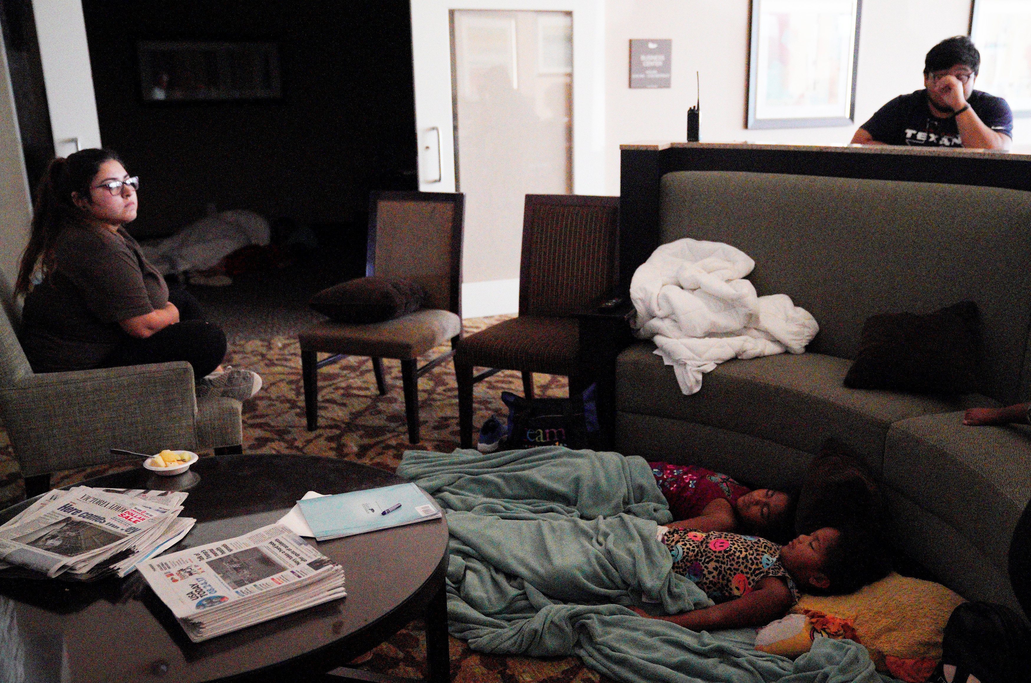
Children sleep in a hotel lobby waiting out Hurricane Harvey in Victoria, Texas, August 26, 2017. REUTERS/Rick Wilking

Children sleep in a hotel lobby waiting out Hurricane Harvey in Victoria, Texas, August 26, 2017. REUTERS/Rick Wilking

HEADING INLAND, STORM WEAKENS

The storm weakened to Category 1 early on Saturday and was expected to be downgraded to a tropical storm later in the day, the U.S. National Hurricane Center said. Harvey was about 150 miles (241 km) west-southwest of Houston, moving at about 2 mph (4 km/h), the center said in a morning update.

Harvey was expected to linger for days over Texas and bring as much as 40 inches (101.6 cm) of rain to some parts of the state.

The latest forecast storm track has Harvey looping back toward the Gulf of Mexico coast before meandering north again on Tuesday. (http://tmsnrt.rs/2g9jZ0W)

Nearly 10 inches (25 cm) of rain had already fallen in a few areas in southeastern Texas, the center said. Flash floods have already hit some areas, the National Weather Service said.

As many as 6 million people were believed to be in Harvey’s path, as is the heart of America’s oil-refining operations. The storm’s impact on refineries has already pushed up gasoline prices. The U.S. Environmental Protection Agency eased rules on gasoline specifications late on Friday to reduce shortages.

U.S. President Donald Trump, facing the first big natural disaster of his term, said on Twitter he signed a disaster proclamation that “unleashes the full force of government help” shortly before Harvey made landfall.

“You are doing a great job – the world is watching,” Trump said on Saturday in a tweet referring to the Federal Emergency Management Agency (FEMA), which coordinates the response to major disasters.

Utilities American Electric Power Company Inc and CenterPoint Energy Inc reported a combined total of around 237,000 customers without power.

While thousands fled the expected devastating flooding and destruction, many residents stayed put in imperiled towns and stocked up on food, fuel and sandbags.
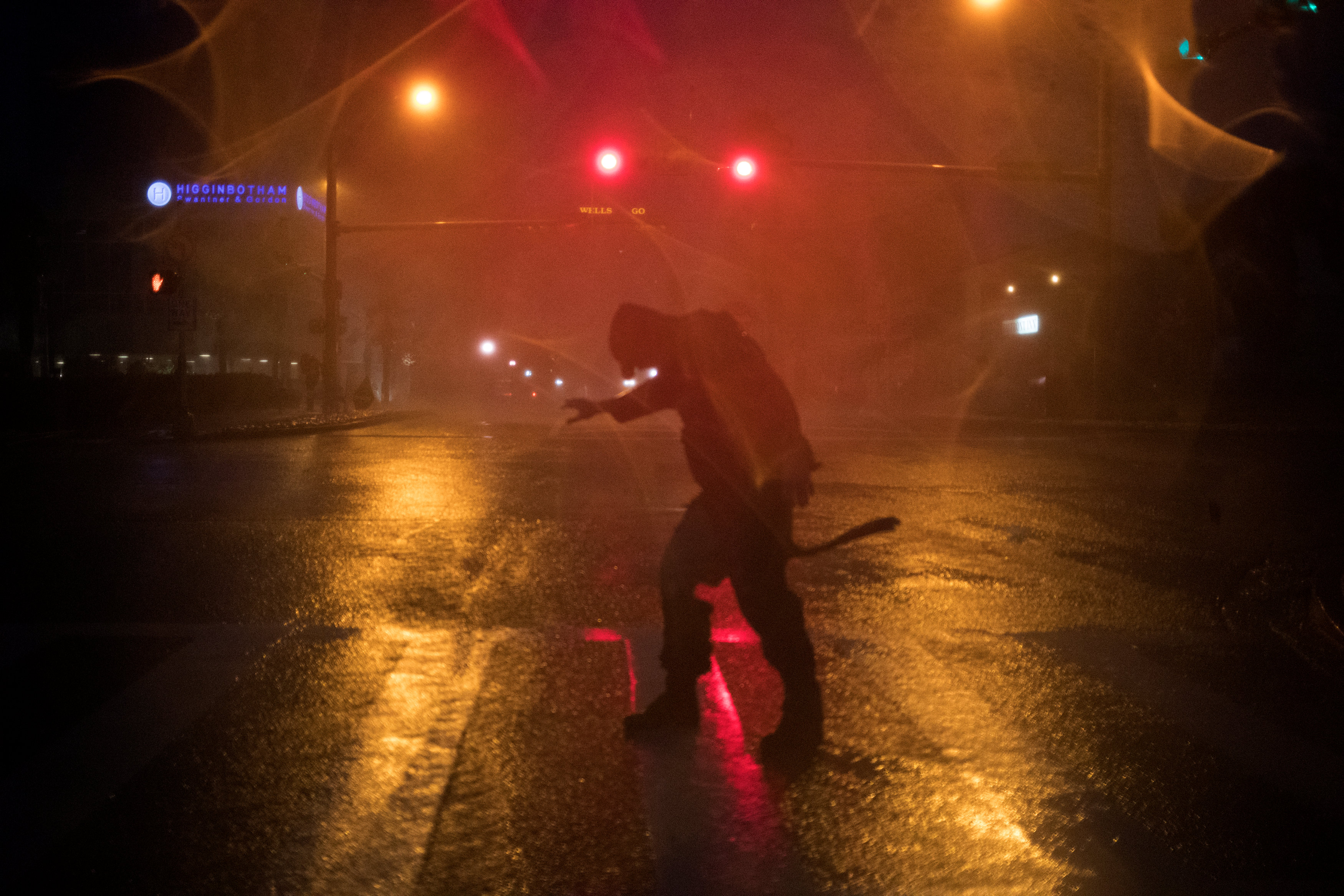
Stewart Adams, of San Marcos, Texas, plays in the winds from Hurricane Harvey in Corpus Christi, Texas, U.S. August 25, 2017. REUTERS/Adrees Latif

Stewart Adams, of San Marcos, Texas, plays in the winds from Hurricane Harvey in Corpus Christi, Texas, U.S. August 25, 2017. REUTERS/Adrees Latif

HOUSTON PREPARES FOR FLOODS

The size and strength dredged up memories of Katrina, the 2005 hurricane that made a direct hit on New Orleans as a Category 3 storm, causing levees and flood walls to fail in dozens of places. About 1,800 died in the disaster made worse by a slow government emergency response.

Texas and Louisiana declared states of disaster before Harvey hit, authorizing the use of state resources to prepare.

Residents of Houston, the nation’s fourth most populous city, were awakened early on Saturday by automatic cell phone warnings of flash floods.

The city warned of flooding from close to 20 inches (60 cm) of rain over several days.

A collapsed overhead gantry lies across Interstate 37, blocking the highway due to damage caused by Hurricane Harvey in Corpus Christie, Texas, U.S., August 26, 2017.   REUTERS/Mohammad Khursheed?

A collapsed overhead gantry lies across Interstate 37, blocking the highway due to damage caused by Hurricane Harvey in Corpus Christie, Texas, U.S., August 26, 2017. REUTERS/Mohammad Khursheed?

GASOLINE PRICES SPIKE

U.S. gasoline prices spiked as the storm shut down several refineries and 22 percent of Gulf of Mexico oil production, according to the U.S. government. Many fuel stations ran out of gasoline before the storm hit.

More than 45 percent of the country’s refining capacity is along the U.S. Gulf Coast, and nearly a fifth of the nation’s crude is produced offshore.

Ports from Corpus Christi to Texas City, Texas, were closed to incoming vessels and Royal Dutch Shell Plc, Anadarko Petroleum Corp, Exxon Mobil Corp and others have evacuated staff from offshore oil and gas platforms.

Disruptions to fuel supply drove benchmark gasoline prices to their highest level in four months.

The U.S. government said it would make emergency stockpiles of crude available if needed to plug disruptions. It has regularly used them to dampen the impact of previous storms on energy supplies.
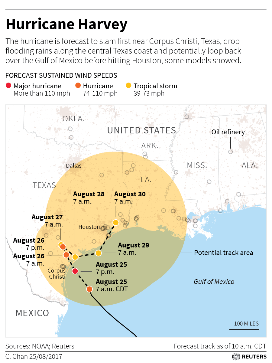
For a graphic on Hurricanes in the North Atlantic, click tmsnrt.rs/2gcckz5

(Additional reporting by Jessica Resnick-Ault in New York, Liz Hampton, Ernest Scheyder and Gary McWilliams in Houston; Writing by Brendan O’Brien and Simon Webb; Editing by Helen Popper and Matthew Lewis)

Search for Arizona man after flash flood kills 9 of his family

By David Schwartz

PHOENIX (Reuters) – Authorities searched on Monday for a missing man after a flash flood crashed down an Arizona canyon, law enforcement officials said, reportedly killing his wife and eight other family members at a popular swimming spot north of Phoenix.

Searchers scoured an area of the Tonto National Forest for an unidentified 27-year-old man who officials said was among 14 members of an extended family hit by a wall of flood water on Saturday afternoon.

Nine of the family, ranging in age from 2 to 57, died in the floodwaters on Saturday afternoon, according to a statement on Monday from the Gila County Sheriff’s Department.Four others from the Phoenix family, aged between 1 and 29, were rescued and survived the incident.

The Arizona Republic newspaper identified the missing man as Hector Miguel Garnica and said that the dead included Garnica’s wife, Maria Raya, 25, and her three children, Emily, 3, Mia, 5, and Hector Daniel, 7. Also killed was Selia Garcia, who authorities said was 57 and whom the Republic identified as Raya’s mother.

The group of 14 was swept down the creek after a thunderstorm hit about eight miles away in an area that had been burned by a nearly 7,200-acre wildfire last month, according to authorities.

Officials with the National Weather Service said one to 1.5 inches fell in 20 to 30 minutes in the area near Payson, about 90 miles (145 km) northeast of Phoenix.

A video posted on social media showed a muddy, debris-filled torrent that hit Ellison Creek, rushing down a narrow canyon where the swimmers were taking in the cool waters at the popular spot.

Three bodies were recovered on Saturday, with the other six recovered on Sunday, officials said.

Forecasters said they were concerned about additional possible flash flooding projected for central and southern Arizona.

The National Weather Service in Phoenix said that most of Arizona was under flash flood watch until Monday evening, warning that the monsoon air mass over the region was very wet and conducive to heavy thunderstorm rain that could lead to flood or flash flooding.

(Reporting by David Schwartz, additional reporting by Taylor Harris; Editing by Andrew Hay and Patrick Enright)

Tropical Depression Cindy still packs a punch after landfall on Thursday

Radar from the continued threat of Tropical Storm Cindy

By Kami Klein

In the wake of the landing of Tropical Depression Cindy, there is extensive flooding in many states, the death of a 10 year old boy from debris in Fort Morgan, Alabama  as well as the damage and injuries from an F2 tornado that plowed through Birmingham, Alabama on Thursday,  From reports by the National Weather Service, this was just the beginning of problems that will be arising from this intense storm system.   

The F2 Tornado that hit a heavily populated area in Birmingham, Alabama Thursday afternoon left extensive structural  damage and injured four people. The Weather Channel also reported that Mayor Tim Kerner of the town of Lafitte, Louisiana (located south of New Orleans) said the rising water may impact homes and vehicles, and he issued a voluntary evacuation for all residents.

The AP has reported that more than a foot of rain has fallen in Ocean Springs, Mississippi. Residents are concerned with the damages and hazards brought by the immense amount of water, including the dangers of alligators that are prevalent in many ponds and will now move into more populated areas.  

Mississippi residents are not the only people concerned about frightening impacts in nature caused by the flooding. The Alabama Cooperative Extension System warned of floating colonies of fire ants in the flood waters.  In a statement, the agency said the fire ants may resemble ribbons, streamers or large balls of ants floating on the water and that residents should be on the lookout when maneuvering in or being near flooded areas.

So far the states of Louisiana, Mississippi, Alabama, Texas, Tennessee and even southern Arkansas have been affected by the torrential rains contained in Tropical Depression Cindy.  Officials in all states have warned that there is a strong possibility for more flash flooding and tornadoes.  

In a report by The Weather Channel, remnants of the storm moved into Tennessee on Friday, knocking down trees and prompting power outages. According to Memphis Light Gas and Water, nearly 10,000 customers were without power Friday morning. Kentucky and West Virginia are bracing themselves for Heavy rainfall and flooding and reports from the weather service show that portions of Michigan and Indiana are also being affected by this storm system as well.  

The National Weather Service says that the path of Tropical Storm Cindy will spread heavy rain into the Tennessee and Ohio Valleys today – and into the Appalachians and Mid-Atlantic tonight. Flash flooding is possible in these areas as well as strong to severe thunderstorms.  


Thai floods cause 200-kilometer traffic tailback; death toll up to 25

Bridge damaged by floods in Thailand

BANGKOK (Reuters) – Flash floods in southern Thailand washed out a bridge on the country’s main north-south highway on Tuesday, backing up traffic for 200 km (125 miles) as the death toll from days of unseasonable rain rose to 25, media reported.

More than 360,000 households, or about a million people, have been affected by the floods that have damaged homes and schools and affected rubber and palm oil production, the Department of Disaster Prevention and industry officials said.

Television pictures showed abandoned cars submerged in murky waters in Prachuap Khiri Khan province where a torrent washed out a bride on the main road linking Bangkok to the south, causing the 200 km tailback, media reported.

The railway link to the south, and Malaysia, beyond has been severed for days.

Thailand’s rainy season usually ends in late November but this year heavy rain has fallen well into what should be the dry season.

Southern Thailand is a major rubber-producing area and the wet weather has hit production. Palm oil plantations have also been flooded, industry officials and farmers’ groups said.

In Nakhon Si Thammarat, one of the worst-hit provinces, television footage showed villagers commuting by boat.

“It’s like a big pond,” said resident Pattama Narai.

Nakhon Si Thammarat has had 493 mm of rain in the past seven days, 426 mm more than the average for this time of year, according to Thomson Reuters data.

Flooding regularly occurs in the May-November rainy season.

In 2011, widespread flooding that began in the north and flowed down to Bangkok crippled industry, killed more than 900 people and slowed economic growth to just 0.1 percent that year.

(Reporting by Amy Sawitta Lefevre, Juarawee Kittisilpa and Jutarat Skulpichetrat; Editing by Robert Birsel; Writing by Amy Sawitta Lefevre; Editing by Robert Birsel)

Historic town swamped, 22 dead in North Carolina flooding

Flooded motor homes

By Jonathan Drake

TARBORO, N.C. (Reuters) – Floodwaters inundated the historic black town of Princeville, North Carolina, on Thursday, leaving homes submerged to their roof lines as the state’s death toll in the aftermath of Hurricane Matthew climbed to 22.

Flooding from the Tar River had been expected in Princeville, which was founded in 1885 and believed to be the oldest U.S. town incorporated by freed slaves, and most of its 2,000 residents evacuated.

North Carolina Governor Pat McCrory described a dramatic rise in the water level in the town, long been plagued by flooding and devastated by floods after Hurricane Floyd in 1999.

Areas that had about a foot of water on Thursday morning were covered in up to 12 feet by afternoon, he said.

“Princeville is basically under water at this time,” McCrory told a news conference after flying over the town. “You gotta see it to believe it.”

The governor praised the town’s residents for heeding evacuation orders, saying no one there had died.

However, McCrory announced two additional fatalities after the storm death toll rose to 20 late on Wednesday. The latest victims included someone who drowned in Lenoir County after driving around a barricade for a washed-out roadway. Most of the state’s deaths from the hurricane have been drownings, he said.

“Stay off the roads,” McCrory said. “Stay out of the water.”

More than 30 deaths in the United States have been blamed on Matthew, with a fourth death announced in South Carolina by that state’s governor on Thursday. Before hitting the southeast U.S. coast, the fierce storm killed around 1,000 people on its rampage through Haiti last week.

The recovery effort in central and eastern North Carolina is expected to take weeks or months. So far, the federal government has disbursed about $2.6 million to individual flooding victims and approved $5 million for emergency road repairs.

(Additional reporting and writing by Colleen Jenkins; Editing by Tom Brown)