Several tornadoes spotted and warnings of isolated hail ahead of category 5 Hurricane Milton

Tornado ahead of Hurricane Milton

Important Takeaways:

  • The National Weather Service (NWS) in Miami has issued a tornado watch and several tornado warnings for parts of Florida as Hurricane Milton rapidly approaches west-central Florida.
  • On Wednesday morning, the NWS reported several tornadoes, including one crossing the I-75 highway, and urged residents to seek shelter immediately.
  • The tornado watch remains valid until Wednesday evening at 9pm ET and covers parts of south Florida
  • Videos and pictures posted online showed several of the spotted tornadoes growing in size as they move across south Florida.
  • The agency also warned that isolated hail up to a 0.5in size is possible, along with isolated gusts of wind traveling up to 70mph.
  • Approximately 12.6 million residents face potential exposure to the tornadoes, in addition to 2,424 schools and 170 hospitals.
  • The tornado watch and warnings come as the category 5 Hurricane Milton is expected to double in size as the “storm of the century” by the time it makes landfall late Wednesday or early Thursday.

Read the original article by clicking here.

Updates on Texas wildfires

Smokehouse-Creek-Fire-damage

Important Takeaways:

  • Texas wildfires map: Track latest locations of blazes as dry weather, wind poses threat
    • Texas wildfires have been burning for 5 days
    • The wildfires were ignited in the panhandle on Monday Feb. 26. The flames continued to spread throughout the state as dry, warm and windy weather conditions created obstacles for rescue crews to contain the fire.
    • The Smokehouse Creek Fire, about 60 miles northeast of Amarillo, is the largest reported fire in state’s history and has burned over a million acres of land.
    • Where are the Texas wildfires?
    • 687 Reamer — Hutchinson County, 2,000 acres, 10% contained
    • Grape Vine Creek — Gray County, 30,000 acres, 60% contained
    • Magenta — Oldham County, 3,297 acres, 85% contained
    • Smokehouse Creek — Hutchinson County, 1,078,086 acres, 60% contained
    • Windy Deuce — Moore County, 142,000 acres, 60% contained

Read the original article by clicking here.

Storm hits Florida with torrential downpour and 74mph winds knocking out power for 120,000

Palm-Beach-flooding

Important Takeaways:

  • ‘Hurricane equivalent’ winds and torrential rains leave more than 120,000 without power in Florida as more than 7million are under flood watch
  • Nearly 120,000 homes in Florida are without power after ‘hurricane’ level winds and torrential rain hit the state overnight.
  • Thousands of people have woken up in the dark across Miami-Dade, Broward and Palm Beach amid hurricane-force winds, with over 7 million people under flood watch.
  • The National Weather Service has called the wind speeds recorded in some of these areas ‘hurricane equivalent’, as they topped 74mph.
  • In an advisory, they said: ‘Damaging winds will blow down trees and power lines. Widespread power outages are expected.’
  • Forecasters have said that rainfall today will likely reach five to eight inches across Miami and the Fort Lauderdale areas of South Florida, with some areas being hit with 12 inches, according to Fox Weather.
  • Florida Governor Ron DeSantis had to declare a state of emergency as storms caused mass flooding, after they dumped two feet of rain in a matter of hours.

Read the original article by clicking here.

Be prepared as severe thunderstorms and high winds will pack a punch from the plains to the south

Luke 21:25 ““And there will be signs in sun and moon and stars, and on the earth distress of nations in perplexity because of the roaring of the sea and the waves

Important Takeaways:

  • Severe Thunderstorms With Hail, High Winds Possible In Plains, South
  • A threat of severe thunderstorms is back in the nation’s midsection and South this week.
  • Scattered severe thunderstorms are most possible from parts of northeast Kansas into southeast Nebraska, Iowa and northwest Missouri, including a few of the same areas affected by severe storms last Friday.
  • The majority of these storms should flare up early Wednesday evening and night. Large hail is the main threat, with some destructive hail possibly larger than baseballs. Damaging wind gusts and a few tornadoes are also possible.
  • Any storms farther south into the areas shaded in Oklahoma and Texas could be more isolated or might not occur at all during the late afternoon or evening. Large hail and perhaps a strong wind gust are the main concerns if any of these storms can punch through an inhibiting cap.

Read the original article by clicking here.

Californians see Wind, Rain and Mudslides after latest storms pass through

Luke 21:25 ““And there will be signs in sun and moon and stars, and on the earth distress of nations in perplexity because of the roaring of the sea and the waves

Important Takeaways:

  • California reeling from mudslides, wind damage after latest atmospheric river to pummel state
  • Crosswinds blew over trucks and trailers on Bay Area bridges. Authorities closed the Golden Gate Bridge and the Richmond San Rafael Bridge to high-profile vehicles. San Francisco International Airport issued a ground stop for a time because of the extreme gusts.
  • In the Santa Cruz area, two cars were struck by a falling tree as they traveled along busy Highway 1.
  • Gusts reached 80-90 mph in some of the Bay Area foothills, with Loma Prieta registering a gust of 97 mph. Farther inland, Sacramento reported a 60-mph gust.
  • At the height of the storm, some 373,000 customers were without power in California as trees and power lines succumbed to the high winds
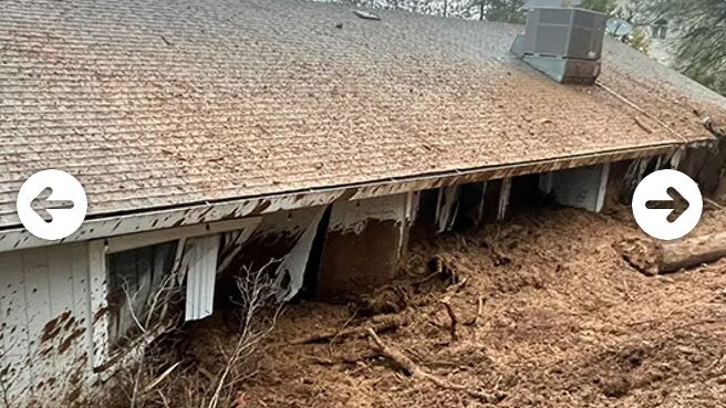
  • In Placer County near the Sierra Nevada, a massive landslide crashed into a home in Colfax, leaving significant mud-covered damage but no injuries.
  • Orange County emergency crews evacuated an apartment building when the cliff holding up the rear of the building collapsed onto the trail below.
  • As night approached, heavier rains spread south into the Los Angeles area, setting eight daily rainfall records across Southern California… a daily record that had stood for 97 years.

Read the original article by clicking here.
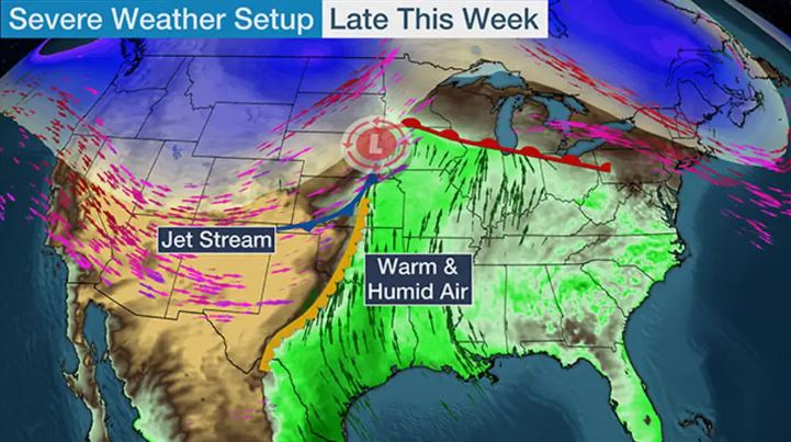
High winds, heavy rain, freezing temperatures as millions brace for another storm

Luke 21:25-26 “And there will be signs in sun and moon and stars, and on the earth distress of nations in perplexity because of the roaring of the sea and the waves, people fainting with fear and with foreboding of what is coming on the world. For the powers of the heavens will be shaken.

Important Takeaways:

  • Calm before yet ANOTHER storm: As millions are reeling from crippling Arctic blast a new storm is brewing bringing MORE snow, flash floods and tornadoes tomorrow
  • 40mph winds, freezing temperatures and two inches of rain forecast statewide
  • 1,800 flights cancelled and 250,000 lost power in cold snap in Texas last week
  • Millions will once more be forced to brace for severe weather conditions as snow, flash floods and a possible tornado are predicted to center on the south and east of the nation.
  • Texas especially is recovering from severe weather conditions that last week put 40 million people from Texas and Oklahoma to Kentucky in the path of the freezing weather and left 250,000 without power.
  • Arctic winds brought temperatures to record lows before the weekend, with a wind-chill value of -108F in New Hampshire and -45F in Maine.
  • Heavy rainfall and localized flash flooding is possible, mainly along and east of I-35.
  • Colder air will bring snow to Kansas, Iowa and Wisconsin on Wednesday before the storm moves east out to the ocean

Read the original article by clicking here.
Fiona pummels Bermuda with 30 foot tidal waves, 125mph winds

Revelation 16:9 “They were scorched by the fierce heat, and they cursed the name of God who had power over these plagues. They did not repent and give him glory.”

Important Information:

  • Hurricane Fiona slams into Bermuda: 125mph winds CAPSIZE yachts, pummel mansions and leave 70% of the island without power
  • Bermuda is being pounded with winds of up to 125 mph and 30 feet tidal swells as Hurricane Fiona continues to devastate the Caribbean islands on its way north
  • The powerful waves have already capsized multiple boats along Hamilton Harbor, and residents are taking shelter in their homes after spending hours boarding up their properties on Thursday
  • The storm is expected to reach northeastern Canada by Saturday, where it can dump between four to eight inches of rain on Nova Scotia, Prince Edward Island and Newfoundland
  • The Category 3 storm has already killed five people — two in Puerto Rico, two in the Dominican Republic and one in the French island of Guadeloupe

Read the original article by clicking here.

Hurricane Isaias heads toward Florida with 75-mph winds – Hurricane Center

By Zachary Fagenson

MIAMI (Reuters) – Heavy rains from Hurricane Isaias could hit Florida late Friday night before the powerful storm moves up the East Coast into early next week, the U.S. National Hurricane Center (NHC) warned, prompting the closure of COVID-19 testing sites.

The hurricane, packing maximum sustained winds of 75 miles (120.7 km) per hour, is currently lashing the southeastern part of the Bahamas and the Turks and Caicos Islands, the Miami-based forecaster posted on its Twitter feed on Friday.

“Heavy rains associated with Isaias may begin to affect south and east-Central Florida beginning late Friday night, and the eastern Carolinas by early next week, potentially resulting in isolated flash and urban flooding, especially in low-lying and poorly drained areas” the NHC said on its website.

Miami-Dade County officials closed drive-through and walk-up testing sites for COVID-19. Public beaches, parks, marinas, and golf courses were also set to close on Friday as Isaias strengthened to a Category 1 hurricane and forecasters predicted it would reach Category 2.

Broward County Mayor Dale V.C. Holness had on Thursday also announced testing sites would close, with plans to reopen on Wednesday morning.

As of Friday morning the storm was predicted to most impact Florida’s central, eastern region before moving north.

At full capacity Florida had 162 test sites in all but two of the state’s 67 counties. Some counties will continue testing through their individual health departments.

“We have thousands of tests that will not be conducted until we get these test sites up and running again,” Miami-Dade County Mayor Carlos Gimenez said in a virtual news conference on Friday morning.

(Reporting by Nathan Layne in Wilton, Connecticut; Editing by Nick Zieminski and Jonathan Oatis)

Mother and child plus two others killed as Florence swamps Carolinas

A fallen tree lies atop the crushed roof of a fast food restaurant after the arrival of Hurricane Florence in Wilmington, North Carolina, U.S., September 14, 2018. REUTERS/Jonathan Drake


By Ernest Scheyder

WILMINGTON, N.C. (Reuters) – Hurricane Florence crashed into the Carolinas on Friday, knocking down trees, swamping streets and causing four deaths before slowing to a pace that will lead to a days-long deluge for the region.

The storm’s first casualties, which included a mother and her baby killed when a tree fell on their brick house in Wilmington, North Carolina, were announced about eight hours after Florence came ashore. The child’s father was taken to a hospital.

In Pender County, North Carolina, a woman suffered a heart attack and died because hurricane debris blocking roads prevented paramedics from reaching her. A fourth person was killed in Lenoir County while plugging in a generator, the governor’s office said.

After landfall, Florence slowed to a pace that meant it would plague the area with days of flooding. The hurricane’s storm surge – the wall of water it pushed in from the Atlantic – “overwhelmed” the town of New Bern at the confluence of the Neuse and Trent rivers, North Carolina Governor Roy Cooper said.

“To those in the storm’s path, if you can hear me, please stay sheltered in place,” he said at a news conference in Raleigh, adding that Florence would “continue its violent grind across the state for days.”

Authorities said more than 60 people, including many children and pets, had to be evacuated from a hotel in Jacksonville, North Carolina, after strong winds caused parts of the roof to collapse.

The center of the hurricane’s eye came ashore at about 7:15 a.m. EDT (1115 GMT) near Wrightsville Beach close to Wilmington, North Carolina, with sustained winds of 90 miles per hour (150 kph), the National Hurricane Center (NHC) said.

By mid-afternoon the winds had dropped to 75 mph (120 kph) and the center was moving west at 6 mph (10 kph), the NHC said, and parts of North and South Carolina would get as much as 40 inches of rain (1 meter).

Cooper said Florence was set to cover almost all of North Carolina in several feet of water. As of Friday morning, Atlantic Beach, a town on the state’s Outer Banks barrier islands, already had received 30 inches (76 cm) of rain, the U.S. Geological Service said. Twenty inches (50 cm) were reported by early Friday afternoon in the town of Oriental.

Authorities in New Bern, a town of about 30,000 people that dates to the early 18th century, said more than 100 people had to be saved from floods and that the downtown area was underwater. Calls for help kept coming in as the wind picked up and the tide arrived, said city public information officer Colleen Roberts.

“These are folks who decided to stay and ride out the storm for whatever reason, despite having a mandatory evacuation,” she said. “These are folks who are maybe in one-story buildings and they’re seeing the floodwaters rise.”

Video reports from several towns in the Carolinas showed emergency personnel wading through rippling thigh-high floodwaters in residential neighborhoods.

President Donald Trump is expected to travel to areas hit by Florence next week, once it is determined his travel will not disrupt any rescue or recovery efforts, the White House said on Friday.

‘IT’S INSANE’

Florence also blew down trees, including one that went through the roof of Kevin DiLoreto’s home in Wilmington. He said all roads leading to his neighborhood were blocked by fallen trees.

“It’s insane,” he said in a phone interview. “Everybody laughs at the fact that this storm got downgraded … but I’ve never seen tree devastation this bad.

“Afterwards, I’m going to drink a bottle of whiskey and take a two-day nap, but right now I’m walking the neighborhood and making sure my neighbors are fine, because nobody can get in here.”

More than 722,000 homes and businesses were without power in North and South Carolina early on Friday, utility officials said. Utility companies said millions were expected to lose power and restoration could take weeks.

Florence had been a Category 3 hurricane with 120 mph winds on Thursday but dropped to Category 1 before coming ashore. It is expected to move across parts of southeastern North Carolina and eastern South Carolina on Friday and Saturday, then head north over the western Carolinas and central Appalachian Mountains early next week, the NHC said. Significant weakening is expected over the weekend.

About 10 million people could be affected by the storm and more than 1 million were ordered to evacuate the coasts of the Carolinas and Virginia. Some of those who stayed went to shelters while others stuck it out in their homes.

Maysie Baumgardner, 7, and her family sheltered at the Hotel Ballast in downtown Wilmington as Florence filled the streets with floodwaters.

“It looks heavy outside,” she said. “I’m a little bit scared right now, but I have my iPad and I’m watching Netflix.”

Florence was one of two major storms on Friday. In the Philippines, evacuations were under way with Super Typhoon Mangkhut expected to hit on Saturday in an area impacting an estimated 5.2 million people.

(Additional reporting by Gene Cherry in Raleigh; Scott DiSavino and Gina Cherelus in New York; Makini Brice in Washington; Andy Sullivan in Columbia, South Carolina; and Brendan O’Brien in Milwaukee; Writing by Bill Trott; Editing by Bernadette Baum and Nick Zieminski)

Study cites longer dry spells as fueling U.S. wildfires

FILE PHOTO - A general view of the aftermath from the Holy fire, in McVicker Canyon, California, U.S., August 11, 2018 in this still image from social media obtained on August 12, 2018. CARLA HARPER/via REUTERS

By Laura Zuckerman

PINEDALE, Wyo. (Reuters) – Less rain and longer droughts are the major cause behind larger and more intense wildfires in the U.S. West, not higher temperatures and early snowmelt as previously thought, according to research released on Monday.

The findings by the U.S. Forest Service and University of Montana could help scientists better predict the severity of fire seasons, said the study published in the Proceedings of the National Academy of Sciences.

The study comes as tens of thousands of firefighters battle more than 100 blazes that have charred more than 1.9 million acres (770,000 hectares) in the Western United States. California is marking one of the most destructive fire seasons on record.

The researchers compared snowmelt timing and warming summer temperatures to fluctuations in the amount and distribution of summer rains on lands scorched by wildfires and determined that the latter were drivers.

Lack of summer rain and the extended duration of droughts foster warmer, drier air during fire seasons, leading to more surface heating, which, in turn, sucks moisture from trees, shrubs, and vegetation, the study found.

“This new information can help us better monitor changing conditions before the fire season to ensure that areas are prepared for increased wildfire potential,” Matt Jolly, USDA Forest Service research ecologist and co-author of the study, said in a statement. “Further, it may improve our ability to predict fire season severity.”

The research also comes amid heated public debate ignited by high-ranking officials within the Trump administration about the cause of California’s wildfires, which have killed at least 11 people, destroyed homes and forced the evacuation of tens of thousands of people.

The administration has alternately rejected or downplayed the role of climate change in the worsening wildfire picture. After recently visiting some of California’s major fire zones, Interior Secretary Ryan Zinke blamed “gross mismanagement of forests” because of timber harvest restrictions that he said were supported by “environmental terrorist groups.”

Authorities in California have reported an increase in large, explosive and swiftly spreading wildfires over a longer, virtually year-round fire season.

Fire officials say that trend has been fueled by several years of drought-stricken vegetation and stoked by frequent and persistent bouts of erratic winds and triple-digit temperatures, in keeping with scientists’ forecasts of changing climate conditions.

Ninety-five percent of wildfires are human-caused, from campfires left unattended to careless smoking, to sparks from vehicles and improperly maintained power lines, fire managers say.

(Reporting by Laura Zuckerman; Additional reporting by Steve Gorman; Editing by Bill Tarrant and Peter Cooney)