By Timothy Mclaughlin
CHICAGO (Reuters) – Residents of the U.S. East Coast on Thursday felt a blast of arctic air that earlier swept across the Midwest, with a large swath of the country now under a wind-chill advisory and Boston facing possible record-low temperatures on Friday.
The arctic air began blowing south from Canada into the Midwest earlier this week, prompting authorities to warn of the risk of frostbite and hypothermia.
The frigid air spread to the East Coast on Thursday, with the National Weather Service forecasting temperatures in New York City around 25 degrees Fahrenheit (minus-4 degrees Celsius) and similar cold in other cities including Philadelphia, Washington and Boston.
“The coldest of the arctic air is just now arriving onto the East Coast,” meteorologist Patrick Burke of the Weather Prediction Center said in a telephone interview.
Temperatures might drop enough in Boston that on Friday it could approach a record low, Burke said. Other areas along the East Coast as far south as Norfolk, Virginia, will also be unusually cold.
Residents in Chicago faced temperatures in the single digits and a wind chill of minus-16 degrees Fahrenheit (minus-27 degrees Celsius) on Thursday morning, according to the National Weather Service.
Around 150 schools in the Chicago area were closed or scheduled to open late, due to the cold. Chicago Public Schools were in session and opened on time, according to a statement.
“Chicago’s cold goes beyond the physical level of coldness. It pinches your soul,” Twitter user Ivan Korkes wrote.
A woman whose body was found outside in St. Paul, Minnesota, on Monday has been determined to have died of hypothermia, according the Star Tribune newspaper, which cited the medical examiners’ office.
Connecticut Governor Dannel Malloy said in a statement he would activate the state’s severe cold weather protocol beginning on Thursday evening, directing state officials to work with shelters to bring in homeless people.
Cold temperatures in the Midwest were expected to persist on Thursday, with certain areas from North Dakota to western Pennsylvania under wind chill advisories, Burke said.
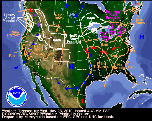
The heaviest snowfall in the nation on Thursday will be around the Great Lakes in Michigan where up to 10 inches (25 cm) of snow was expected, and in parts of the U.S. West where a storm is pushing inland from the Pacific Coast, Burke said.
The Sierra Nevada mountain range in California and the mountains around Yellowstone National Park in Wyoming could receive more than two feet (61 cm) of snow, Burke said.
(Reporting by Alex Dobuzinskis in Los Angeles and Timothy Mclaughlin in Chicago; Editing by Will Dunham)


