Tropical Storm Hermine pounds into the Carolinas

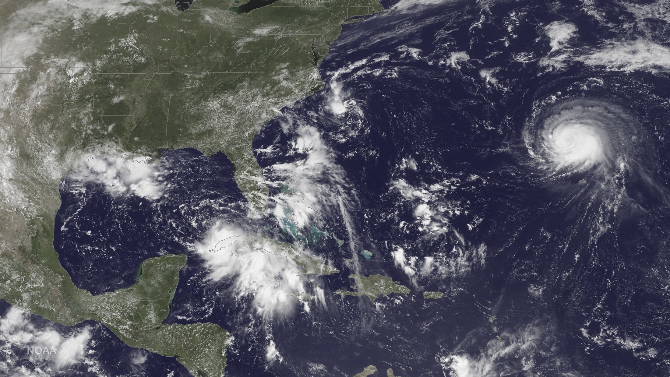
Three storm systems are shown (L TO R) Tropical Depression Nine to the southeast of Florida,

By Letitia Stein

TAMPA, Fla., Sept 2 (Reuters) – Hurricane Hermine wreaked havoc across Florida on Friday, causing widespread power outages and flooding before diminishing into a tropical storm and plowing up the Atlantic Coast into the Carolinas with a still-potent mix of high winds and heavy rains.

The first hurricane to make landfall in Florida in 11 years Hermine swept ashore early on Friday near the Gulf shore town of St. Marks, 20 miles (30 km) south of the capital of Tallahassee, packing winds of 80 mph (130 kph) and churning up a devastating storm surge in coastal areas.

Torrential downpours and high surf left parts of some communities under water early Friday, with mandatory evacuations ordered in parts of five northwestern Florida counties.

State officials said electricity had been knocked out to nearly 300,000 homes and businesses by afternoon.

One storm-related death was reported by authorities in the northern Florida town of Ocala, where a fallen tree killed a homeless man sleeping in his tent.

Hermine was expected to snarl Labor Day holiday travel as it churned northeast for several more days after battering Florida’s $89 billion tourism industry.

While maximum sustained winds had weakened to 50 mph (80 kph), the tempest headed to the Atlantic seaboard along a path inhabited by tens of millions of Americans, prompting storm
watches and warnings as far north as Rhode Island.

As of 9 p.m. EDT (0100 GMT), the fourth named storm of the 2016 Atlantic hurricane season was passing near Myrtle Beach, South Carolina, leaving some 51,000 power outages across the state, said state emergency management spokesman Derrec Becker.

Becker said localized flooding hit low-lying areas across the state, and there were widespread reports of “downed power lines, downed trees, trees on cars and some flooded cars,” along with isolated incidents of tree-damaged homes.

One mobile home was virtually sliced in two by a fallen tree, but authorities had no reports of serious storm-related injuries or fatalities, Becker added.

Likewise, emergency officials reported no storm deaths in Georgia, which Hermine swept through on its way to South Carolina, but said at least 100,000 utility customers were
without power at one point.

Emergency declarations remained in effect for all or parts of Florida, Georgia, North Carolina, Virginia and Maryland.

LIKELY TO REGAIN STRENGTH

The storm was projected to creep north along the Carolina coast Friday night, then gather strength after moving offshore into the Atlantic on Saturday morning, possibly reaching near-hurricane intensity by late Sunday, according to the National Hurricane Center.

In addition to powerful winds extending up to 185 miles (295 km) from its center, Hermine was expected to unleash a dangerous storm surge in the Hampton Roads area of tidewater Virginia, where flooding could become 3 to 5 feet deep, the NHC warned.

The storm also could douse several southeastern and mid-Atlantic states with up to 15 inches (38 cm) of rain through Sunday, the agency said.

New Jersey, still mindful of devastation from superstorm Sandy in 2012, was on high alert as emergency officials advised residents to prepare for flooding, high winds and a surge of
seawater.

New York Governor Andrew Cuomo on Friday activated his state’s emergency operations center and ordered officials to stockpile resources, including sandbags and generators.

New York City Mayor Bill De Blasio said residents should avoid beach waters for fear of life-threatening riptides. “I say that to people who go the beach, I say that to surfers: Don’t even think about it,” De Blasio told reporters.

In Florida, concerns over the standing water in which mosquitoes breed intensified as the state battled an outbreak of the Zika virus.

“It is incredibly important that everyone does their part to combat the Zika virus by dumping standing water, no matter how small,” Florida Governor Rick Scott told a news conference.

Overnight, crews in Pasco County, Florida, rescued more than a dozen people after their homes were flooded.

Richard Jewett, 68, was rescued from his home in New PortRichey, just north of Tampa, as emergency teams carried out amandatory evacuation.

“The canal started creeping up toward the house, and even though it wasn’t high tide it looked like it was coming inside,” Jewett said.

(Additional reporting by Zachary Fagenson in Hudson Beach,
Fla., Steve Gorman in Los Angeles, Brendan O’Brien in Milwaukee,
Laila Kearney in New York and Jon Herskovitz in Austin; Editing
by Daniel Trotta and Cynthia Osterman)

Hermine tears through Florida, raises new Zika fears

Robert Long and his son J.D. watch workers removing downed trees during cleanup operations in the aftermath of Hurricane Hermine in Tallahassee

By Letitia Stein

TAMPA, Fla. (Reuters) – Hurricane Hermine tore a path of destruction across Florida on Friday, knocking out power for 253,000 customers, flooding low-lying areas and raising concerns about the spread of the Zika virus from pools of standing water left behind.

The first hurricane to make landfall in Florida in more than a decade, Hermine came ashore early on Friday near St. Marks, Florida, 20 miles (30 km) south of the capital of Tallahassee, packing winds of 80 mph (130 kph) and churning up a devastating storm surge in coastal areas.

Hermine, which has since been downgraded to a tropical storm, was set to snarl U.S. Labor Day holiday travel as it moves northeast after battering Florida’s $89 billion tourism industry.

The storm center was on the border between Georgia and South Carolina at 2 p.m.(1800 GMT), the National Hurricane Center (NHC) said.

A huge pine tree is shown after falling through a home from the wind and rain damage of Hurricane Hermine in Tallahassee, Florida

A huge pine tree is shown after falling through a home from the wind and rain damage of Hurricane Hermine in Tallahassee, Florida September 2, 2016. REUTERS/Phil Sears REUTERS/Phil Sears


Though sustained winds had weakened to 50 mph (80 kph), the tempest headed toward the Atlantic seaboard on a path where tens of millions of Americans live, causing storm watches and warnings stretching to Rhode Island, NHC said.

It could strengthen again over water and possibly bring up to 15 inches (38 cm) of rain to the southeastern and mid-Atlantic states over the next 48 hours, with heavy rainfall possibly hitting coastal Delaware and New Jersey starting on Saturday night, the center said.

New Jersey, still mindful of the devastation caused by Hurricane Sandy in 2012, was on high alert as emergency officials advised people to prepare for flooding, high winds and a surge of seawater.

New York Governor Andrew Cuomo on Friday activated his state’s emergency operations center and advised emergency officials to stockpile resources, including sandbags and generators.

As it tracks north offshore towards New York, the storm is projected to stall at sea through Wednesday morning, the National Hurricane Center said.

New York Mayor Bill De Blasio said residents should avoid beach waters for fear of life-threatening riptides caused by the lingering storm. “I say that to people who go the beach, I say that to surfers: Don’t even think about it,” De Blasio told a news conference.

WORRIES ABOUT ZIKA

In Florida, concerns over the standing water in which mosquitoes breed intensified as the state battles an outbreak of the Zika virus.

“It is incredibly important that everyone does their part to combat the Zika virus by dumping standing water, no matter how small,” Florida Governor Rick Scott told a news conference, also warning people to look for downed power lines and avoid driving in standing water pools.

There have been 47 cases of Zika in people believed to have contracted the virus through local mosquitoes, according to the Florida Department of Health. Active transmission is thought to be occurring in two small areas around Miami.

As the sun rose on Friday morning on Hudson Beach, just north of Tampa, cars sat askew in flooded roads. Palm fronds, tree branches and garbage cans were scattered about.

Overnight, Pasco County crews rescued more than a dozen people after their homes were flooded.

Richard Jewett, 68, was rescued from his home in New Port Richey, just north of Tampa, around 1:30 a.m. EDT (0530 GMT) as emergency workers carried out a mandatory evacuation.

“The canal started creeping up toward the house and even though it wasn’t high tide it looked like it was coming inside,” Jewett said.

In Cedar Key, an island community in northwest Florida, waters rose more than 9.5 feet (2.9 meters), among the highest surges ever seen, the National Weather Service said.

“This is one of the worst that we have seen in the city in a long time, and unfortunately, it is not over yet,” St. Petersburg, Florida, Mayor Rick Kriseman told reporters.

(Additional reporting by Zachary Fagenson in Hudson Beach, Fla., Brendan O’Brien in Milwaukee, Laila Kearney in New York and Jon Herskovitz in Austin; Editing by Daniel Trotta and Cynthia Osterman)

Hurricane warning issued for parts of Florida; Madeline weakens

A city worker fills sandbags to help residents prepare for an expected tropical storm in Gulfport, Florida

TAMPA BAY, Fla. (Reuters) – Forecasters and public officials urged Floridians to prepare for potentially catastrophic flooding and damaging winds as Tropical Storm Hermine was expected to become a hurricane by the time it reached Florida’s northern Gulf Coast on Thursday.

A hurricane warning was in effect for the Florida panhandle from the Suwannee River to Mexico Beach as the strengthening storm was expected to sweep across northern parts of the state and then northeast along the Atlantic Coast, the National Hurricane Center said in an advisory.

The forecast of rough weather prompted Florida Governor Rick Scott to declare an emergency on Wednesday as many school districts along the Gulf Coast canceled after-school activities and ordered students to stay home on Thursday.

Cities such as Tallahassee and Orlando were offering sandbags to residents to protect homes and businesses from flooding caused by the up to 10 inches (25 cm) of rain as heavy rains were already pounding parts of the state and were expected through Friday.

“There is a danger of life-threatening inundation,” said the center’s advisory that noted the possibility of as much as 20 inches (20 cm) of rain to fall in some isolated areas and life-threatening flash flooding.

The storm, packing winds of 60 mph (95 kmh) with higher gusts, was expected to get stronger by the time it reach landfall, making outside preparations difficult or dangerous, the center said.

“Heavy rainfall and strong winds will make driving dangerous. Even after the storm passes, citizens should avoid unnecessary travel to allow first responders and road clearing crews to quickly respond to emergency needs,” the City of Tallahassee said in an alert to residents.

Three storm systems are shown (L TO R) Tropical Depression Nine to the southeast of Florida, Tropical Depression Eight just off the coast of the Carolinas and Hurricane Gaston in the central Atlantic Ocean are shown in this GOES East satellite image captured August 29, 2016. NOAA/handout via REUTERS

Three storm systems are shown (L TO R) Tropical Depression Nine to the southeast of Florida, Tropical Depression Eight just off the coast of the Carolinas and Hurricane Gaston in the central Atlantic Ocean are shown in this GOES East satellite image captured August 29, 2016. NOAA/handout via REUTERS

On its current path, the system would also dump as much as 10 inches (25 cm) of rain on coastal areas of Georgia, which was under a tropical storm watch, and the Carolinas.

A tropical storm warning was also issued for the U.S. east coast from Marineland, Florida to South Santee River, South Carolina, the Miami-based weather forecaster said.

U.S. oil and gas producers in the east of the Gulf of Mexico removed workers from 10 offshore platforms, moved drilling rigs and shut some output because of the storm.

The hurricane center also said in an advisory that the center of Hurricane Gaston will move near the Azores on Friday.

Meantime, Hurricane Madeline weakened to a tropical storm as it passed south of Hawaii’s Big Island, where officials opened shelters and closed offices, schools and roads on Wednesday.

The tropical storm, before it moves westward out of reach of Hawaii, was expected to dump as much as 15 inches (40 cm) of rain on parts of the Big Island, according to the National Weather Service.

Hurricane Lester, currently a major Category 4 storm, could affect Hawaii over the weekend.

Hawaii Governor David Ige signed an emergency proclamation that runs through Sept. 9, freeing up state resources.

(Reporting by Brendan O’Brien in Milwaukee; Editing by Toby Chopra)

Storm bears down on Florida, hurricane threatens Hawaii

Three storm systems are shown (L TO R) Tropical Depression Nine to the southeast of Florida, Tropical Depression Eight just off the coast of the Carolinas and Hurricane Gaston in the central Atlantic Ocean are shown in this GOES East satellite image captured August 29, 2016.

(Reuters) – Forecasters issued a tropical storm warning on Wednesday for the Florida Gulf Coast, where preparations were being made for life-threatening flooding and fierce winds, while residents of Hawaii’s Big Island were warned of an encroaching hurricane.

Some local governments in Florida have begun distributing sandbags as the unnamed tropical depression heads toward the state’s Gulf Coast where as much as 15 inches of rain could fall from Indian Pass on the panhandle along the Gulf of Mexico to north of Tampa, the National Hurricane Center said in an early morning advisory.

“Persons located within these areas should be prepared to take all necessary actions to protect life and property from rising water,” the center said.

The center also issued a hurricane watch for the coast, saying the system, which is currently packing 35 mph (55 kph) with higher gusts, is expected to strengthen as it heads east.

Flooding, storm surge, fierce winds and tornadoes were all threats to the region, which could begin feeling the storm late on Wednesday, Florida Governor Rick Scott said in a statement.

On its current path, the system could make landfall on Florida’s north-central Gulf Coast on Thursday, bringing storms into Georgia and the eastern Carolinas on its way to the Atlantic Ocean.

Florida raised the activation status of its State Emergency Operations Center on Tuesday to begin preparing.

Another unnamed tropical depression was turning out to sea on Wednesday after threatening the North Carolina coast, according to the hurricane center.

On Hawaii’s Big Island, residents were warned on Tuesday of an encroaching hurricane expected to bring strong winds and heavy rains.

The National Weather Service (NWS) tracked Hurricane Madeline swirling about 235 miles (380 km) east of the town of Hilo around 11 p.m. local time on Tuesday. The storm was forecast to “pass dangerously close” on Wednesday, prompting the NWS to issue a hurricane warning for the island.

Madeline was ranked as a Category 1 hurricane with maximum sustained winds of 90 mph (150 kph), the weather service said.

The County of Hawaii sent residents an alert about the hurricane’s dangers, including heavy rains that could lead to mudslides, as well as possibly damaging ocean swells.

“Preparations to protect life and property should be completed by nightfall today,” the alert said.

(Reporting by Brendan O’Brien in Milwaukee; Editing by Richard

Louisiana assesses flood damage as residents return to soaked homes

Flooding in Louisiana clean up

By Sam Karlin

GONZALES, La. (Reuters) – Ron Allen set out electric fans at his rental property in southeastern Louisiana on Wednesday, hoping to dry floors that had been swamped by nearly a foot of water.

“We’ve got to pull out the wood, pull out the vinyl. But first we gotta get the water out,” said Allen, 66. “This has never happened before.”

Record floods have been blamed for at least 13 deaths and damage to about 40,000 homes. Authorities have only begun assessing the devastation.

Rains that started last Thursday have dumped more than 2-1/2 feet (0.76 meters) of water on parts of Louisiana.

The American Red Cross has called the flooding the worst disaster in the United States since Super Storm Sandy hit the U.S. East Coast in 2012.

“Thousands of people in Louisiana have lost everything they own and need our help now,” Brad Kieserman, vice president of disaster services operations and logistics for the Red Cross, said in a statement.

As of Wednesday afternoon, shelters across the state were housing 5,435 people, according to the Louisiana Department of Children and Family Services.

U.S. President Barack Obama signed a Louisiana disaster declaration on Sunday and ordered federal aid to supplement state and local efforts.

The White House said on Wednesday that Obama had directed the Federal Emergency Management Agency to “utilize all resources available” in responding to the flooding.

Swollen creeks and bayous were still overflowing on Wednesday in downstream communities such as Gonzales, as recovery efforts were beginning around Baton Rouge.

In Livingston Parish, east of Baton Rouge, at least 75 percent of homes were flooded, the sheriff’s office said on Facebook. The parish includes Denham Springs, where about 90 percent of the homes and every local school took in water, Mayor Gerard Landry told local radio station Talk 107.3.

Landry said he thought it could take two to three months to reopen schools.

“These folks that have flooded, they don’t have shoes. They don’t have underwear. They don’t have shirts. They don’t have toilet paper,” he said in the radio interview on Wednesday. “All the basic essential needs, they don’t have.”

For Terry Lyon, 56, the devastation was all too familiar. His trailer was destroyed 11 years ago in Hurricane Katrina, which struck the U.S Gulf Coast and left more than 1,800 people dead.

Lyon’s apartment in Baton Rouge flooded on Saturday, and he and his wife drove to stay with relatives on dry ground in Ascension Parish. By Monday evening, many there were underwater.

“I’ve never seen water come up like this and come after us,” said Lyon, standing outside a shelter in Gonzales, Louisiana. “I never dreamed it could get this bad.”

(Reporting by Sam Karlin; Additional reporting by Bryn Stole in Baton Rouge, La.; Writing by Letitia Stein; Editing by Tom Brown, Toni Reinhold)

Eleven dead, thousands of homes ravaged in Louisiana floods

Residents use a boat to navigate through the floods in Louisiana

By Sam Karlin

BATON ROUGE, La. (Reuters) – Search-and-rescue operations were still underway on Tuesday in Louisiana, where at least 11 people have died in severe floods that damaged about 40,000 homes, state officials said.

Emergency crews had already plucked more than 20,000 people and 1,000 pets from flooded areas after a storm that broke records for 24-hour rainfall in multiple locations, Governor John Bel Edwards told reporters.

Rain-swollen rivers are receding in much of the state, but state officials warned of remaining dangers. Some communities in southern Louisiana could see waters crest later in the week, according to national forecasters.

More than 8,000 people slept in emergency shelters on Monday night, unable to return to their homes, Edwards told a news conference. The state planned to impose curfews on Tuesday night in the parishes with widespread damage.

“This is a historic flooding event,” Edwards said. “It’s unprecedented.”

The storm dumped more than 2-1/2 feet (76 cm) of rain near Watson, Louisiana, from Thursday to Monday morning, the highest total reported, according to the National Weather Service.

In Abbeville, Louisiana, a 125-year-old record for 24-hour rainfall was shattered with 16.38 inches (41.61 cm) reported from Friday to Saturday, the weather service reported.

In some water-ravaged areas, houses flooded to rooflines, and coffins floated away. Motorists were trapped on highways. U.S. President Barack Obama issued a disaster declaration on Sunday, with a total of 20 parishes approved by Tuesday for federal assistance.

Already, 40,000 residents have registered for disaster aid, Edwards said.

In hard-hit Denham Springs, residents were gutting waterlogged homes, dumping soaked carpets and mattresses.

Sonya Mayeux was still in disbelief. On Saturday, she awoke at 9 a.m. to rising, knee-deep water in her backyard. By 11:30 a.m., the water was nearly above her white SUV.

A neighbor rescued her family by boat. Ultimately, her house flooded nearly to the roof.

“The water just came up so fast,” she said.

“VERY LARGE DISASTER”

Craig Fugate, head of the Federal Emergency Management Agency, told reporters the “very large disaster” was affecting more people than flooding in March that left at least four dead and thousands of homes damaged in Louisiana and Mississippi.

Louisiana will mark the 11th anniversary this month of Hurricane Katrina, which killed more than 1,800 people when floods overwhelmed levees and broke through flood walls protecting New Orleans on Aug. 29, 2005.

Louisiana’s confirmed death toll from the latest flooding rose to 11 on Tuesday, the state Health Department said. By parish, it reported five fatalities in East Baton Rouge, three in Tangipahoa, two in St. Helena, and one in Rapides.

Among those killed was Bill Borne, the founder and former chief executive of Amedisys Inc, a provider of home health and hospice care. Officials said he drowned near his home in East Baton Rouge Parish.

(Additional reporting by Ian Simpson in Washington, Colleen Jenkins in Winston-Salem, North Carolina, and Bryn Stole in Baton Rouge, Louisiana; Writing by Letitia Stein in Tampa, Florida; Editing by Tom Brown)

Flooding disaster that killed seven in Louisiana now menaces Texas

Richard Rossi and his 4 year old great grandson Justice wade through water in search of higher ground after their home took in water in St. Amant, Louisiana,

By Bryn Stole

LIVINGSTON, La. (Reuters) – Overwhelmed rivers in much of southern Louisiana receded slowly from record levels on Monday while crews in boats searched for more people stranded in inundated homes after three days of torrential rains that killed seven people.

While the threat of flash flooding moved west into Texas, more than 11,000 Louisianans have signed up for disaster assistance. Many are waiting for the flood waters to drain away so they can determine what can be salvaged from their sodden homes and businesses.

Emergency crews already have rescued more than 20,000 people and continued to search for more after a storm dumped more than 2 feet (61 cm) of rain in three days.

Aerial photographs on Sunday showed houses inundated in mud-colored water with only their roofs visible while the bridge over the Amite River around Port Vincent, Louisiana, was almost underwater. People had become trapped overnight in their cars when the water rose on Saturday over parts of a major interstate around Baton Rouge.

While some rivers were receding on Monday, others downstream were still cresting.

“The water started rising three or four days ago and it’s still coming up right now,” said Lonnie Wells, 59, as he stood on flooded state highway in French Settlement, a town in southern Livingston Parish.

Wells said he would try to ride out the floods with his chickens, rabbits, goats and dogs, although neighbors urged him to flag down a passing Louisiana National Guard truck to get out.

The Louisiana flooding, which prompted U.S. President Barack Obama to issue a disaster declaration, resulted in seven deaths, National Weather Service meteorologist Jennifer McNatt said. Four occurred when people drove vehicles into high waters.

“IT’S GOING TO TAKE A WHILE”

The flood waters were expected to linger.

“It is going to take a while for that water to make its way out,” McNatt, who is based in Fort Worth, Texas, said in a telephone interview.

Rivers in Louisiana crested at record levels in multiple places, with the Amite River reaching 46.2 feet (14 meters) in Denham Springs, 5 feet (1.5 meters) higher than a 1983 record, McNatt said.

In flood-ravaged Livingston Parish, scores of people woke up on Monday in packed emergency shelters, sprawled out wherever they could find room. Emergency rescuers worked through the night to bring to safety people who were still stranded in roads in the middle of subdivisions, surrounded by flood water.

Pierre and Barbara Pitard, both 76, had just minutes to leave their home in Denham Springs as the water rose rapidly. The couple fled first to a neighbor’s two-story house before moving on to a Walmart, a gas station and a community center. They were finally rescued by boat and carried to safety on Saturday night, the vessel rocking as it hit submerged pickup trucks on streets inundated by water.

Pierre Pitard accepted the damage to his home but fretted about the scope of the state’s devastation.

“It’s already under water,” he said of his house. “I’m worried about how you go about getting it fixed because you’ve got thousands of people now with the exact same problems.”

Some 11,000 people already have registered with the federal government’s disaster assistance website, Louisiana Governor John Bel Edwards said in a Twitter post on Monday morning.

Flooding in Texas was a concern on Monday with the NWS saying a flood watch extended from Houston to the Hill Country region in the central part of the state. Rain also could menace parts of Arkansas in the next two days, McNatt said.

(Writing by Letitia Stein; Editing by Bill Trott)

Motiva refinery in Louisiana surrounded by high water from flooding

Smoke is seen rising from the Motiva Enterprises refinery after a fire broke out in Convent, Louisiana

HOUSTON (Reuters) – The fire-damaged hydrocracking unit at Motiva Enterprises’  235,000 barrel per day Convent, Louisiana, refinery was surrounded by high water on Friday from heavy rains overnight, sources familiar with plant operations said.

The other units at the refinery were not in danger of flooding from heavy rains that were continuing to fall in south Louisiana on Friday, the sources said.

The structure of the 45,000 bpd heavy oil hydrocracker, called the H-Oil unit, was heavily damaged in a blaze on Thursday and efforts to limit environmental damage from fighting the fire are contributing to the flooding around the HCU.

Rubber blocks were that were placed in storm drains on Thursday to prevent hydrocarbons from getting into the storm water system have become stuck, preventing drainage of the high water, the sources said.

The National Weather Service has issued a flash flood warning for south Louisiana on Friday, saying heavy rains since Wednesday have saturated the ground.

An initial assessment on Thursday of damage to the H-Oil unit’s structure was that repairs could take between one and four months, but a more detailed inspection and damage assessment cannot be conducted until the HCU cools down from the fire, said the sources, who were not authorized to speak publicly about the matter.

The detailed inspection could narrow or expand the time needed for repairs. The H-Oil unit’s reactors, where hydrogen is mixed with gas oil in motor fuel production, appeared to have little damage from the blaze in the initial assessment.

No injuries were reported from the blaze that lasted about four hours and all other units at the refinery remained in operation, Motiva said on Thursday.

Hydrocrackers use hydrogen under high pressure to produce motor fuels from gas oil produced by crude distillation units.

(Reporting by Erwin Seba; Editing by Chizu Nomiyama and Matthew Lewis)

Macedonia declares emergency after 21 die in flash floods

A wrecked car is seen after heavy floods in Cento

By Kole Casule

SKOPJE (Reuters) – Macedonia declared a state of emergency in its capital Skopje and neighboring districts on Sunday, a day after at least 21 people were killed in flash floods caused by a storm.

Torrential rains flooded homes, swept away a section of the ring road around Skopje and wrecked cars late on Saturday evening. Northern suburbs of the capital were particularly hard hit, though the city center also suffered flash floods.

Children were among those killed, a police spokesman said, adding that searches were continuing for six people who have been reported missing.

Macedonia, a small former Yugoslav republic of about two million people, has declared Monday a day of national mourning.

“This is a catastrophe of unprecedented magnitude,” Deputy Prime Minister Nikola Todorov told reporters.

Special police forces and trucks loaded with drinking water were sent to the worst affected areas, where there also have been some electricity outages and where scattered debris of furniture swept away from houses could be seen on the streets, a Reuters reporter said.

The rain had stopped by Sunday morning and water levels were receding, though there was some more rain on Sunday evening in Skopje. There were no reports of further flash flooding.

European Union Enlargement Commissioner Johannes Hahn said on Twitter that the EU stood ready to help Macedonia, which is a candidate to join the bloc.

Further north in the Balkans, in Croatia, heavy winds caused disruptions on some roads, including the closure of the highway linking the capital Zagreb to southern coast for lorries and buses, local media said.

(Additional reporting by Igor Ilic in Zagreb; Writing by Ingrid Melander; Editing by Gareth Jones)

Natural disasters in China kill more than 800 since June

Flooding in China one of the many natural disasters

BEIJING (Reuters) – More than 800 people have died and about 200 are missing in a series of natural disasters that have struck China since June, the worst casualty figures since a similar period in 2011, state media said on Tuesday.

Large parts of central, eastern and northern China have been hit by flooding this summer, while a typhoon left a wave of destruction this month and a freak tornado killed at least 98 in the eastern province of Jiangsu in June.

Since the year began, 1,074 people have died in natural disasters, 833 of them since June, with 270 missing, Xinhua news agency cited the Ministry of Civil Affairs as saying.

Direct economic losses have reached 298 billion yuan ($44.63 billion) this year, with about 400,000 houses destroyed and 6.24 million residents relocated, the ministry added.

Separately, the government on the southern island province of Hainan issued a typhoon warning for a tropical storm that is expected to hit in the early hours of Wednesday.

($1=6.6769 Chinese yuan renminbi)

(Reporting by Ben Blanchard; Editing by Clarence Fernandez)