Floods kill 120 in India’s Gujarat, with industry, cotton hit

People use boats as they try to move to safer places along a flooded street in West Midnapore district, in West Bengal. REUTERS/Rupak De Chowdhuri

By Amit Dave

AHMEDABAD, India (Reuters) – Widespread flooding in India’s western industrial state of Gujarat has killed more than 120 people and paralyzed infrastructure, officials said on Friday, with tens of thousands of cotton farmers also suffering heavy damage.

Torrential monsoon rain and flooding in recent weeks have killed at least 300 people in western and eastern states, an official in the National Disaster Management Authority told Reuters in New Delhi.

“Our teams are working in different parts of India with soldiers to ease the situation,” said Deepak Ghai, an emergency room control officer.

More than a million households had been affected and losses to farmlands were being assessed.

The airport in Ahmedabad, the main commercial hub of Gujarat, was partially flooded, forcing airlines to divert flights. More than 150 factories were forced to shut down, said A.R. Raval, a district administrator.

The floods have come at a particularly bad time for cotton farmers in Gujarat, Prime Minister Narendra Modi’s home state.

Raval said more than 50,000 were struggling to drain water from their land and homes.

Recent downpours have hit cotton and millet in Gujarat and Rajasthan, where farm experts now fear pest infestations.

“Cotton and millet harvests are expected to suffer in about three districts each in Gujarat and Rajasthan, but the biggest worry is that the extra moisture could lead to pest attacks in these areas,” Devinder Sharma, an independent farm expert, said.

Rains have been 4 percent above average since the four-month monsoon season began in June, according to the state-run India Meteorological Department.

(Additional reporting by Mayank Bhardwaj Writing by Rupam Jain)

Massive wildfire destroys 29 structures in California

A firefighter walks near a home as flames from the fast-moving Detwiler fire approach in Mariposa, California U.S. July 19, 2017. REUTERS/Stephen Lam

(Reuters) – More than 3,000 firefighters on Thursday battled a raging wildfire in central California that has destroyed 29 structures and forced thousands to flee their homes as it threatened a picturesque gold rush town outside Yosemite National Park.

Just seven percent of the Detwiler Fire has been contained as it threatens the town of Mariposa and tiny communities in the foothills of the Sierra Nevada mountains, the Cal Fire state agency said on its website.

“Everybody’s heart is in the game,” Battalion Chief Jeremy Rahn told a community meeting on Wednesday night, noting that about 3,100 firefighters from across the region were battling the blaze, according to the Fresno Bee newspaper. “We are totally invested in this.”

The blaze has mushroomed to 48,000 acres (19,424 hectares), an increase of about 23,000 acres (9,307 hectares) compared to the day before. The fire has destroyed 29 structures and damaged five others as it threatens some 1,500 more structures, according to the California Department of Forestry and Fire Protection, or Cal Fire.

The small communities of Coulterville and Greeley Hill were ordered evacuated on Wednesday.

Mariposa’s 2,000 residents were told to leave town on Tuesday after its power and water links were damaged. In total, nearly 5,000 people are under orders to vacate their homes, officials said.

The town’s hospital, called the John C. Fremont Healthcare District, and its 14 patients did not evacuate, at the advice of fire officials, said the facility’s interim CEO Matthew Matthiessen.

The California blaze was among 37 active large fires spread across 12 western states as of Wednesday, according to the National Interagency Fire Center’s website.

Governor Jerry Brown declared a state of emergency for Mariposa County on Tuesday, dispatching resources to the area.

(Reporting by Brendan O’Brien in Milwaukee; Editing by Chizu Nomiyama)

Body of missing man believed found after deadly flash flood in Arizona

By David Schwartz

PHOENIX (Reuters) – The remains of a 27-year-old man were believed to have been recovered on Wednesday, four days after a flash flood rushed down a rain-swollen canyon in central Arizona killing his wife and eight other family members, a local sheriff said.

Authorities said the body of Hector Miguel Garnica was spotted by a state helicopter surveying the area on Wednesday afternoon during a search near Payson, Arizona, about 90 miles northeast of Phoenix.

“We have located remains that we believe to be involved in this tragic flooding incident,” said Gila County Sheriff Adam Shepherd, during a news conference at the search site.

Sheperd said family members have been notified and a formal confirmation is pending a DNA analysis by state officials.

The remains were recovered on the fifth day of an intense search launched on Saturday, when a group of family members were swept away by what authorities described as a wall of water that crashed down the canyon at a popular swimming spot in the Tonto National Forest.

The 14-member group was celebrating Garnica’s wife’s birthday, authorities said.

Five children and five adults were killed in the incident ranging from two to 57 years old, sheriff’s officials said. Four family members were rescued.

Authorities said the group was engulfed by a sudden flash flood when a thunderstorm dumped as much as 1.5 inches (3.8 cm) of rain in 20 to 30 minutes about 8 miles (13 km) away from an area that had been burned by a nearly 7,200-acre (2,914 hectares) wildfire last month.

A video posted on social media showed the muddy, debris-filled torrent rushing down a canyon on Ellison Creek where the family was taking in the cool waters at a swimming spot frequented by dozens that day.

Some 130 searchers from 24 agencies took part in the search at its peak, including divers and cadaver dogs, authorities said.

(Reporting by David Schwartz in Phoenix; Editing by Christian Schmollinger)

Windy, dry weather forecast in U.S. West, threatens to stoke wildfires

A USFS bulldozer cuts a line through vegetation to create a safety line below West Camino Cielo while fighting the Whittier Fire near Santa Barbara, California, U.S. July 15, 2017. Mike Eliason/Santa Barbara County Fire Department/Handout via REUTERS

(Reuters) – More than 800,000 residents in the U.S. West were told to be ready to evacuate on Tuesday as windy, dry conditions threatened to stoke wildfires, forecasters said.

A red flag warning was issued for southern Oregon, northern California and northern Nevada as 35 mph (55 kph) wind gusts and humidity hovering around 10 percent were seen, the National Weather Service said in an advisory.

“Strong winds could rapidly push fire into close proximity of local communities Tuesday afternoon and evening. Heed any evacuation orders. React quickly, you may not have much time to leave,” the service said.

More than a half a dozen fires have started up over the last two days in California including the Detwiler Fire, which forced some residents in Mariposa County to evacuate on Monday.

The fire destroyed one structure and threatened 300 more after swelling to 11,200 acres since it began burning brush and tall grass on Sunday afternoon. Five percent of the fire was contained as of Monday night, the Cal Fire website reported.

“I haven’t seen these conditions in a long time, it’s a wind driven, slope driven, fuel-driven fire,” Jerry Fernandez with Cal Fire told an ABC affiliate in Fresno.

Ten new large blazes ignited on Monday as a total of 35 wildfires burned across the U.S. West, the National Interagency Coordination Center said.

Flames have charred more than twice as much land in California so far in 2017 compared with the same time last year, according to Cal Fire.

(This story has been refiled to delete extraneous word in headline.)

(Reporting by Brendan O’Brien in Milwaukee; Editing by Richard Balmforth)

Tropical Depression Cindy still packs a punch after landfall on Thursday

Radar from the continued threat of Tropical Storm Cindy

By Kami Klein

In the wake of the landing of Tropical Depression Cindy, there is extensive flooding in many states, the death of a 10 year old boy from debris in Fort Morgan, Alabama  as well as the damage and injuries from an F2 tornado that plowed through Birmingham, Alabama on Thursday,  From reports by the National Weather Service, this was just the beginning of problems that will be arising from this intense storm system.   

The F2 Tornado that hit a heavily populated area in Birmingham, Alabama Thursday afternoon left extensive structural  damage and injured four people. The Weather Channel also reported that Mayor Tim Kerner of the town of Lafitte, Louisiana (located south of New Orleans) said the rising water may impact homes and vehicles, and he issued a voluntary evacuation for all residents.

The AP has reported that more than a foot of rain has fallen in Ocean Springs, Mississippi. Residents are concerned with the damages and hazards brought by the immense amount of water, including the dangers of alligators that are prevalent in many ponds and will now move into more populated areas.  

Mississippi residents are not the only people concerned about frightening impacts in nature caused by the flooding. The Alabama Cooperative Extension System warned of floating colonies of fire ants in the flood waters.  In a statement, the agency said the fire ants may resemble ribbons, streamers or large balls of ants floating on the water and that residents should be on the lookout when maneuvering in or being near flooded areas.

So far the states of Louisiana, Mississippi, Alabama, Texas, Tennessee and even southern Arkansas have been affected by the torrential rains contained in Tropical Depression Cindy.  Officials in all states have warned that there is a strong possibility for more flash flooding and tornadoes.  

In a report by The Weather Channel, remnants of the storm moved into Tennessee on Friday, knocking down trees and prompting power outages. According to Memphis Light Gas and Water, nearly 10,000 customers were without power Friday morning. Kentucky and West Virginia are bracing themselves for Heavy rainfall and flooding and reports from the weather service show that portions of Michigan and Indiana are also being affected by this storm system as well.  

The National Weather Service says that the path of Tropical Storm Cindy will spread heavy rain into the Tennessee and Ohio Valleys today – and into the Appalachians and Mid-Atlantic tonight. Flash flooding is possible in these areas as well as strong to severe thunderstorms.  


U.S. Gulf Coast braces for Tropical Storm Cindy

This graphic shows an approximate representation of coastal areas under a hurricane warning (red), hurricane watch (pink), tropical storm warning (blue) and tropical storm watch (yellow). The orange circle indicates the current position of the center of the tropical cyclone. The black line, when selected, and dots show the National Hurricane Center (NHC) forecast track of the center at the times indicated. The dot indicating the forecast center location will be black if the cyclone is forecast to be tropical and will be white with a black outline if the cyclone is forecast to be extratropical. Courtesy of NOAA and the National Weather Service

By Liz Hampton

(Reuters) – Communities and oil refining and production facilities from Texas to Florida braced on Tuesday for potential disruptions as Tropical Storm Cindy strengthened over the U.S. Gulf of Mexico, threatening to bring flash floods across parts of the northern Gulf Coast.

Cindy was located about 230 miles (365 km) south of Morgan City, Louisiana late Tuesday with maximum sustained winds of 60 miles (95 km) per hour, the National Hurricane Center said.

The storm was moving toward the northwest near seven miles (11 km) per hour, and this motion was expected to continue through Wednesday.

On the forecast track, the center of Cindy will approach the coast of southwest Louisiana and southeast Texas late Wednesday, and move inland over southeastern Texas on Thursday, the Miami-based weather forecaster said.

A Tropical Storm Warning is in effect for San Luis Pass, Texas to the Alabama-Florida border, Metropolitan New Orleans and Lake Pontchartrain.

“The winds aren’t looking to get much stronger than they are now,” but some areas east of Houston and toward Florida could see as much as 12 inches of rain, said Stephen Strum, vice president of extended forecast services at Weather Decision Technologies in Tulsa, Oklahoma.

“It’s moving fairly slow, so it’s going to produce rain for a long time,” he added.

Heavy rains and wind could disrupt oil supplies at the massive refining and production centers along the U.S. Gulf Coast, which could drive up prices for consumers. The Louisiana Offshore Oil Port (LOOP), the largest privately owned crude storage terminal in the United States, suspended vessel offloading operations ahead of the storm, but said it expected no interruptions to deliveries from its hub in Clovelly, Louisiana.

Royal Dutch Shell said it suspended some offshore well operations but production was so far unaffected. Anadarko Petroleum said it had evacuated non-essential staff from its Gulf of Mexico facilities.

Exxon Mobil Corp, Phillips 66, and Motiva Enterprises said the storm had not affected their refining operations.

Cindy was expected to produce six to nine inches (15-23 cm) of rain with isolated maximum amounts of 12 inches over southeastern Louisiana, southern Mississippi, southern Alabama, and the Florida Panhandle through Thursday, the NHC said.

Alabama Governor Kay Ivey declared a state of emergency. Officials in Houston, New Orleans and other cities along the Gulf Coast said they were monitoring developments. Florida Governor Rick Scott warned residents in the northwest part of his state to stay alert for flooding and heavy rain.

The storm could cause a surge of one to three feet along the coast and possibly spawn tornados from southern Louisiana to the Florida Panhandle, the NHC said.

The Gulf of Mexico is home to about 17 percent of U.S. crude output and 5 percent of dry natural gas output, according to the U.S. Energy Information Administration. More than 45 percent of the nation’s refining capacity is along the U.S. Gulf Coast, also home to 51 percent of total U.S. natural gas processing capability.

Crude oil prices for physical delivery along the U.S. Gulf Coast were relatively stable, but cash gasoline prices rose as traders expected heavy rains and possible flooding to hit refineries in the region.

Prompt U.S. Gulf Coast conventional gasoline firmed to trade as little as 2 cents per gallon under the RBOB futures contract, its strongest in four months.

WeatherBell Analytics LLC forecast 11 to 13 named tropical storms in the 2017 Atlantic Hurricane Season, according to a May outlook.

The Atlantic hurricane season runs from June 1 through Nov. 30, and has an annual average of 9.6 named storms, 5.9 hurricanes and 2.3 intense hurricanes.

Southeast of the Gulf of Mexico, a second tropical storm, Bret has been downgraded into a tropical wave.

(Reporting by Koustav Samanta, Nallur Sethuraman, Swati Verma, Apeksha Nair and Arpan Varghese in Bengaluru, Catherine Ngai and Devika Krishna Kumar in New York and Liz Hampton in Houston; Editing by Lisa Von Ahn, Chris Reese and David Gregorio)

Portugal’s deadliest fire still rages after 62 people killed

By Axel Bugge

PEDROGAO GRANDE, Portugal (Reuters) – More than 1,000 firefighters were still battling Portugal’s deadliest forest blaze on Monday after it killed at least 62 people over the weekend.

Prime Minister Antonio Costa, who on Sunday visited Pedrogao Grande, a mountainous area about 200 kilometers (125 miles) northeast of Lisbon, called it the biggest human tragedy in Portugal in living memory.

Welcome light rain that started on Monday morning brought only modest relief to the shocked population and exhausted firefighters. Water planes, including French and Spanish ones, resumed their missions after stopping overnight.

“There is still a lot of forest that can burn and the rain does not make much difference,” said Rui Barreto, deputy chief firefighter at the makeshift emergency services headquarters in Pedrogao Grande as thunder rolled through the skies over the ash-covered town.

Firefighters said the weather conditions were still adverse in most areas where the flames were raging. Two army battalions were helping the emergency services.

Dozens of fire engines drove back and forth to fight the raging blaze in areas as far as 20km north of Pedrogao Grande. In a sign of help Portugal is receiving from its European neighbors, four Spanish fire engines were seen driving off from the headquarters.

At least half the victims died in their cars as they tried to flee along a local motorway while many other bodies were found next to the road, suggesting they had probably abandoned their vehicles in panic.

Firefightes work to put out a forest fire near the village of Fato, central Portugal, June 18, 2017. REUTERS/Rafael Marchante

GOVERNMENT ASSURANCES

Despite government assurances that the first response by the emergency services was swift and adequate, many media and residents questioned the efficiency of the operation and the strategic planning in a country which is used to wooded areas burning every year.

“So what failed this Saturday? Everything, as it has failed for decades,” read a headline in the daily Publico, which blamed a lack of coordination between services in charge of fire prevention and firefighting and poor forestry reserve planning.

Police said a lightning strike on a tree probably caused the blaze on Saturday in a region hit by an intense heat wave and dry, gusty winds, which fanned the flames.

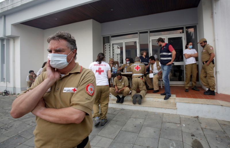
Red Cross and other relief personnel are seen outside a relief centre for people affected by a forest fire in Figueiro dos Vinhos, Portugal, June 19, 2017.

Red Cross and other relief personnel are seen outside a relief centre for people affected by a forest fire in Figueiro dos Vinhos, Portugal, June 19, 2017. REUTERS/Miguel Vidal

The regional prosecutor still ordered a criminal investigation into the causes, which he said would be shelved if the police version of events is confirmed. Many forest fires in Portugal are caused by arson or carelessness.

A public petition circulating on the Internet demanding an investigation into possible failures by the authorities has gathered about 270 signatures.

Local residents said they had been without the support of firefighters for hours as their homes burned. Many blamed depopulation of villages that left wooded areas untended.

(Story repeats fixing typo in second paragraph.)

(Writing by Andrei Khalip, editing by Ed Osmond)

Bangladesh raises highest danger warning as cyclone takes aim

A woman looks on inside her flooded house in Dodangoda village in Kalutara, Sri Lanka May 28, 2017. REUTERS/Dinuka Liyanawatte

By Ruma Paul and Dinuka Liyanawatte

DHAKA/AGALAWATTE, Sri Lanka/ (Reuters) – Bangladesh raised its storm danger signal to the highest level of 10 on Monday as a severe and intensifying cyclone churned toward its low-lying coast and was expected to make landfall in the early hours of Tuesday.

Impoverished Bangladesh, hit by cyclones every year, warned that some coastal areas were “likely to be inundated by a storm surge of four to five feet (1.2 to 1.5 meters)” above normal because of approaching Cyclone Mora.

The Disaster Ministry ordered authorities to evacuate people from the coast, the ministry’s additional secretary, Golam Mostafa, told reporters in Dhaka. About 10 million of Bangladesh’s population of 160 million live in coastal areas.

River ferries had suspended operations and fishing boats called in to safety.

“Maritime ports of Chittagong and Cox’s Bazar have been advised to lower danger signal number seven but instead hoist great danger signal number ten (repeat) ten,” a government weather bulletin said.

“The coastal districts of Chittagong, Cox’s Bazar, Noakhali, Laxmipur, Feni, Chandpur and their offshore islands … will come under danger signal number ten (repeat) ten.”

Bangladesh is hit by storms, many of them devastating, every year. Half a million people had their lives disrupted in coastal areas such as Barisal and Chittagong in May last year.

It is still recovering from flash floods that hit the northeast, affecting millions of people, in April. Rice prices have reached record highs and state reserves are at 10-year lows in the wake of flooding that wiped out around 700,000 tonnes of rice.

The cyclone formed after monsoon rains triggered floods and landslides in neighboring Sri Lanka, off India’s southern tip, which have killed at least 177 people in recent days, authorities said, with 24 killed in storms in the eastern Indian state of Bihar, either by lightning strikes or under collapsed village huts.

India warned of heavy rain in the northeastern states of Tripura, Mizoram, Manipur, Nagaland and Arunachal Pradesh as Mora moved further up the Bay of Bengal.

RUBBER AND TEA PLANTATIONS HIT

Floods reached roof level and cut off access to many rural Sri Lankan villages, disrupting life for 557,500 people, many of them workers on rubber plantations, officials said. Nearly 75,000 people had been forced out of their homes.

Villagers in Agalawatte, in a key rubber-growing area 74 km (46 miles) southeast of the capital, Colombo, said they were losing hope of water levels falling soon after the heaviest rain since 2003. Fifty-three villagers died and 58 were missing.

“All access to our village is cut off. A landslide took place inside the village and several houses are buried,” Mohomed Abdulla, 46, told Reuters.

Some areas in the southern coastal district of Galle, popular with foreign tourists, have not received relief due to lack of access.

“My entire village is cut off and nobody can come to this village,” C.M. Chandrapla, 54, told Reuters by phone from the tourist village of Neluwa.

“There have been no supplies for the past two days. Water has gone above three-storey buildings and people survive by running to higher ground.”

The Sri Lankan military has sent in helicopters and boats in rescue efforts in the most widespread disaster since the 2004 Boxing Day tsunami. About 100 people were missing in total.

The meteorology department forecast torrential rains over the next 36 hours.

Residents in seven densely populated districts in the south and center of Sri Lanka were asked to move away from unstable slopes in case of further landslides.

The wettest time of the year in Sri Lanka’s south is usually during the southern monsoon, from May to September. The island also receives heavy rains in the North West monsoonal season from November to February.

Reuters witnessed some people stranded on the upper floors of their homes. Civilians and relief officials in boats distributed food, water and other relief items.

One of the worst-hit areas was the southern coastal district of Matara which is home to black tea plantations. Rohan Pethiyagod, head of the Tea Board in the world’s largest exporter of top quality teas, said supplies would be disrupted for the next auction due to a lack of transportation.

Sri Lanka has already appealed for international assistance from the United Nations and neighboring countries.

(Additional reporting by Ranga Sirilal in Colombo; Writing by Shihar Aneez and Sanjeev Miglani; Editing by Nick Macfie)

U.S. weather forecasters predict above-normal hurricane season

A hurricane seen from space. Courtesy of Pixabay

By Laila Kearney

(Reuters) – U.S. weather forecasters on Thursday predicted more tropical storms in 2017 than normal for the Atlantic hurricane season, which last year brought one of the deadliest recorded storm systems that killed several hundred people.

Meteorologists with the National Oceanic and Atmospheric Administration’s Climate Prediction Center said there was a 70 percent chance of seeing between 11 and 17 named tropical storms this season, which begins on June 1 and runs for six months.

“There is a potential for a lot of storm activity this year,” Ben Friedman, acting NOAA administrator, said at a press conference in College Park, Maryland.

Five to nine of the storms could become hurricanes, with winds of 74 miles per hour or higher, including two to four major hurricanes, with winds of at least 111 miles per hour, Friedman said.

A normal season consists of an average of 12 tropical storms and six hurricanes, including three considered major.

U.S. residents along the Gulf Coast and Atlantic Coast could be affected by the storms, as well as Mexico and the nations surrounding the Caribbean Sea.

The figures for 2017 are higher than last year’s prediction of 10 to 16 storms, with four to eight likely to become hurricanes.

A weak or non-existent El Nino, which typically suppresses the development of Atlantic hurricanes, and warmer sea surface temperatures factor into the predictions, said Gerry Bell, a NOAA hurricane climate specialist.

Forecasters will deploy more sophisticated tools this season to accurately track, image and predict the intensity of storms. They also will revise their model for communicating with the public, in part by sending alerts about storm surge, which is often the most dangerous element of tropical storms.

Despite forecasting advancements, Friedman warned residents, especially in coastal areas, to get ready ahead of time with evacuation plans and emergency supplies.

“We cannot stop hurricanes, but we can prepare for them,” Friedman said.

Last October, Hurricane Matthew killed hundreds of people when it hit Haiti and 34 more in the United States, and caused $10 billion in damage, making it one of the deadliest and most costly storms on record.

NOAA will update its outlook again in August, just before the peak storm season.

(Reporting by Laila Kearney; Editing by Diane Craft and Grant McCool)

At least one killed as tornado tears though dozens of Oklahoma homes: media

(Reuters) – A tornado tore through western Oklahoma on Tuesday evening, destroying or damaging dozens of homes and killing at least one person, media reported.

As many as 70 homes in Elk City, a town of about 12,000 people around 110 miles (180 km) west of Oklahoma City, were damaged or destroyed by the storm, CBS affiliate KWTV reported, citing officials.

One person in a car was killed, the station reported, citing an emergency response official. It was unclear how many people were injured, KWTV said.

The majority of damage occurred on the south side of the city, the Elk City Police Department said in a statement. The department told residents to stay home because power lines were down across the city. The department’s phone lines were also down, it added.

Elk City Public Schools were canceled for Wednesday, the school system said in a statement.

“My thoughts and prayers are with those affected by the tornado in Elk City tonight,” Oklahoma Governor Mary Fallin said on Twitter.

(Reporting by Timothy Mclaughlin in Chicago; Editing by Nick Macfie)