Storms and Tornadoes brewing into Wednesday

Forecast of where thunderstorms will be most likely on Tuesday.

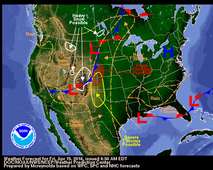
Storms will be boiling and brewing, especially for the plains, midwest and the south starting on Tuesday. The National Weather Service is forecasting a cold front that will bring unsettled weather to the western U.S. into Tuesday with a numerous severe thunderstorms possible near portions of the Plains and Great Lakes on Monday.

Significant and severe thunderstorms will be quite possible across parts of the southern and central great plains Tuesday afternoon into the nighttime hours. According to The Weather Channel’s severe storm expert, Dr. Greg Forbes, there is a substantial possibility of strong, long track tornadoes for central and east Kansas and in portions of central and eastern Oklahoma.

Some of the cities for Tuesday’s storms that will be affected are Dallas-Fort Worth, Hastings, Nebraska, Oklahoma City, Tulsa, Oklahoma and Wichita, Kansas.

Wednesday the storm system will begin moving east, triggering numerous storms from the Missouri Valley to the mid Mississippi Valley, Lower Ohio Valley, the Ozarks and northeast Texas. These areas will have the potential for severe storms, tornadoes, large hail and damaging winds.

The Weather Channel and the National Weather Service are asking that you review your severe weather preparedness and stay tuned to local forecasts to track potentially dangerous weather systems.

Storms Shut Down Most of Houston

The city of Houston, Texas was largely shut down on Monday after a stalled storm system caused severe flash flooding that has schools closed, bus and rail services suspended, and government officials warning residents to stay home.

According to The Weather Channel, rainfall totals were 10-20 inches from southeast Texas to the northwest of Houston. Some places saw 3 to 4 inches of rain per hour. Authorities reported that there were at least 650 residential calls for help on Monday morning.

Harris County Judge Ed Emmett told CNN that there were at least 150 water rescues in Harris County alone, and he suspects there will be more rescues as the flooding gets worse.

CNN also reported as of mid-morning that at least 100,000 homes and businesses were without power in the Houston area, and over 1,000 homes in Harris County were flooded.

Houston Mayor Sylvester Turner told reporters that the Houston area schools were closed along with nine regional hospitals that were closed to additional patients. He added that three apartment buildings had been evacuated, and the residents were taking shelter in a mall. At this time, multiple news outlets have stated that there are no reports of injuries or deaths.

The storm system causing the severe flooding will continue pelting the south through Tuesday before the system moves northwest and weakens. The storm could still produce severe thunderstorms capable of producing hail, strong winds, and even isolated tornadoes, according to CBS News.

Other residents in Mississippi and Louisiana also saw flash flooding according to WISHTV. The Salvation Army, the United Way of Southeast Louisiana, Convoy of Hope, Mercy Chefs, and the Second Harvest Food Bank are all taking donations for the victims of the flooding in Louisiana and Mississippi.

Oklahoma has also seen flooding according Oklahoma City station, KOCO. Approximately 7,000 acres of farmland is under water, and the Washita River is expected to crest Monday evening, bringing even more flooding.

Duo Storms Bring Potential Flooding and Snow to High Plains and Rockies

Duo storm systems over the Midwest and Rockies is likely to produce heavy rainfall capable of flooding, severe thunderstorms, and even snow.

The Weather Channel reports that the High Plains will see severe thunderstorms and even some flooding as the 4-5 day period of rain falls over the area. Some parts of the plains may even set all-time monthly records for April.

Many areas in the Plains from South Dakota to Texas could see at least 3 inches of rainfall through Tuesday evening. Parts of Kansas, Oklahoma, Nebraska, and Texas could see around 5-8 inches of rain over the next few days.

Additionally, this storm could produce severe thunderstorms with large hail, damaging winds, and possibly tornadoes.

And if that weren’t enough, the High Plains may also see snow as Winter Storm Vexo hits the Rockies this weekend.

The National Weather Service has issued winter storm warnings for parts of Utah, Colorado, and Wyoming. So far, The Weather Channel has reported that Nebraska and South Dakota will be the only states in the High Plains to possibly see snow.

Winter Storm Vexo will also bring strong winds that could reach gusting speeds of 30-50 mph and may cause power outages throughout the Rockies and High Plains.

Blizzard watch issued ahead of ‘potentially paralyzing’ snowstorm

The National Weather Service on Wednesday issued its first watches for a winter storm that could wreak havoc on the northeastern United States this weekend.

The blizzard watch includes the cities of Baltimore and Washington and surrounding areas in Maryland and Virginia. It will formally go into effect on Friday afternoon and remain valid through Saturday night, the service said.

The National Weather Service said it’s “monitoring the possibility” that a storm could drop 1 to 2 feet of snow along the I-95 corridor this Friday and Saturday.

The stretch includes other major cities like Philadelphia, Boston and New York, though no watches for those areas had been issued as of mid-day Wednesday.

The service’s Weather Prediction Center warned of a “potentially paralyzing winter storm for portions of the Mid-Atlantic,” including possible blizzard conditions in Baltimore and Washington, and said more than a half-inch of ice was possible in Kentucky and North Carolina. Coastal flooding was also possible.

The blizzard watch cautions that the area could receive more than a foot of snow, with a wintry mix possible on Friday night. The storm is also expected to bring 40 mph wind gusts, which could lead to whiteouts and power outages.

“Heavy snow and blowing snow will cause dangerous conditions and will be a threat to life and property,” the watch states. “Travel is expected to be severely limited if not impossible during the height of the storm Friday night and Saturday.”

The blizzard watch encourages people to stock up on necessary items.

The service also issued less-severe winter storm watches for portions of Pennsylvania, West Virginia and Virginia, though still warned that a foot of snow was possible in some areas and said blowing snow could pose travel hazards.

The Weather Channel is calling the potential storm Winter Storm Jonas.

The threat came as another winter storm was moving across the country.

National Weather Service radar showed precipitation falling throughout the south, and winter weather advisories or winter storm warnings were in effect for portions of Ohio, Kentucky, Tennessee, Virginia, Georgia and the Carolinas.

On Tuesday, Georgia Governor Nathan Deal declared a state of emergency for 15 counties affected by winter weather.

Two killed as tornadoes sweep through Florida

TAMPA, Fla. (Reuters) – Two grandparents were killed and four children injured in Florida early on Sunday when severe storms gusted in from the Gulf of Mexico, spinning off at least two tornadoes, local officials and the National Weather Service said.

Steven Wilson, 58, died when a twister destroyed a mobile home with seven people inside in Duette, Florida, about an hour south of Tampa, the Manatee County Sheriff’s Office said.

Kelli Wilson, 51, escaped with their son and grandchildren. She was later pronounced dead at a hospital, said Dave Bristow, a spokesman for the Manatee County Sheriff’s Office.

She suffered a heart attack, the Bradenton Herald reported.

The four grandchildren – two boys and two girls between the ages of six and 10 – were hospitalized with non-life threatening injuries, according to the sheriff’s office.

One of the children was severely injured, the National Weather Service’s Tampa office reported, confirming that a strong tornado blasting winds up to 127 miles per hour had touched down in the area around 3:30 a.m. ET.

Another tornado was reported further south on Florida’s west coast in Siesta Key, according to the weather service.

The storms dumped heavy rains and blasted strong winds across the state’s central Gulf Coast, but conditions were improving during the day on Sunday.

(Reporting by Letitia Stein; Editing by Ros Russell and Alan Crosby)

Nor’easter could bring 8 inches of snow to parts of New England

A weekend Nor’easter could hit parts of northern New England with up to 8 inches of snow before Saturday afternoon, the National Weather Service warned on Friday morning.

The National Weather Service issued a winter storm watch for northern parts of New Hampshire and Maine, saying a low pressure system off the Atlantic Coast could produce heavy snow in the area. The service said snow was expected to begin falling later tonight and continue through Saturday afternoon, and between 4 and 8 inches were expected to accumulate in those regions.

The National Weather Service also said there was a chance for freezing rain, sleet and rain elsewhere in New England, but had yet to issue any specific warnings as of early Friday. Temperatures in southern New England were expected to remain above the freezing point.

A large storm was bringing rain to the southeastern United States on Friday, and the National Weather Service said it was expected to intensify as it made its way toward New England. But the storm wasn’t expected to bring significant rainfall — forecasts called for a high of about 2 inches in coastal parts of South Carolina. The National Weather Service issued a flash flood watch for those regions.

Separately, the National Weather Service issued winter storm watches for parts of Washington, Oregon and California, as more snow was expected to arrive on Saturday. Snowfall totals were expected to reach 1 to 2 feet on Mount Rainier, according to the National Weather Service, while other mountainous areas of Washington were expected to receive between 6 and 10 inches.

Totals were expected to be lighter in Washington’s valleys, Oregon and California, but still significant. Forecasts were calling for anywhere between 3 and 6 inches of snow in watch areas.

The National Weather Service encouraged people that may be affected by the storm to keep an eye on updated local forecasts.

Alex gusts into first January hurricane in 78 years

TAMPA, Fla. (Reuters) – Hurricane Alex blasted into the record books on Thursday as the first Atlantic hurricane to form during the month of January in more than three-quarters of a century, U.S. weather forecasters said.

The storm, with wind gusts up to 85 miles an hour, was expected to bear down on the Azores islands off the coast of Portugal on Friday, according to the National Hurricane Center in Miami. It did not pose a threat to the United States.

Local authorities issued a hurricane warning for five islands in the central Azores, which could see flash flooding, mudslides and storm surge, said NHC spokesman Dennis Feltgen.

Alex was rated a “Category 1” hurricane, which is the lowest rating on the five-tier Saffir-Simpson hurricane wind scale.

Only two other hurricanes have appeared in January since forecasters began keeping records in 1851, Feltgen said. Hurricane Alice started in December and carried into January in 1955. The last time a hurricane formed in January was 1938.

Still, the early hurricane does not necessarily portend an unusually active storm period during the Atlantic hurricane season from June through November, Feltgen said. That forecast will be determined by weather conditions not yet seen.

“The good news is that even though we have got a hurricane in January, that is not a harbinger of what the 2016 hurricane season will be like,” he said. “It is no reflection.”

(Reporting by Letitia Stein; Editing by Alan Crosby)

New York hit by stretch of lake effect storms, forecasts call for heavy snow

The latest in a stretch of powerful lake effect snowstorms was pummeling upstate New York on Tuesday, with forecasts calling for significant amounts of additional snow in the next two days.

The National Weather Service issued lake effect snow warnings for several counties in western New York, warning that some regions that border Lake Erie and Lake Ontario could see two more feet of snow fall between 10 a.m. Tuesday and 1 p.m. Thursday. Totals were expected to be much lighter further inland, though some communities were expecting about 6 inches of snow.

The latest snow comes on the heels of a lake effect storm that ripped through upstate New York on Monday and dumped 38 inches of snow in Lorraine, a small town about an hour north of Syracuse, according to the National Weather Service. That was the service’s most extreme report of snowfall, though two communities in Erie County reported they received more than foot.

Officials banned all travel in five communities near Buffalo, according to a news release from Governor Andrew Cuomo’s office, as the service called for whiteout conditions this afternoon. Officials also barred unnecessary trips in Erie County and Genesee County, both near lakes.

According to Cuomo’s office, the state Department of Transportation and state Thruway Authority have a combined 793 snow plows, 1,793 employees and more than 188,000 tons of salt available to clear roads. But officials urged motorists to avoid the roads if possible.

While New York was experiencing the most severe storms, it wasn’t the only place impacted by winter weather.

Northern Maine was under a winter storm warning, with the National Weather Service warning that 4 to 8 inches of snow was expected to fall before 10 a.m. Wednesday. Western Michigan was also under a separate winter storm warning with up to 4 inches of snow in Tuesday’s forecast.

The National Weather Service also issued winter weather advisories in parts of Pennsylvania, Ohio, West Virginia, Kentucky, Indiana and Michigan as lighter snow fell across those states.

Another storm in the Pacific Northwest triggered some winter storm warnings and advisories, and National Weather Service forecasts indicated some parts of Washington, Oregon, Idaho, Montana and California could see up to a foot of snow before Thursday evening.

New Forecast Provides Glimpse Into El Niño’s Potential U.S. Impacts

A new forecast provides an in-depth look at the weather conditions that a particularly powerful El Niño is expected to bring to the continental United States over the next three months.

The predictions were recently released by WSI, which has corporate connections to The Weather Channel. The channel analyzed the three-month outlook on its website on Monday.

El Niño is a weather pattern that occurs when part of the Pacific Ocean is warmer than usual, bringing atypical and sometimes extreme weather across the world. Many scientists, including those with NASA and World Meteorological Organization, have publicly said this year’s El Niño is shaping up to be one of the strongest instances of the pattern in the past 65 years, with NASA saying last week it may exceed the strength of the 1997-98 pattern billed as the worst on record.

According to The Weather Channel, the southern United States is generally expected to see temperatures below those typical for this time of year, while the northern states should see hotter-than-usual temperatures. The forecast indicates there may be exceptions to these tendencies, including a stretch this month where temperatures may see a more East-West divide.

El Niño is also known to impact precipitation totals.

Citing the National Oceanic and Atmospheric Administration (NOAA), which researches El Niño and issues its own predictions, The Weather Channel reported states on the Atlantic and Gulf coasts, as well as large chunks of the Great Plains and Southwest, should see above-average precipitation totals this winter. On the other hand, the report indicates states in the Great Lakes and Pacific Northwest, as well as those bordering Canada, may see less rain and snow than usual.

NASA warned last week that the United States likely has yet to see the full brunt of this El Niño, which has already been blamed for several extreme storms across the globe. El Niños also generate droughts in some parts and floods in others, disrupting economies and food supplies.

The forecast analyzed by The Weather Channel focused on general trends, not specific storms.

The NOAA is expected to release its next El Niño update on January 14.

Threat of Major Flooding Shifts Down Mississippi River

Several communities in the central United States were coping with major flooding on Monday morning as the same deadly floodwaters that devastated parts of Missouri moved downstream.

The National Weather Service issued flood warnings all along the lower Ohio, Mississippi and Arkansas rivers as rising waters threatened countless homes and businesses. In certain communities, waters were expected to continue to climb throughout the month before cresting.

One week after a powerful winter storm dumped 6 to 12 inches of rain across much of the region, waters had yet to fully recede from some of the communities they impacted most.

In greater St. Louis, where often-historic flooding forced evacuations and shut down a bustling stretch of Interstate 44, the National Oceanic and Atmospheric Administration (NOAA) said minor flooding was still occurring along parts of the Meramec and Mississippi rivers. Water levels had receded from their record heights in the Missouri communities of Valley Park and Arnold, according to the NOAA, though the flooding had yet to fully stop as of Monday. It could be Saturday before the Meramec finally dropped below flood stage in Arnold., the NOAA said.

Over the weekend, Missouri Governor Jay Nixon’s announced the federal government approved his request to expedite relief efforts after “fast-rising flood water inundated several thousands homes and business and left behind a trail of destruction, debris and refuse” in greater St. Louis, according to a news release. The governor, who had declared a state of emergency and mobilized the National Guard, said the federal aid would help facilitate the cleanup and recovery process.

As some communities began to clean up, others remained partially underwater.

The NOAA reported there was major flooding occurring at 25 river gauges on Monday morning, while another 197 were experiencing minor or moderate flooding. Almost all of them were in the Mississippi River watershed, with downstream communities at risk of water levels rising further.

Major flooding was already occurring in Cape Girardeau, Missouri and the Illinois communities of Thebes and Chester, the NOAA said, and it could be several days before the flooding reduces in severity. According to Cape Girardeau’s official blog, about 25 homes in the city were either flooded or rendered inaccessible by floodwaters that had closed several of the city’s roads.

As the waters left Missouri, they were expected to arrive in Arkansas, Mississippi and Louisiana.

In Natchez, Mississippi, some 580 miles south of St. Louis, the NOAA reported the Mississippi River was already at 49.4 feet, causing minor flooding. The river was expected to rise at least 10 more feet before peaking at 60 feet on January 17, which would spur major flooding issues.

Other areas at risk of major flooding include the Mississippi communities of Vicksburg and Greenville and Arkansas City, Arkansas, according to NOAA projections. The governor of Mississippi, Phil Bryant, preemptively declared a state of emergency amid the threat of floods.

“We are told this flood will be just below the historic record flood of 2011,” Bryant said in a news release. “Our citizens have time to prepare and should begin taking actions now.”

Arkansas Governor Asa Hutchinson’s office said the governor has already declared 38 of the state’s 75 counties disaster areas as a result of storm and flooding damage, and noted the governor could add more counties to the list if the damage calls for the list to be expanded.

The Louisiana Governor’s Office of Homeland Security and Emergency Preparedness has said it would monitor levels of the Red and Mississippi rivers and assist any affected communities.