Storms unleash tornadoes in U.S. east, record snow in Midwest

Dark clouds hover above buildings amidst tornadoes in Fort Lauderdale, Florida, the U.S., April 10, 2018 in this still image obtained from a social media video. Emmet Finneran/via REUTERS

By Rich McKay

ATLANTA (Reuters) – Deadly slow-moving storms generated record or near-record snowfall and low temperatures in the U.S. Midwest and tornadoes further east on Sunday, leaving airline travelers stranded and thousands without power.

In Michigan, where snowfall was expected to reach 18 inches in some areas, about 310,000 homes and businesses were without power because of an ice storm, most of them in the southeast of the state.

Large areas of Detroit were without power and customers were not expected to have it back on Sunday night, utility DTE Energy said. It was working to have 90 percent of outages restored by Tuesday, DTE spokeswoman Carly Getz said in a statement.

Cars are seen on a road during a tornado in Mountainburg, Arkansas, U.S., April 13, 2018 in this picture grab obtained from social media video. JOSHUA COLEMAN/via REUTERS

Cars are seen on a road during a tornado in Mountainburg, Arkansas, U.S., April 13, 2018 in this picture grab obtained from social media video. JOSHUA COLEMAN/via REUTERS

The weight of ice on power lines, coupled with high winds, caused more than 1,000 power lines to fall in Detroit and Wayne County, DTE said.

The worst of the snow was focused on the upper Great Lakes, with Green Bay, Wisconsin, seeing its second largest snowstorm ever after 23.2 inches fell as of Sunday afternoon, the National Weather Service said.

For the twin cities of Minneapolis-St. Paul, Minnesota, the April monthly record for snowfall of 21.8 inches (55 cm) was surpassed on Saturday, the National Weather Service said.

Two tornadoes tore up trees and ripped apart homes in Greensboro and Reidsville, North Carolina, killing a motorist who was hit by a tree, according to Greensboro’s city manager, local media reported.

The storms stretched from the Gulf Coast to the Midwest and were moving into the Northeast and New England.

Record low temperatures for the date were expected in Oklahoma City on Monday at 30 degrees F (-1 C), and in Kansas City, Missouri, at 25 F (-4 C), Hurley said.

On Friday, the weather system produced 17 reports of tornadoes in Arkansas, Louisiana, Missouri and Texas, with four people injured and 160 buildings damaged in a possible tornado in northwest Arkansas, local media reported.

The weather was blamed for two traffic deaths in western Nebraska and Wisconsin, according to National Public Radio.

The storms also killed a one-year-old girl when a tree fell on a recreational vehicle where she was sleeping, the sheriff’s office in Bossier Parish, Louisiana, said.

By Sunday night, 1,804 flights had been canceled into or out of U.S. airports, the website flightaware.com reported, including 148 flights in or out of the Minneapolis-St. Paul airport.

(Reporting by Rich McKay in Atlanta; Additional reporting by Bernie Woodall in Fort Lauderdale, Fla. and Andrew Hay in Taos, N.M.; Editing by Adrian Croft and Peter Cooney)

Weakening Nate brings rain, tornado warnings to U.S. South

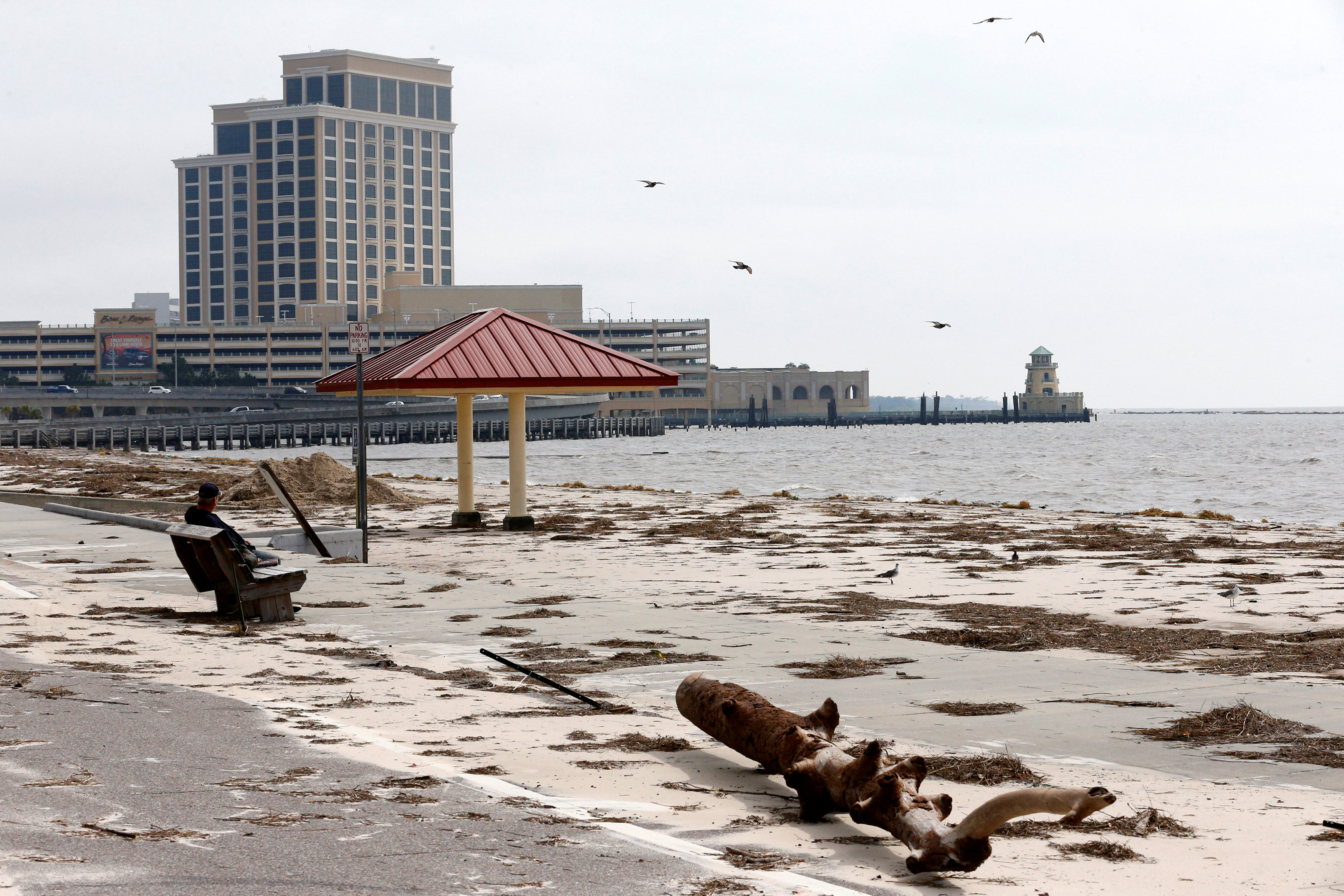
A man sits on a bench overlooking a beach covered in debris scattered by Hurricane Nate, in Biloxi, Mississippi, U.S.,

By Rod Nickel and Jessica Resnick-Ault

BILOXI/PASCAGOULA, Miss. (Reuters) – Hurricane Nate weakened to a tropical depression on Sunday after coming ashore in Mississippi, flooding roads and buildings but sparing the state from catastrophic damages.

Maximum sustained winds from Nate, the fourth major storm to hit the United States in less than two months, dropped to 35 miles per hour (55 km per hour) as it moved through Alabama and into Tennessee.

The remnants of the storm spawned tornado warnings in those states and the western portions of North Carolina and South Carolina. It is forecast to bring gusty winds and up to 4 inches (10 cm) of rain to parts of Ohio, Pennsylvania and New York on Monday.

The storm made landfall as a Category 1 hurricane, the weakest designation by the U.S. National Hurricane Center. Only a few hours earlier, its winds had been blowing at 70 mph (113 kph) but appeared to lack the devastating punch of its recent predecessors.

Mississippi Governor Phil Bryant told reporters there had been no deaths or reports of catastrophic damage. “We are very fortunate this morning and have been blessed,” he said.

Nate killed at least 30 people in Central America before entering the warm waters of the Gulf of Mexico and bearing down on the U.S. South. It has also shut down most oil and gas production in the Gulf.

Nate follows hurricanes Harvey, Irma and Maria, which have devastated areas of the Caribbean and southern United States.

The tropical depression’s center will move up through Alabama into Tennessee and Kentucky through Monday, the hurricane center said. Heavy rainfall and storm-surge flooding remained a danger across the region, and the hurricane center said Florida’s Panhandle and parts of Alabama and Georgia might feel tropical storm-force wind gusts.

The storm was expected to bring three to six inches of rain to parts of western North Carolina through midday Monday, with up to 10 inches possible in isolated spots. Power outages, damaged homes and roads closed by debris were all reported in the region.

Nate made its first U.S. landfall on Saturday evening near the mouth of the Mississippi River and then made a second one early on Sunday near Biloxi, Mississippi.

In Biloxi, water surged over roads during the storm and quickly receded on Sunday, leaving a boat that broke loose marooned on the beach. At a Waffle House restaurant, the storm surge deposited a dumpster in its parking lot.

Jeff Pickich, a 46-year-old wine salesman from D’Iberville, Mississippi, was counting his blessings. Heavy winds left only minor damage, blowing down part of a fence on his rental property in Biloxi.

“I’m just glad,” he said, digging fresh holes for fence posts. “I was afraid of the water. The water is Mother Nature. You can’t stop it.”

Water flowed through Ursula Staten’s yard in Biloxi, pushing over part of her fence and scattering debris, but did not breach her house.

“I have a mess,” the retired massage therapist said. “If we had got Irma, I would have lost everything.”

At the Golden Nugget Casino, one of eight Biloxi gaming establishments, workers rushed to clean up mud, debris and minor damage from 3 feet (1 m) of water sloshing into an entrance and the parkade. The gaming room stayed dry.

Three hundred guests remained in the hotel, some eager to try their luck after surviving Nate.

But dangers from the storm remain, with Florida Governor Rick Scott warning of tornadoes springing up in the Panhandle region and Alabama Governor Kay Ivey urging residents to prepare for strong winds and storm surges.

U.S. President Donald Trump declared federal emergencies in Alabama and Florida on Sunday, which provides additional funding for disaster relief.

Mississippi Power had restored electricity to 10,000 customers, but 4,800 were still without it. More than 1,000 people had arrived at shelters, the state Emergency Management Agency said.

Alabama Power said it had restored electricity to 58,000 of 146,000 customers who lost it.

Rainfall of 3 to 6 inches (8 to 15 cm), with a maximum of 10 inches (25 cm), was expected east of the Mississippi River in Alabama and Tennessee, the hurricane center said.

Residents walk down a street covered in debris scattered by Hurricane Nate, in Biloxi, Mississippi, U.S., October 8, 2017.

Residents walk down a street covered in debris scattered by Hurricane Nate, in Biloxi, Mississippi, U.S., October 8, 2017. REUTERS/Jonathan Bachman

NEW ORLEANS THREAT DOWNGRADED

Forecast at one point to make landfall in Louisiana, Nate headed farther east and spared many New Orleans parishes that were devastated by Hurricane Katrina 12 years ago.

“I had prayed for this – that we would be spared,” said Amos Cormier, president of Plaquemines Parish, Louisiana’s equivalent to a county.

Bernice Barthelemy, a 70-year-old Louisiana resident, died from cardiac arrest overnight after telling Reuters on Saturday that she did not mind having to evacuate, Cormier said on Sunday. He attributed her death to the stress of the move.

New Orleans Mayor Mitch Landrieu said he expected that evacuated residents could return home soon.

Vessel traffic and port operations at New Orleans resumed on Sunday afternoon, while the Port of Mobile in Alabama remained closed. Oil ports, producers and refiners in Louisiana, Mississippi and Alabama were planning reopenings as the storm moved inland on Sunday.

Heavy rain is seen at Orange Beach, Alabama, U.S. as Hurricane Nate approaches, on October 7, 2017 in this still image taken from a video obtained via social media. Jacob Kiper, Owensboro, KY/Social Media via REUTERS

Heavy rain is seen at Orange Beach, Alabama, U.S. as Hurricane Nate approaches, on October 7, 2017 in this still image taken from a video obtained via social media. Jacob Kiper, Owensboro, KY/Social Media via REUTERS

The storm curtailed 92 percent of daily oil production and 77 percent of daily natural gas output in the Gulf of Mexico, more than three times the amount affected by Harvey.

The storm doused Central America with heavy rains on Thursday, killing at least 16 people in Nicaragua, 10 in Costa Rica, two in Honduras and two in El Salvador.


(Reporting by Rod Nickel in Biloxi, Miss. and Jessica Resnick-Ault in Pascagoula, Miss.; Additional reporting by Marianna Parraga, Erwin Seba and Gary McWilliams in Houston; Jonathan Allen in New York; Writing by Lisa Shumaker; Editing by Lisa Von Ahn and Peter Cooney)


U.S. Southeast, Midwest face threat of severe storms, potential tornadoes

Stock photo of a thunderstorm that could produce tornadoes. Courtesy of Pixabay

(Reuters) – A dangerous weather system packing severe thunderstorms was expected to roll through the U.S. Southeast and parts of the Midwest on Wednesday, bringing with it the threat of tornadoes, forecasters said.

The region faced the threat of supercells developing throughout the day as very large hail and damaging straight-line wind appear to be likely, the National Weather Service said in an advisory.

At about 5:30 a.m. local time, a thunderstorm was moving northeast of Anniston, Alabama, at 55 miles (89 km) per hour, bringing with it hail the size of golf balls and 60 mile (98 km) per hour wind gusts, the Weather Service reported.

“For your protection move to an interior room on the lowest floor of a building,” the National Weather Service warned in an advisory.

Kentucky, Tennessee, Alabama, Georgia and South Carolina faced a heightened chance of tornadoes and potential flash flooding during the day.

The 5.7 million people who live in the Atlanta metro area should expect as much as 2-1/2 inches (6 cm) of rain throughout the day and into the evening, the service said.

Dozens of school districts in Alabama and Georgia canceled classes while Alabama Governor Robert Bentley issued a state of emergency ahead of the storm front.

“Alabama is no stranger to the impact severe weather can have on communities and the devastation that can occur when the weather takes a turn for the worse,” Bentley said in a statement.

The severe weather comes days after a powerful storm system in the southeastern U.S. killed four people, including a woman who was swept away by flood waters while she called 911.

(Reporting by Brendan O’Brien; Editing by Chizu Nomiyama)

Treacherous Travel, Snow, Ice, Thunderstorms, Tornado chances

Christmas eve warning map weather.com

By Brendan O’Brien

MILWAUKEE, Dec 23 (Reuters) – Heavy snow, freezing rain and wind gusts will make holiday travel treacherous in swaths of the northern United States.

A storm is expected to bring rain and then snow to the Pacific Northwest as temperatures hover around freezing on Friday night.

The same system will also dump heavy snow in the Rockies and High Plains late into Saturday, the National Weather Service said in its forecast.

Snow and freezing rain are also in the forecast for much of the Midwest and Northeast late on Friday and through Saturday as temperatures are to dip around freezing, the weather service said.

The deteriorating weather may derail travel plans for some of the 94 million Americans who the American Automobile Association say will hit the roads during the holidays.

“Christmas, for travelers, is going to be a little dicey in some portions of the country,” meteorologist Justin Povick said during his forecast on Accuweather.com.

Accuweather warns that blizzard conditions in the northern Plains over the weekend could cause treacherous white-outs along major interstate highways, power outages and airline delays.

“People from the central Plains and middle Mississippi Valley to the central Plains will need to keep an eye out for rapidly changing weather conditions,” Meteorologist Brett Rossio said on AccuWeather.com.

Signs of how bad weather may cause disruptions for holiday travelers were seen as early as Thursday morning as nearly 250 flights were delayed or canceled in and out Los Angeles International Airport due to high winds and high volume.

A blizzard watch is in effect for the area around Bismarck, North Dakota, where as much as a foot (30 cm) of snow fall and heavy winds will lead to “dangerous Christmas travel conditions,” the National Weather Service said.

To the east, in northern Wisconsin and Michigan, motorists are told to “exercise caution” as snow and freezing drizzle are expected to limit visibility and make roads slick, the National Weather Service said.

Tornadoes, thunderstorms and hail are also in the forecast in the southern U.S. Plains, Accuweather said.

As their neighbors to the north deal with winter weather, people in southern Missouri, Kentucky and Tennessee will enjoy unseasonably warm weather on Christmas Day as temperatures are likely to soar into the 60s, according to the National Weather Service.

(Reporting by Brendan O’Brien in Milwaukee; Editing by Alison Williams)


Winter weather to make holiday travel treacherous in northern U.S.

A person walks along Chambers Street during morning snow in Manhattan, New York City,

By Brendan O’Brien

MILWAUKEE (Reuters) – Heavy snow, freezing rain and wind gusts will make holiday travel treacherous in swaths of the northern United States.

A storm is expected to bring rain and then snow to the Pacific Northwest as temperatures hover around freezing on Friday night.

The same system will also dump heavy snow in the Rockies and High Plains late into Saturday, the National Weather Service said in its forecast.

Snow and freezing rain are also in the forecast for much of the Midwest and Northeast late on Friday and through Saturday as temperatures are to dip around freezing, the weather service said.

The deteriorating weather may derail travel plans for some of the 94 million Americans who the American Automobile Association say will hit the roads during the holidays.

“Christmas, for travelers, is going to be a little dicey in some portions of the country,” meteorologist Justin Povick said during his forecast on Accuweather.com.

Accuweather warns that blizzard conditions in the northern Plains over the weekend could cause treacherous white-outs along major interstate highways, power outages and airline delays.

“People from the central Plains and middle Mississippi Valley to the central Plains will need to keep an eye out for rapidly changing weather conditions,” Meteorologist Brett Rossio said on AccuWeather.com.

Signs of how bad weather may cause disruptions for holiday travelers were seen as early as Thursday morning as nearly 250 flights were delayed or canceled in and out Los Angeles International Airport due to high winds and high volume.

A blizzard watch is in effect for the area around Bismarck, North Dakota, where as much as a foot (30 cm) of snow fall and heavy winds will lead to “dangerous Christmas travel conditions”, the National Weather Service said.

To the east, in northern Wisconsin and Michigan, motorists are told to “exercise caution” as snow and freezing drizzle are expected to limit visibility and make roads slick, the National Weather Service said.

Tornadoes, thunderstorms and hail are also in the forecast in the southern U.S. Plains, Accuweather said.

As their neighbors to the north deal with winter weather, people in southern Missouri, Kentucky and Tennessee will enjoy unseasonably warm weather on Christmas Day as temperatures are likely to soar into the 60s, according to the National Weather Service.

(Reporting by Brendan O’Brien in Milwaukee; Editing by Alison Williams)

Tornadoes and hail threaten several central U.S. states

AUSTIN, Texas (Reuters) – The National Weather Service warned that large sections of Texas, Oklahoma and Kansas could be hit by tornadoes, destructive hail and high winds on Tuesday, prompting some school districts to send students home early.

Hail about the size of golf balls hit several places in Kansas and Missouri on Tuesday, the service said. This comes after hail storms in Texas in late March and April hit major cities such as Dallas, Fort Worth and San Antonio, causing damage estimated to be several billion dollars.

“Locally damaging wind and marginally severe hail also may occur from the lower Missouri and lower Ohio Valleys to the mid-Atlantic coast,” the National Weather Service said.

Schools in Oklahoma City and several of its suburbs planned to close early on Tuesday, ahead of the severe weather expected to come in the afternoon.

The National Weather Service also issued a severe thunderstorm watch for large parts of Missouri and southern sections of Illinois as a storm front moves through the region.

(Reporting by Jon Herskovitz; Editing by Marguerita Choy)

Storms and Tornadoes brewing into Wednesday

Forecast of where thunderstorms will be most likely on Tuesday.

Storms will be boiling and brewing, especially for the plains, midwest and the south starting on Tuesday. The National Weather Service is forecasting a cold front that will bring unsettled weather to the western U.S. into Tuesday with a numerous severe thunderstorms possible near portions of the Plains and Great Lakes on Monday.

Significant and severe thunderstorms will be quite possible across parts of the southern and central great plains Tuesday afternoon into the nighttime hours. According to The Weather Channel’s severe storm expert, Dr. Greg Forbes, there is a substantial possibility of strong, long track tornadoes for central and east Kansas and in portions of central and eastern Oklahoma.

Some of the cities for Tuesday’s storms that will be affected are Dallas-Fort Worth, Hastings, Nebraska, Oklahoma City, Tulsa, Oklahoma and Wichita, Kansas.

Wednesday the storm system will begin moving east, triggering numerous storms from the Missouri Valley to the mid Mississippi Valley, Lower Ohio Valley, the Ozarks and northeast Texas. These areas will have the potential for severe storms, tornadoes, large hail and damaging winds.

The Weather Channel and the National Weather Service are asking that you review your severe weather preparedness and stay tuned to local forecasts to track potentially dangerous weather systems.

Weekend Weather Promises Big Mix

This weekend weather promises a big mix of severe storms, snow, flooding and tornadoes. With a storm system moving across the Central and Southern Plains, a cold front on the East Coast and freezing weather setting in across numerous locations, you don’t have to go far for something different in your weather conditions.

According to the National Weather Service, The western U.S. will remain mostly dry through the weekend as high pressure remains in places across the region. Severe thunderstorms in the central and southern plains will produce hail, damaging winds and some tornadoes. This system will also produce flash flooding and snow over portions of the upper great lakes and central rockies.

The Weather Channel reports that multiple rounds of strong to locally severe storms are possible from Delaware and southeastern Virginia to the Carolinas, south/central Georgia, northern Florida, southern Alabama, southern Mississippi, and southeast Louisiana, as a cold front slowly pushes southeast.

A few thunderstorms may also develop farther north into Pennsylvania, New Jersey, New York and New England. The potential impacts of these storms could be damaging wind gusts and large hail, though a few tornadoes are possible.
Flash flooding will remain a threat from the Carolinas and Georgia, southern Alabama, the Florida panhandle, coastal Mississippi and southeast Louisiana.

The National Weather Service also reported that heavy rain and strong storms were expected for the Southeast states and snow with much colder temperatures will be the norm from the upper midwest to the Northeast this weekend.

Several tornadoes were reported in Mississippi and Alabama Thursday evening as a multi-day round of severe weather clobbered the South, and the threat persisted Friday morning into Georgia in reports by The Weather Channel.

One twister touched down in Lowndes County, Mississippi, near New Hope before rising off the ground and touching down again across the state line in Alabama near Ethelsville. Lowndes County Emergency Management Service Director Cindy Lawrence told the Associated Press that at least a dozen homes near New Hope were damaged by the storm, but there were no injuries. Survey crews from the National Weather Service found two EF1 tornadoes hit northern Pickens County in Alabama.

A Mississippi teen was killed earlier in the day Thursday in a wreck on wet roads.

For those of you experiencing any severe weather in your area, please stay tuned to your local weather stations for up to date information.

Five dead in storms in U.S. South as floods continue

SHREVEPORT, La. (Reuters) – The death toll from storms in Southern U.S. states rose to five as storm-weary residents of Louisiana and Mississippi watched for more flooding on Monday from drenching rains that inundated homes, washed out roads and prompted thousands of rescues.

Flood waters across Louisiana were blamed for four deaths and damage to at least 5,000 homes, and one person drowned in a flooded area in Oklahoma last week. Flood warnings were in effect as rivers, bayous and creeks stayed high after storms dumped more than 20 inches of rain in some places.

In Louisiana, Harold Worsham, 78, drowned in Saline Bayou when his boat capsized as he tried to remove items from a home as waters rose on Saturday night, according to the Natchitoches Parish Sheriff’s Office.

Many rivers and lakes in northern Louisiana have risen to historic levels and homes there face the threat of yet more flooding, said Matt Hemingway, a National Weather Service meteorologist in Shreveport.

“It’s going to take some time for them to fall back down below flood stage,” he said. “Some folks may be in this situation not just days but weeks.”

Authorities and meteorologists described the flooding as some of the worst seen in the region apart from that spawned by hurricanes. President Barack Obama declared flooding in Louisiana a major disaster on Sunday, activating federal aid.

The Louisiana National Guard said it had rescued more than 3,000 people and 300 pets.

Weldon Thomas, who lives in the Lake Bistineau area, said the flood was devastating for many of his neighbors.

“This is the worst flood that these people have ever seen, and some of them have been there 60 or 70 years,” he said. “It’s a tragic situation for everybody.”

In Bossier Parish, several feet of water covered low parts of normally busy Highway 71 and water rose to the top of road signs. Stranded livestock huddled on patches of dry land.

Emergency officials in Mississippi said flooding threatened to close interstates 59 and 10, which they warned could result in major traffic congestion.

As of Sunday afternoon, 185 homes were destroyed or significantly damaged in Mississippi and about 650 more sustained minor damage, according to the state.

Mandatory evacuation orders issued by authorities in the Texas county of Newton, which borders Louisiana, remained in effect for people living near the Sabine River over flood dangers.

(Additional reporting and writing by Colleen Jenkins and Curtis Skinner; Editing by Dan Grebler and James Dalgleish)

Tornado reported, flash flood watches expanded as severe weather targets South

Portions of the Southern Plains on Tuesday morning were beginning to feel the force of the thunderstorms and flash flooding that is expected to hit the region over the next few days.

National Weather Service radar showed rain falling across Texas and Oklahoma, the beginning of a series of thunderstorms forecast to bring up to 10 inches of rain to the South by Thursday.

The service said the thunderstorms could also generate tornadoes, and its Storm Prediction Center had already received one report of a funnel cloud in Texas by 10 a.m. Central Time.

A tornado watch was in effect for 31 counties in Texas. It was set to expire at 1 p.m. today.

Other counties in the Dallas-Fort Worth area were under warnings and watches for severe thunderstorms, and the service advised high wind gusts and penny-sized hail were possible.

The National Weather Service also expanded its flash flood watches to larger parts of Texas, Oklahoma, Arkansas and Louisiana, warning waters could rise quickly in those areas. The highest rainfall totals are still expected in East Texas, Western Louisiana and Southwest Arkansas, but updated forecasts show parts of Missouri and Oklahoma could receive 4 inches.

Many of the flash flood watches are slated to begin this afternoon and continue through Thursday, though residents of the affected areas should monitor their local forecasts.

The service’s Storm Prediction Center said communities in South Texas, as well as those along the state’s Gulf Coast, had the highest risk of experiencing severe thunderstorms today. It said there was an “enhanced” risk of the storms in those areas, the middle level on a five-tier system.

But the tornado was reported in Tolar, which is located about 80 miles southwest of Dallas.

The Storm Prediction Center had received at least 10 reports of high winds as of 10 a.m. Central Time, all in North Texas. The reports indicated that gusts of up to 70 mph were recorded in Tarrant County, where a roof was blown off a business and large branches fell on a sidewalk.

Utility company Oncor said about 36,000 of its customers in the Dallas-Fort Worth area were without power as of 10 a.m. Tuesday. And flight monitoring website flightaware.com said some 230 flights to or from Dallas-Fort Worth International Airport had been delayed by that time.