Schools shut, supplies affected as Madrid clears record snow

By Cristina Sanchez and Belén Carreño

MADRID (Reuters) – Schools in Madrid were shut and some supermarkets ran out of fresh produce or were shuttered on Monday but most trains and flights had resumed operations after a huge snow storm hit the Spanish capital and several other regions over the weekend.

While many people enjoyed the rare snowfall, skiing in the very center of Madrid and holding mass snowball fights, a further cold spell was set to turn the snow into ice this week and authorities rushed to clear more streets, though they said the efforts could take one or two weeks.

Residents of Madrid, which has seen its heaviest snowfall in at least 50 years, helped police open paths through deep banks of snow using plywood boards or trays, and poured salt on the underlying ice. With rooftops enveloped in snow, authorities cordoned off some pavements due to the risk of accidents.

The storm, which dumped up to 20 inches on Madrid, has hampered Spain’s efforts to increase the pace of its coronavirus vaccination program amid rising infections.

A new batch of vaccines meant to land in Madrid was diverted on Monday to Vitoria in the north, but city authorities said vaccinations in care homes and hospitals continued as planned.

Renfe train operator said all fast train lines were operating except for Madrid-Barcelona connections, which are likely to resume early in the afternoon. Most Madrid suburban lines were working on Monday, but with fewer trains than usual.

“COMPLICATED SITUATION”

Two runways at the Barajas international airport re-opened. The airport operator said that of around 400 flights scheduled to fly in and out on Monday, 117 had been cancelled.

A Reuters reporter saw a number of empty shelves at several central Madrid supermarkets.

The Spanish supermarket association urged customers to behave responsibly in the wake of a “complicated situation” in many storm-affected areas. But it said supplies had resumed in the early hours on Monday and were gradually increasing.

After staying closed in the morning, Mercamadrid, the city’s main wholesale food market, said convoys of trucks which had been stranded in the snow since Friday had started arriving and that it was preparing to resume activity from Monday night.

About 85% of Madrid’s bars and restaurants are still closed, with a return to normal expected on Thursday, the Hosteleria de España association said, estimating lost revenues over the period at 70 million euros ($85 million)

Interior Minister Fernando Grande-Marlaska said the situation on the roads was improving but was still “extraordinary” and many remained closed.

The cold wave, with temperatures as low as -10 degrees Celsius in central Spain, will last until Thursday, the Aemet meteorological agency said.

($1 = 0.8223 euros)

(Reporting by Guillermo Martinez, Elena Rodriguez, Ingrid Melander, Cristina Sanchez, Belen Carreno, Inti Landauro, Clara-Laeila Laudette, Emma Pinedo, Andrei Khalip; Writing by Ingrid Melander and Andrei Khalip; Editing by Raissa Kasolowsky and Gareth Jones)

Winter storm set to deliver disruptive blow to U.S. Northeast

By Peter Szekely

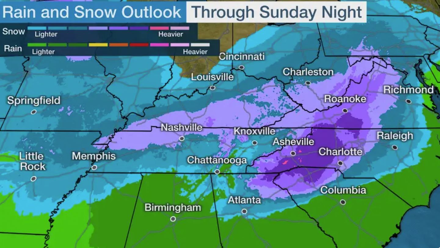
NEW YORK (Reuters) – A major winter storm was making its way up the U.S. East Coast on Wednesday, ready to deliver a disruptive blow to the region, with up to 2 feet (60 cm) of snow in parts of the Northeast and freezing rain in some Mid-Atlantic areas, forecasters said.

The Nor’easter, which was already bringing a wintry mix of precipitation to Virginia and North Carolina early in the day, was moving up the coast that is home to more than 50 million people before exiting the Boston area on Thursday afternoon, they said.

Meteorologist Bob Oravec of the National Weather Service’s Weather Prediction Center in College Park, Maryland, said the forecast could have been worse if not for the speed at which the system was traveling.

“It’s not a slow-moving system at all, so it’s not going to be a very prolonged snow event,” Oravec said by phone.

Ground zero for snow accumulation is an area that includes several ski resorts stretching from central Pennsylvania to upstate New York, where 18 to 24 inches was expected, Oravec said.

“Typically, when you have a big snowstorm like this, you can have snow totals one to two inches plus per hour,” he added.

But a much larger area that includes the New York City area is likely to get more than a foot of snow, he said.

New York City officials began warning residents on Tuesday of the potential for hazardous travel and urged people to stay off the roads.

Mayor Bill de Blasio said on Tuesday that it was shaping up to be the first major snowstorm in a couple of years, “and people need to take it seriously.”

New York City schools, which just recently reopened their classrooms after a brief pandemic-induced shutdown, were set to go fully remote on Thursday when students are likely to wake up to more than a foot of snow on the ground, de Blasio said. The snow could significantly reduce visibility and potentially cripple travel in places, while winds of up to 50 miles per hour (80 km per hour) could down trees and power lines, causing power outages, the weather service said.

Many areas of North Carolina and southwestern Virginia were expected to get freezing rain that will leave a quarter-inch of ice on the roads, the service said.

(Reporting by Peter Szekely in New York; Additional reporting by Brendan O’Brian in Chicago)

Heavy snow in U.S. West and Midwest could disrupt post-Thanksgiving travel

(Reuters) – A major winter storm will lumber across the United States over the weekend, dumping snow as it moves east from the U.S. West and threatening to disrupt millions of people traveling home after celebrating the Thanksgiving holiday.

Over a foot of snow is forecast in mountainous parts of Colorado, Utah and Arizona on Friday before the storm system slips toward the upper Midwest, the National Weather Service said.

Freezing rain will likely turn to snowy blizzards in parts of Minnesota, Wisconsin and Michigan beginning on Friday night, with more than 18 inches of snowfall possible in some mountainous areas, the service said.

Some snow could appear in the Northeast by Sunday morning, the service said. New York City and other places further down the Atlantic Coast can expect a wintry mix of precipitation on Sunday.

More than 4 million Americans were expected to fly and another 49 million expected to drive at least 50 miles or more this week for Thanksgiving, according to the American Automobile Association.

Wintry weather disrupted travel this week ahead of Thursday’s Thanksgiving celebrations, with airports in Minneapolis and Chicago reporting hundreds of delayed or canceled flights.

(Reporting by Jonathan Allen in New York; Editing by Chizu Nomiyama)

Frozen harvest leaves bitter taste for U.S. sugar beet farmers

By Rod Nickel

HALLOCK, Minn. (Reuters) – Weather during harvest season in the U.S. Red River Valley, a fertile sugar beet region in Minnesota and North Dakota, has to farmers felt like a series of plagues.

Rain and snow pelted crops in September and October. That was followed by a blizzard, and then warm temperatures that left fields a boggy mess. Next came a deep freeze, ruining the underground sugar beet crop, and dealing a harsh blow to farm incomes.

“I can take a couple of perils from Mother Nature and after that I’m on my knees,” said Dan Younggren, 59, who was unable to harvest 500 acres (200 hectares) of sugar beets, or 40% of his plantings near Hallock, Minnesota. “We’ve never had a situation like this.”

Extreme weather has hampered planting and harvesting of corn, soybeans, and other crops throughout 2019 across the United States and Canadian farm belts.

But in Minnesota and North Dakota, which accounted for 56% of the U.S. sugar beet acres this year, the freeze is a double whammy.

Sugar beet growers’ contracts with processors, which operate as farmer-owned cooperatives, require those who leave unharvested acres to pay a fee to the cooperative so it can pay its bills in leaner years.

Younggren’s five-generation farm must pay American Crystal Sugar a fixed cost of $343 for every unharvested acre, totaling roughly $171,500 to be docked from payments for beets he did harvest.

On Monday, the U.S. government authorized the import of an additional 100,000 short tons of Mexican refined sugar due to the harvest issues. The United States is the world’s third-largest sugar importer after Indonesia and China, buying 2.8 million tonnes in 2018-19, according to the U.S. Department of Agriculture.

Producers Western Sugar Cooperative and United Sugars Corp issued force majeure notices this month. Other processors also face a difficult winter.

At American Crystal Sugar’s factory in East Grand Forks, Minnesota, farmer David Thompson circled the yard in his pickup, surveying snow-covered mounds of sugar beets.

“Normally this time of year you would see piles everywhere,” said Thompson, who left 170 acres unharvested. “This is heart-wrenching for me to see the yards this empty.”

American Crystal, the largest U.S. sugar beet processor, did not respond to requests for comment.

Cargill Inc, one of the largest U.S. refined sugar suppliers, has adequate supply of cane sugar for its Louisiana refinery, but may import more sugar if customers need it due to the poor beet harvest, said Chad Cliff, the company’s global sugar product line lead.

Crop insurance will compensate farmers for some of their yield loss, but there is no program that will allow them to recoup the fixed cost fees, said Thompson.

It is too soon to know the extent of crop damage, said Luther Markwart, executive vice-president of Washington-based American Sugarbeet Growers Association. Farmers could potentially seek assistance under the Wildfires and Hurricanes Indemnity Program, which farmers have not used before for field crops damaged by rain and cold, he said.

In towns across the Red River Valley, the sugar farm disaster has left few people untouched.

“It’s going to affect everyone from the grocery store to the restaurant to the liquor store,” said Chip Olson, the part-time mayor of Drayton, North Dakota, population 760.

Many of the town’s residents work in its Crystal Sugar plant, and usually have seasonal jobs until late spring. This year the work will likely run out months earlier, Olson said.

The combination of rains, thaws and the freeze made the beets unusable. Wade Hanson, who grows sugar beets with his family near Crookston, Minnesota, was unable to harvest half of the farm’s plantings, or 500 acres, this year.

“My dad always told me, ‘we always get the beet crop off.’ This year it didn’t happen and that was pretty shocking.”

(Reporting by Rod Nickel in Hallock, Minnesota; Editing by David Gaffen and Marguerita Choy)

Powerful storm sweeps across northern U.S. plains bringing snow, high winds

(Reuters) – A powerful snowstorm swept across parts of the central and northern U.S. plains in unseasonably cold temperatures and high winds on Thursday, forcing school closures and dozens of vehicle crashes on slick roads across the region.

The system was expected to produce up to 2 feet (61 cm) of snow in parts of central and eastern North Dakota and up to 10 inches of snow in portions of Nebraska, South Dakota and Montana through Saturday evening, the National Weather Service (NWS) said.

“It is significant, historic amounts for this time of year” in North Dakota, said NWS meteorologist Renee Wise.

The heavy, wet snow was accompanied by sleet and ice, making road travel treacherous if not impossible in some areas, the weather service said.

“It makes it more difficult to shovel and travel in. Some people were saying that with the snow on the roads this morning it was little bit like wet concrete mix,” Wise said.

Temperatures were forecast to dip into the teens while wind gusts were expected to reach 40 mph (65 kph) in parts of the region, the NWS said.

A blizzard warning was issued for communities in northern North Dakota from 10 a.m. Friday until 1 p.m. Saturday. The NWS said it expected three feet of snow and wind gusts to reach 60 mph, causing whiteout conditions and impassable drifts.

Winter storm, high wind and freeze warnings were also in effect for much of the U.S. Plains, from North Dakota south through Kansas and into Oklahoma and into northern Texas as of Thursday afternoon, with some warnings extending into Saturday.

In the Denver metro area, icy roads on Thursday caused dozens of crashes and semi-trucks to jackknife, closing some highways. Conditions were expected to worsen throughout the day as the city was expecting three inches of snow, the Denver Post reported.

“Tons of cars sliding everywhere, even trucks – really scary and unsafe!!,” said a Twitter user named Mehgan Russell, who said they lived in Denver.

The snowstorm forced schools to close in Denver on Thursday after schools were closed in Spokane, Washington, on Wednesday.

Some 136 flights were delayed and another 24 were canceled at Denver International Airport due to snow and ice, the online tracking site FlightAware.com reported.

(Reporting by Brendan O’Brien in Chicago)

Record snow, cold, slams northern U.S. Rockies with winter-like weather

Record snow, cold, slams northern U.S. Rockies with winter-like weather
(Reuters) – Midwinter-like weather clobbered the northern Rockies Sunday and into Monday, making early Autumn feel like deep winter, while as much as 4 feet (121 cm) of snow fell in places and hard-hit Montana declared a state of emergency to clear blocked roads.

“You have to go back to the 1930s before you find another storm like this, this early in the season,” said Josh Weiss, a meteorologist with the National Weather Service’s (NWS) Weather Prediction Center.

“A pretty good swath of the northwest got 2-3 feet (60-91 cm) of snow,” Weiss said. “It’s a pretty good storm.”

About 19 inches of snow fell in northwestern Washington state, and light snow also fell in areas of California, Nevada, Wyoming, Oregon and Idaho, forecasters said.

Another 1-2 inches (2.5 – 5 cm) of snow was expected by mid-Monday in spots, with winter storm warnings in effect for western Montana and the mountains of northern Washington and northern Idaho.

Montana Governor Steve Bullock called an emergency on Sunday after 40 inches (101 cm) of snow fell in towns like Browning, forcing highway closures and a string of road accidents.

Temperatures dropped to record lows in the 20s F (-6.6 C) or below on Sunday night across western Montana and north-central Idaho, according to the NWS.

“With an unprecedented winter storm throwing our state a surprise in September, state and local governments are working closely together to protect the health and safety of Montanans,” Bullock said.

Strong winds blowing snow were expected to disrupt travel early Monday.

“The good news is that the storm is winding down,” Weiss said. “But it’s going to linger this morning.”

(Reporting by Rich McKay in Atlanta and Andrew Hay in Taos, New Mexico; Editing by William Maclean)

Blizzard clobbers Plains and Midwest after blanketing the U.S. Rockies

A bicyclist exits the Midtown Greenway bicycle and pedestrian trail during the spring snowstorm in Minneapolis, Minnesota, U.S., April 11, 2019. REUTERS/Annabelle Marcovici

By Keith Coffman

DENVER (Reuters) – A powerful blizzard slammed the U.S. Plains and Midwest on Thursday with heavy snow and fierce winds that caused power outages and closed highways while raising fears of more flooding in the Midwest after a deluge last month.

The system was dumping more than a foot (0.3 m) of heavy snow and winds were gusting up to 65 miles (105 km) per hour from northeast Colorado north to northern Wisconsin, the National Weather Service said in multiple advisories.

Whiteout conditions on roadways were making “travel extremely dangerous,” according to the weather service. Blizzard and winter storm warnings would remain in effect across the region through Friday morning, it said.

“Conditions will continue to deteriorate the rest of the afternoon and overnight,” said Dan Effertz, a NWS meteorologist in Minnesota. “This is a very potent storm.”

Local media reported dozens of crashes and cars in ditches as several major highways and roads were shut down in parts of the U.S. Plains and Midwest. Some counties issued “no travel” advisories, warning drivers to stay off the roads.

“Blizzard, day two. Not even the pack of sled dogs can handle these roads,” said Minnesota crime novelist Anthony Neil Smith on Twitter.

More than 30,000 homes and businesses were without power in Minnesota, 14,200 in Iowa and 22,700 in Michigan by midday on Thursday, according to PowerOutages.us, a website that tracks power outages.

The storm beginning on Wednesday has already dumped more than 2 feet of snow on parts of South Dakota and more than about a foot of snow in communities in Wyoming, Montana and Colorado.

The storm caused officials to close schools and governmental offices in dozens of communities.

In addition to snow, the storm was bombarding the region with rain, sleet, freezing rain and thunderstorms.

“You can probably even throw in the kitchen sink at this point,” the weather service said in a Tweet.

The blizzard, dubbed a “bomb cyclone” because of its rapidly intensifying funnel shape, is the second one to hit the region over the past month.

In March, another “bomb cyclone” triggered heavy rain over the region and combined with melting snow to cause flooding along the Missouri River and its tributaries. Damages and losses to property, cattle and crops in Nebraska and Iowa alone were estimated at more than $3 billion.

Officials in Nebraska on Thursday were cautiously watching the forecast and river levels to the north, said Jodie Fawl, a spokeswoman for the Nebraska Emergency Management Agency.

“We are waiting to see what happens when the snow melts,” she said, noting that warm temperatures since then have thawed the ground and could result in less flooding. “We are just going to have to wait and see.”

Despite the severe weather, crew members at Denver International Airport worked through the night to remove snow from runways, and only about 180 flights were canceled on Thursday morning, down from more than 700 a day earlier, according to FlightAware.come, a flight tracking service, and airport officials.

(Additional writing and reporting by Rich McKay in Atlanta and Brendan O’Brien in Milwaukee; additional reporting by Andrew Hay in Taos, New Mexico, Gina Cherelus in New York and Alex Dobuzinskis in Los Angeles; editing by Bernadette Baum and Phil Berlowitz)

Historic blizzard wanes as it barrels east after pounding parts of U.S.

A general view of the blizzard in Greeley, Colorado, U.S. March 13, 2019 in this picture obtained from social media. Mandatory credit TWITTER @PHOTOWILLG/via REUTERS

By Keith Coffman

DENVER (Reuters) – A blizzard of “historic proportions” that hit the U.S. Rocky Mountain and Plains states this week was moving eastward on Thursday as it weakened, hurling hurricane-force winds and heavy rain on its way, weather officials said.

“While the storm has reached its lowest pressure and will gradually weaken over the next few days, strong winds will continue on the west side of the storm across portions of the Central and Northern Plains,” Bob Oravec, a meteorologist with the National Weather Service (NWS), said on Thursday in a weather advisory.

A day earlier, the NWS had described the cyclone as being of ‘historic proportions’ in a post on Twitter. Hurricane-force winds involve frequent gusts or sustained winds of more than 74 miles per hour.

The blizzard, bringing severe snowfall, poor visibility and powerful winds, caused hundreds of flight cancellations and thousands of power outages in Colorado and Texas. It was expected to unleash similar conditions over areas in Colorado, Wyoming, Nebraska, South Dakota and North Dakota before moving into northwest Minnesota, Oravec said.

While some flights resumed at Denver International Airport, the airport was not expected to be fully operational until midday on Thursday, as airlines were still dispatching more planes to Denver to replace those diverted or canceled earlier, airport spokeswoman Emily Williams told Reuters.

Flight cancellations were down to more than 600 on Thursday morning, from more than 1,300 in the region a day earlier, according to FlightAware.com.

Power outages in Colorado affected about 80,000 homes and businesses, down by 8,000. About 60,000 in Texas also experienced outages on Thursday, dropping by 17,000.

Stranded motorists across the region had been reached and given assistance before midnight, a spokesman for the Colorado State Patrol spokesman said early Thursday. Around 1,100 motorists were reported as stranded on Interstate 25 near Colorado Springs a day earlier.

A state of emergency was still in effect in Colorado as cities and towns dug out from the storm, during which strong, 70-mile-per-hour wind gusts pushed tractor trailers sidewise and left up to two feet of snow in some areas.

The storm was blamed for the death of a Colorado state trooper, who was hit by a car that slid on ice on the highway as he was attending to a car wreck.

Schools and government offices remained closed Thursday across the region.

The blizzard, previously dubbed a “bomb cyclone” by U.S. meteorologists for its quick, late-season punch, was still expected to prompt warnings of blizzards and snow before noon in north-central Kansas and Nebraska, Brian Hurley, a meteorologist with the National Weather Service, said early on Thursday.

Remnants of the snowfall and rain would clear from Denver and the mountain and plains areas by midday, he said.

(Reporting by Keith Coffman in Denver; writing and additional reporting by Rich McKay in Atlanta and Gina Cherelus in New York; Editing by Bernadette Baum)

Schools shut, flights canceled as storm sweeps U.S. Midwest, East Coast

A local resident removes snow from a car during a winter storm in Washington, U.S., February 20, 2019. REUTERS/Carlos Barria

(Reuters) – A winter storm swept across much of the U.S. Midwest and East Coast on Wednesday, hampering air travel and prompting officials to close federal offices in Washington and several large public school systems.

The National Weather Service warned the storm could make travel very difficult, with snow, sleet and freezing rain potentially causing downed branches and power outages.

The storm reached from northern Minnesota down through Missouri and east into the Mid-Atlantic region and could bring as much as 6 inches (15 cm) of snow along with sleet and freezing rain, the National Weather Service said in an advisory.

The storm forced the closing of federal agencies in Washington as well as schools in Philadelphia, Baltimore and Washington.

Hundreds of flights were delayed or canceled in and out of major airports in Washington, Philadelphia and Chicago, according to Flightaware.com. Airports told passengers on social media to check their airlines for delays and cancellations.

(Reporting by Brendan O’Brien in Milwaukee; Editing by Jeffrey Benkoe)

‘Pineapple Express’ storm douses California with rain, snow

Snow capped mountains are seen behind the downtown Los Angeles skyline, California, U.S., February 12, 2019. REUTERS/Lucy Nicholson

By Andrew Hay

(Reuters) – A Pacific storm system known as the “Pineapple Express” threatened to dump up to 8 inches of rain and 8 feet of snow on areas of California, raising risks of flooding and mudslides, meteorologists said on Wednesday.

“The (Pineapple) Express is no joke,” said Bob Oravec, meteorologist with the National Weather Service’s Weather Prediction Center in College Park, Maryland of the strongest weather system of the season.

The weather system, also known as an atmospheric river, gets its name from the flow of moisture that periodically heads east from waters adjacent to the Hawaiian Islands to soak the U.S. West Coast. It blanketed parts of Hawaii with snow over the weekend and is expected to drench California.

The San Francisco Bay area could be hit by flash flooding and falling trees as saturated ground gets up to 8 inches more rain and strong winds blow in, the weather service said.

“We’re talking 3 to 5 inches of rain in San Francisco and coastal areas in just the next 24 hours, and more on into Friday,” Oravec said.

To the northeast in the Sierra Nevada Mountains, passes could see between 80 and 100 inches (approximately 7 to 8 feet) of snow through Friday.

Valley areas face flood watches over fears the relatively warm Pineapple Express system could initially drench areas as high as Lake Tahoe with rain, melting snow and swelling rivers.

WILDFIRE BURN AREAS

The Central and Southern California coast can expect flash flooding and possible mudslides near recent wildfire burn areas, the NWS reported.

Oravec said that the problem is not just the amount of rain, but the fact that it will hit in a short amount of time.

“It’s going to be heavy and fast,” he said. “Debris flows and mudslides are a risk in any area scorched by the wildfires. There’s little to no vegetation to slow that water down.”

Up to 2 inches of rain was expected in the Los Angeles area between Tuesday evening and Thursday morning, the weather service said.

A string of winter storms has swelled snowpack in California to above-average levels, delighting farmers in need of water and skiers in search of powder.

(Reporting by Andrew Hay, additional reporting by Rich McKay, editing by Louise Heavens)