Several tornadoes spotted and warnings of isolated hail ahead of category 5 Hurricane Milton

Tornado ahead of Hurricane Milton

Important Takeaways:

  • The National Weather Service (NWS) in Miami has issued a tornado watch and several tornado warnings for parts of Florida as Hurricane Milton rapidly approaches west-central Florida.
  • On Wednesday morning, the NWS reported several tornadoes, including one crossing the I-75 highway, and urged residents to seek shelter immediately.
  • The tornado watch remains valid until Wednesday evening at 9pm ET and covers parts of south Florida
  • Videos and pictures posted online showed several of the spotted tornadoes growing in size as they move across south Florida.
  • The agency also warned that isolated hail up to a 0.5in size is possible, along with isolated gusts of wind traveling up to 70mph.
  • Approximately 12.6 million residents face potential exposure to the tornadoes, in addition to 2,424 schools and 170 hospitals.
  • The tornado watch and warnings come as the category 5 Hurricane Milton is expected to double in size as the “storm of the century” by the time it makes landfall late Wednesday or early Thursday.

Read the original article by clicking here.

Central Plains brace for severe storms

Luke 21:25 ““And there will be signs in sun and moon and stars, and on the earth distress of nations in perplexity because of the roaring of the sea and the waves

Important Takeaways:

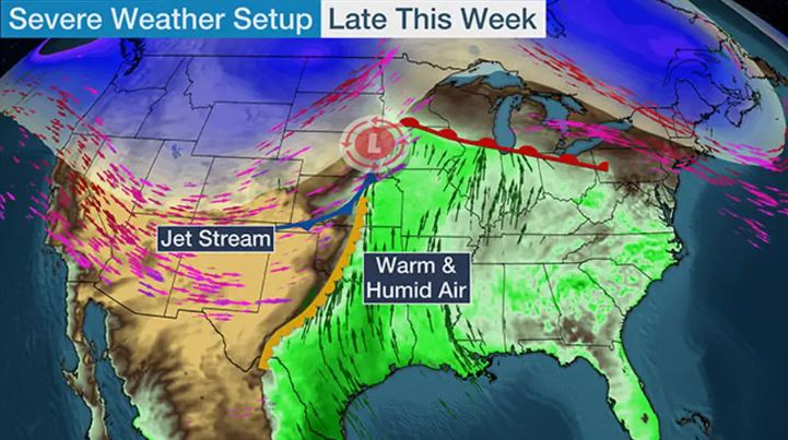
  • Strong tornadoes, destructive hail possible as severe storms threaten central, southern Plains
  • The multiday severe weather threat continues Thursday across the central and southern Plains, where thunderstorms packing strong tornadoes and destructive hail are possible during the afternoon and evening.
  • The Denver metro was pounded by hail on Wednesday amid severe storms that prompted the area’s first Tornado Watch in nearly two years.
  • On Thursday, the threat of severe storms shifts a bit farther east in the Plains, extending from the Dakotas to North Texas, with a separate area of strong thunderstorms expected along the Gulf Coast and into Florida. This places more than 25 million people at risk of dangerous weather.
  • The most intense storms will likely be centered over portions of western and central Kansas, including Wichita, and southward into central Oklahoma, including Oklahoma City and Tulsa, shaded in the darkest red on the map below.

Read the original article by clicking here.

Tornado flattens small town in Oklahoma; leaves trail of destruction into Kansas

Tennis Ball size hail

Luke 21:25 ““And there will be signs in sun and moon and stars, and on the earth distress of nations in perplexity because of the roaring of the sea and the waves

Important Takeaways:

  • Monster supercell tornado rips through Midwest killing two and flattening Oklahoma town bringing hail the size of tennis balls and creating a 19,000 ft high ‘debris ball’: 20,000 are still without power
  • A tornado has left a trail of destruction across Oklahoma and Kansas, killing at least two people, levelling homes and leaving tens of thousands without power
  • Several other states are under severe weather watches as the twister system continues to leave a trail of destruction across the Midwest
  • The terrifying twisters tore through the Midwest Wednesday evening, while parts of Nebraska, Missouri, Texas and Iowa have also been placed under tornado and severe thunderstorm watches.
  • Tennis-ball sized hail and torrential winds cut across the region, leaving approximately 20,000 people in the dark after the storms downed powerlines.
  • The severe weather front comes after multiple tornadoes ripped through America’s Midwest and South in recent weeks, killing at least 26 people and leaving hundreds of thousands without power.

Read the original article by clicking here.

Be prepared as severe thunderstorms and high winds will pack a punch from the plains to the south

Luke 21:25 ““And there will be signs in sun and moon and stars, and on the earth distress of nations in perplexity because of the roaring of the sea and the waves

Important Takeaways:

  • Severe Thunderstorms With Hail, High Winds Possible In Plains, South
  • A threat of severe thunderstorms is back in the nation’s midsection and South this week.
  • Scattered severe thunderstorms are most possible from parts of northeast Kansas into southeast Nebraska, Iowa and northwest Missouri, including a few of the same areas affected by severe storms last Friday.
  • The majority of these storms should flare up early Wednesday evening and night. Large hail is the main threat, with some destructive hail possibly larger than baseballs. Damaging wind gusts and a few tornadoes are also possible.
  • Any storms farther south into the areas shaded in Oklahoma and Texas could be more isolated or might not occur at all during the late afternoon or evening. Large hail and perhaps a strong wind gust are the main concerns if any of these storms can punch through an inhibiting cap.

Read the original article by clicking here.

Winter Storm bringing Tornados, Hail, and Snow as 90 million brace for the worst

Luke 21:25 ““And there will be signs in sun and moon and stars, and on the earth distress of nations in perplexity because of the roaring of the sea and the waves,

Important Takeaways:

  • More than 90 million Americans are bracing for severe thunderstorms that could bring baseball-size hail and tornados to the South and Southern Plains – as California Gov. Newsom declares state of emergency after historic storm dumps 7 feet of snow
  • More than 90 million Americans are bracing for a spate of severe weather, as forecasts warn of everything from blinding blizzards to violent thunderstorms and tornados from coast to coast.
  • Heavy snow and high winds are due to sweep across the Southwest states and bring with them 45mph gusts and up to eight inches of snow, before moving north up the Rockies and into the Pacific northwest and upper Midwest throughout Friday.
  • While the west freezes, an unseasonably warm patch of air is expected settle over the southern plains and move east, bringing with it a cell of severe storms that could bring with them baseball-sized hail, and conditions ripe for dangerous tornados.

Read the original article by clicking here.

Passengers recount escape from burning Mexican plane

Firefighters douse a fire as smoke billows above the site where an Aeromexico-operated Embraer passenger jet crashed in Mexico's northern state of Durango, July 31, 2018, in this picture obtained from social media. Proteccion Civil Durango/via REUTERS

By Julia Love and Daina Beth Solomon

MEXICO CITY (Reuters) – Shortly after boarding her flight in the northern Mexican state of Durango afternoon on Tuesday afternoon, Ashley Garcia had a premonition that something was wrong.

The 17-year-old high school student from Northlake, a suburb of Chicago, was one of 65 U.S. citizens among the 103 passengers and crew aboard the Aeromexico passenger jet that crashed near the runway shortly after take-off.

Settling into her seat, Garcia saw a storm was gathering fast in the distance, and by the time the aircraft began preparing for takeoff it was battered by strong winds, hail and rain. Garcia captured the scene through her window with her cellphone.

“I had a gut feeling: just record it, just record it,” said Garcia. “I was like, there’s no way we are taking off, it’s too risky.”

The flight crashed moments after taking off, skidding to a halt in scrubland near the runway, a wing in flames. Passengers described how they followed escape procedures, enabling everyone to evacuate without any fatalities.

“We had been told so many times what to do,” Garcia said of the safety protocol passengers around the world are taught every time they board a plane. “No one ever thinks it’s going to happen until it happens to them. We were there for each other… That’s how we were able to get off safely.”

Investigators found the Embraer passenger jet’s recorders on Wednesday and have still to determine the cause of the crash. Aeromexico said 64 people have been released from hospitals. Two people, including the pilot, were more seriously injured.

Garcia was returning to the United States with three cousins after a two-week trip to visit relatives, traveling from Durango to Mexico City to catch a connecting flight to Chicago.

Liliana Gallarzo, Garcia’s cousin, thought the bumpy take-off was turbulence until the aircraft began skidding and panic set in.

“We were screaming,” said Gallarzo, a 19-year-old college student from Chicago. “Everyone was trying to get away from the plane, trying to get out.”

They smelled the smoke right away. But the cousins were seated in the middle of the cabin, and passengers were exiting from the front and rear doors, as the emergency exits in the middle of the plane were unused due to the fire near the wing, Garcia said.

Filing behind fellow travelers, they made their way toward the rear as the aircraft filled with smoke. Garcia grabbed her phone but left her luggage behind, losing her glasses in the shuffle.

When they reached the exit, there were no emergency slides, meaning they had to jump, Garcia said. A trampoline was there to cushion their fall, and fellow passengers helped them make the jump.

Once off the plane, Garcia coughed and vomited, choking for air. A flight attendant directed the cousins to get as far away as possible from the plane, which was soon engulfed by the fire, leaving only smoldering wreckage after firefighters extinguished the blaze. They walked through the rain, their clothes soaked.

After waiting for further direction, they headed closer to the runway, where firefighters, paramedics, and other emergency personnel sprang into action, checking passengers for injuries. Suffering from minor scratches and bruises, Garcia was taken to the hospital, where she underwent X-rays and magnetic resonance imaging (MRI) before returning home that night.

She said the compassion shown to her by emergency personnel affirmed her desire to be a police officer. She has a flight home booked for Friday.

“I didn’t think I would be able to get back on a flight, but I have experienced the worst,” Garcia said. “So now, whatever happens, it’s meant to happen.”

(Reporting by Julia Love and Daina Beth Solomon; writing by Julia Love; editing by Simon Cameron-Moore)

Torrential rains, damaging winds on tap for U.S. midsection

Stormy weather Courtesy of Pixabay

(Reuters) – A dangerous storm front will thrash the U.S. midsection over the weekend with torrential rainfall, damaging winds and large hail that will leave behind the threat of flooding throughout the region, the National Weather Service warned.

On Friday night, thunderstorms had already clobbered several communities in the southern Midwest with winds that took down trees and power lines while a reported rain-wrapped tornado in Lawrence, Illinois damaged a house, destroyed a structure and caused power outages, the weather service said.

On Saturday, a large swath of the region – from northern Texas up through Michigan – can expect torrential downpours that will produce 7 inches (18 cm) of rain, large hail and damaging wind gusts of 60 miles (95 km) per hour, the weather service predicted.

“The widespread and very heavy rain may produce life threatening flash flooding,” the weather service said in an advisory.

Will Rogers World Airport in Oklahoma City, Oklahoma told travelers on Twitter to “expect delays” and to check their flight with their airline as severe weather moves through the area.

The region has already received about 400 percent or more of normal moisture in the last week and will be highly sensitive to additional rainfall, the service said.

Evacuations could be necessary as areas along swollen waterways could see widespread flooding as the weather service issued flood warnings and watches for the weekend and into next week.

“Be very careful if out in the flooding rain. Many road closures. Never drive through a flooded road,” tweeted Ben Pine, a meteorologist for an ABC affiliate in Louisville, Kentucky.

To the west, a winter storm was expected to dump as much as a foot of wet, heavy snow (30 cm) in parts of Colorado, New Mexico, Kansas and Texas, the National Weather Service said.

(Reporting by Brendan O’Brien in Milwaukee; Editing by Toby Chopra)

Savage storm pummels eastern China, killing 98

Collapsed kindergarten school after tornado

FUNING, China (Reuters) – A violent storm in eastern China that packed gale-force winds and hail killed 98 people and injured hundreds as it flattened power lines, overturned cars and ripped roofs off houses in Jiangsu province.

The storm, which included a tornado, struck mid-afternoon on Thursday near Yancheng city, a few hours’ drive north of China’s commercial capital Shanghai, the Ministry of Civil Affairs said.

Winds reached 125 kph (78 mph) and battered several townships in Funing county, the official Xinhua news agency said.

“I heard the gales and ran upstairs to shut the windows,” Funing resident Xie Litian, 62, told Xinhua.

“I had hardly reached the top of the stairs when I heard a boom and saw the entire wall with the windows on it torn away.”

When the storm subsided and Xie escaped, all the neighboring houses were gone. “It was like the end of the world,” Xie said.

The death toll stood at 98, with 800 people injured, state-run China National Radio said on its website on Friday.

Pictures online showed injured people lying amid destroyed houses, overturned cars and split tree trunks. One showed a man who had apparently tried to shield a woman from falling debris; both were dead in a pile of rubble.

The worst of the storm seemed to have hit only a limited area, however.

“It looks like the tornado only hit very specific places,” said a Reuters reporter at the site. “Even nearby villages were fine.”

A man broke down in sobs as his 35-year-old son was pulled dead from a pond in Shizhuang town on Friday.

In the nearby village of Dalou, tree trunks were snapped, with plates and household items scattered amid rubble, as survivors picked through the debris.

Chinese President Xi Jinping, visiting Uzbekistan, ordered China’s cabinet to send a team to oversee relief efforts, Xinhua reported. Premier Li Keqiang urged authorities to speed search and rescue work.

GCL System Integration Technology Co Ltd <002506.SZ>, a $5-billion solar cell module maker, said a 40,000-sq-m. (430,000-sq-foot) factory it part-owned had collapsed, and it was assessing the damage.

Environmental campaign group Greenpeace said the storm caused the collapse of a GCL facility used to store hazardous chemicals, located near a drinking water plant and a river.

“The release of these chemicals could pose significant risk to public health and the local ecosystem,” Greenpeace said in a statement.

China’s summer often brings severe weather. Floods in the south this week killed at least 22 people and left 20 missing.

Last June, a storm caused a Yangtze River cruise ship to capsize, killing 442 people and leaving just 12 survivors, in one of China’s worst such disasters in seven decades.

(Reporting by Reuters television in YANCHENG and John Ruwitch and Adam Jourdan in SHANGHAI; Editing by Michael Perry and Clarence Fernandez)

Tornado, hail storms kill at least 51 in east China: Xinhua

Tornado and hail storm hits China

BEIJING (Reuters) – A tornado and hail storms killed at least 51 people on Thursday in the eastern Chinese province of Jiangsu, state media said.

The storms brought down power lines and houses, Xinhua news agency said.

“Downpours, hail storms and a tornado battered parts of Yancheng city … causing many houses to topple,” it said.

Pictures posted by media online showed injured people lying amid overturned houses and cars, split tree trunks and broken power lines.

Severe floods in southern China killed at least 22 people and left 20 missing earlier this week.

(Reporting by Chen Aizhu; Editing by Nick Macfie)

Tornadoes and hail threaten several central U.S. states

AUSTIN, Texas (Reuters) – The National Weather Service warned that large sections of Texas, Oklahoma and Kansas could be hit by tornadoes, destructive hail and high winds on Tuesday, prompting some school districts to send students home early.

Hail about the size of golf balls hit several places in Kansas and Missouri on Tuesday, the service said. This comes after hail storms in Texas in late March and April hit major cities such as Dallas, Fort Worth and San Antonio, causing damage estimated to be several billion dollars.

“Locally damaging wind and marginally severe hail also may occur from the lower Missouri and lower Ohio Valleys to the mid-Atlantic coast,” the National Weather Service said.

Schools in Oklahoma City and several of its suburbs planned to close early on Tuesday, ahead of the severe weather expected to come in the afternoon.

The National Weather Service also issued a severe thunderstorm watch for large parts of Missouri and southern sections of Illinois as a storm front moves through the region.

(Reporting by Jon Herskovitz; Editing by Marguerita Choy)