Abnormal El Nino in Peru unleashes deadly downpours; more flooding seen

People cross a flooded street after the Huayco river overflooded its banks sending torrents of mud and water rushing through the streets in Huachipa, Peru, March 17, 2017. REUTERS/Guadalupe Pardo

By Mitra Taj

LIMA (Reuters) – A sudden and abnormal warming of Pacific waters off Peru has unleashed the deadliest downpours in decades, with landslides and raging rivers sweeping away people, clogging highways and destroying crops in a potential sign of a global El Nino pattern this year.

At least 62 people have died and more than 70,000 have become homeless as Peru’s rainy season has delivered 10 times as much rainfall than usual, authorities said Friday.

About half of Peru has been declared in emergency to expedite resources to the hardest hit areas, mostly in the north where rainfall has broken records in several districts, said Prime Minister Fernando Zavala.

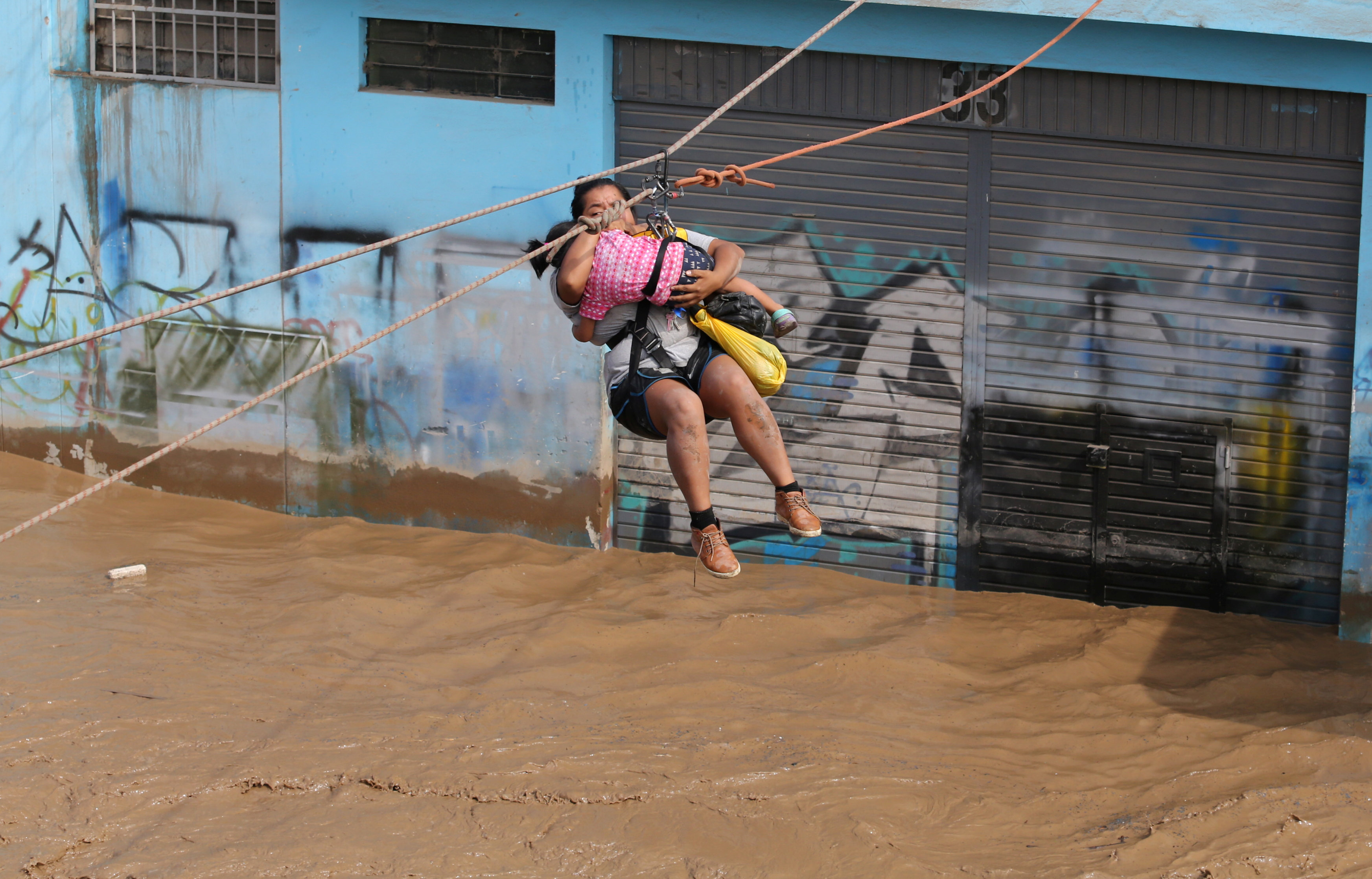
A woman and a child are evacuated with a zip line after the Huayco river overflooded its banks sending torrents of mud and water rushing through the streets in Huachipa, Peru, March 17, 2017. REUTERS/Guadalupe Pardo

A woman and a child are evacuated with a zip line after the Huayco river overflooded its banks sending torrents of mud and water rushing through the streets in Huachipa, Peru, March 17, 2017. REUTERS/Guadalupe Pardo

Peru is bracing itself for another month of flooding.

A local El Nino phenomenon, the warming of surface sea temperatures in the Pacific, will likely continue along Peru’s northern coast at least through April, said Dimitri Gutierrez, a scientist with Peru’s El Nino committee.

Local El Ninos in Peru tend to be followed by the global El Nino phenomenon, which can trigger flooding and droughts in different countries, said Gutierrez.

The U.S. weather agency has put the chances of an El Nino developing in the second half of 2017 at 50-55 percent.

While precipitation in Peru has not exceeded the powerful El Nino of 1998, more rain is falling in shorter periods of time – rapidly filling streets and rivers, said Jorge Chavez, a general tasked with coordinating the government’s response.

“We’ve never seen anything like this before,” said Chavez. “From one moment to the next, sea temperatures rose and winds that keep precipitation from reaching land subsided.”

Some scientists have said climate change will make El Ninos more frequent and intense.

A woman is assisted while crossing a flooded street after the Huayco river overflooded its banks sending torrents of mud and water rushing through the streets in Huachipa, Peru, March 17, 2017. REUTERS/Guadalupe Pardo

A woman is assisted while crossing a flooded street after the Huayco river overflooded its banks sending torrents of mud and water rushing through the streets in Huachipa, Peru, March 17, 2017. REUTERS/Guadalupe Pardo

In Peru, apocalyptic scenes recorded on cellphones and shared on social media have broadened the sense of chaos.

A woman caked in mud pulled herself from under a debris-filled river earlier this week after a mudslide rushed through a valley where she was tending to crops.

Bridges have collapsed as rivers have breached their banks, and cows and pigs have turned up on beaches after being carried away by rivers.

“There’s no need to panic, the government knows what it’s doing,” President Pedro Pablo Kuczynski said in a televised event, urging people to stay clear of rivers.

In Lima, the capital, classes have been suspended and running water has been restricted after treatment systems were clogged – prompting a rush on bottled water that produced shortages at some supermarkets.

The vast majority of people affected by the extreme weather are poor, including many who built makeshift homes on floodplains that had been dry for 20 years, said Chavez.

“There’s no electricity, no drinking water…no transit because streets are flooded,” said Valentin Fernandez, mayor of the town Nuevo Chimbote.

Chavez said Peru must rethink its infrastructure to prepare for the potential “tropicalization” of the northern desert coast, which some climate models have forecast as temperatures rise.

“We need more and better bridges, we need highways and cities with drainage systems,” said Chavez. “We can’t count on nature being predictable.”

(Reporting by Mitra Taj; Additional reporting by Reuters TV; Editing by Leslie Adler)

Thousands still forced from homes by flooding in California tech hub

Vehicles are seen partially submerged in flood water at William Street Park after heavy rains overflowed nearby Coyote Creek in San Jose, California. REUTERS/Stephen Lam

By Alex Dobuzinskis

(Reuters) – The mucky water flooding a section of San Jose in Northern California forced officials on Wednesday to widen the area under mandatory evacuation orders, with about 14,000 people barred from returning to their homes following drenching rains.

San Jose, a hub of high-tech Silicon Valley, suffered major flooding on Tuesday triggering evacuation orders when Coyote Creek overran its banks, swamping the Rock Springs neighborhood. Water at some sites engulfed the entire first floor of residences while in other places it reached waist-high.

Officials said the city of about 1 million residents has not seen a flood approaching this magnitude since 1997.

The gush of water inundating San Jose flowed down from the Anderson Reservoir, which was pushed to overflowing by a rainstorm that pounded Northern California from Sunday to Tuesday, officials said.

The reservoir’s operators have been releasing water at maximum levels since Jan. 9 but it was not enough to avoid a spillover because of recent storms, Rachael Gibson, a spokeswoman for the Santa Clara Valley Water District, said at a news conference.

Trash-strewn floodwaters inundated city blocks in California’s third-largest city, as firefighters in inflatable boats on Tuesday ferried stranded residents to dry ground.

Aside from 14,000 people whom officials said were placed under mandatory evacuation orders, with many taking up residence in emergency shelters, the city has issued a less severe evacuation advisory to 22,000 people, urging them to leave their homes as well.

“This is nothing you ever want to see in your community,” San Jose Mayor Sam Liccardo told a news conference.

Residents of the flooded area, which is near downtown and is made up of apartment buildings and townhomes, would not be allowed to return to their properties on Wednesday, Liccardo said. “We’re not out of this yet,” he said.

The Weather Service forecasts light rain to resume this weekend in the area.

It was not immediately clear how many homes suffered flood damage.

A section of the 101 Freeway in San Jose and another strip of the thoroughfare south of the city were closed by flooding, according to the California Highway Patrol.

Coyote Creek crested at a record-breaking 14.4 feet (4.4 meters) on Tuesday evening, said National Weather Service forecaster Bob Benjamin.

The previous record was in 1922, at 12.8 feet (3.9 meters), Benjamin said.

“Quite possibly we won’t see a return to a flood this weekend because the (weather) system does not look terribly imposing,” Benjamin said.

(Reporting by Alex Dobuzinskis in Los Angeles; Editing by Dan Whitcomb and Sandra Maler)

Flooding forces hundreds from homes in San Jose, California

Rescuers from the San Jose Fire Department pilot boats while evacuating residents of Nordale Avenue after the Coyote Creek flooded parts of San Jose, California, U.S. February 21, 2017. Courtesy of Chris Smead/Csmeadphotography/Handout via REUTERS

By Alex Dobuzinskis

(Reuters) – Murky, waist-high floodwaters swamped neighborhoods along a rain-swollen creek in the northern California city of San Jose on Tuesday, prompting authorities to issue evacuation orders or advisories for more than 1,000 homes, city officials said.

The state’s third-largest city, a hub of the high-tech Silicon Valley corridor south of San Francisco, has about 1 million residents and declared an emergency as Coyote Creek overflowed its banks from days of heavy showers.

The trash-strewn floodwaters inundated whole city blocks, submerging parked cars and lapping at the walls of apartments and townhouses, as firefighters in inflatable boats ferried stranded residents to dry ground.

About 300 homes were ordered evacuated in low-lying Rock Springs, and city officials urged residents of roughly 200 dwellings in the Williams Street neighborhood downstream to leave their homes, city spokesman David Vossbrink said.

After dark, fire department crews began going door to door advising residents of three creek-side mobile home parks, consisting of about 600 trailers, to move to higher ground, Vossbrink said, adding that the stream was continuing to rise.

At a news conference earlier in the day, Mayor Sam Liccardo acknowledged that municipal officials should have moved more quickly in evacuating the Rock Springs area.

“As I sit here today and I look out at a neighborhood that’s completely inundated with water … there’s no question in my mind there was a failure of some kind,” he said.

City officials had no reports of injuries, deaths or people missing, said Vossbrink, who estimated at least 300 homes were damaged by flooding.

The San Jose Fire Department advised a decontamination cleansing for those immersed in floodwaters to get rid of hazardous pollutants.

The latest series of downpours that swept northern California on Sunday and Monday weakened on Tuesday, the National Weather Service said. Meteorologists said the storms were spawned by an “atmospheric river” bringing moisture from the Pacific Ocean.

Last week a string of storms triggered a crisis near the Lake Oroville Dam about 100 miles (160 km) northeast of San Francisco, where damage to two spillways prompted an evacuation of more than 100,000 people downstream.

California is slowly recovering from five years of drought thanks to several months of unusually wet weather.

At least 3 inches (8 cm) of rain fell in many areas, though some received far more, such as the sparsely populated Big Sur region and outside the city of Santa Rosa, which got more than 8 inches (20 cm), the weather officials said.

The next heavy storm is expected to hit Northern California this weekend, they added.

(Reporting by Alex Dobuzinskis in Los Angeles; Additional reporting and Writing by Steve Gorman in Los Angeles; Editing by James Dalgleish and Clarence Fernandez)

Tornadoes pummel San Antonio, many homes and businesses damaged

Monday evening radar, storms trek East

by Kami Klein

Severe Storms, downpours and tornadoes hit the residential areas north and northeast of downtown San Antonio shortly after midnight and early morning Monday.  The National Weather Service confirmed Monday morning that four tornadoes hit San Antonio. Two were rated EF-1, with winds of 110 and 105 mph. The third and fourth were rated an EF-0, with winds of 70 and 85 mph.

USA Today reported over 150 homes and businesses received damage from these tornadoes that ripped through the area.  Five injuries were reported by city officials, but all were minor.  At the height of the outages, CPS Energy reported nearly 40,000 customers without power due to the storms.

Storms continued to pound the state of Texas as the storm system moved on towards the east.  The National Weather Service is predicting more severe thunderstorms heading towards eastern Texas and Louisiana late Monday and headed towards the evening hours.  The National Weather Service is predicting more flooding and high winds in these potentially dangerous systems.


California faces more rain, snow as deadly storm moves south

People with umbrellas walk along street in Los Angeles

(Reuters) – California was bracing on Saturday for another wave of torrential rain as well as heavy snow as a massive storm triggered flooding, mudslides and power outages and killed two people, officials said.

The National Weather Service warned that rain totals could reach 10 inches (25 cm) in parts of southern California and 2 feet (60 cm) of snow in higher areas to the east as the storm continues to roll through the region.

The severe storm has brought California its heaviest rainfall in six years and comes after months of wet weather that has dramatically eased a years-long drought in the key agricultural state.

The rain and melting snowpack also are threatening to undermine a spillway at one of the largest dams in the country. Some 188,000 residents were evacuated from the area earlier this week.

Utility crews were working to restore electricity to more than 78,000 customers affected by power outages throughout the Los Angeles area.

Early on Saturday, an evacuation order remained in effect for 180 homes in Duarte, a city about 20 miles (32 km) east of Los Angeles, because of fears of mudslides.

One man died after he was electrocuted by a downed wire, the Los Angeles Fire Department said, adding that it had responded to 150 reports of downed wires on Friday. Another person was found dead in a submerged vehicle in Victorville, about 100 miles east of Los Angeles, fire officials said on Twitter.

A woman was injured when the car she was in fell into a 20-foot sinkhole in Studio City on Friday night. A second car fell into the sinkhole after the woman was rescued, an ABC affiliate reported.

Local television news also showed video footage of a San Bernardino County fire truck tumbling over the side of a freeway as the road gave out.

“All firefighters confirmed safe. The lane under the fire engine has failed, and the engine has gone over the side,” the San Bernardino County Fire Department said on Twitter.

Amtrak railroad service was suspended for trains between the cities of Oxnard and San Luis Obispo in the central and southern areas of the state due to extreme weather conditions, according to the transportation service’s website.

In higher areas of eastern California and western Nevada, snowfall and wind gusts of up to 50 mph (80 kph) were in the forecast until Saturday night, the National Weather Service said.

“This will make travel hazardous or impossible,” the service said in an advisory.

(Reporting by Brendan O’Brien in Milwaukee Editing by Ed Osmond and Paul Simao)

Evacuees from California dam allowed home even as storms near

Oroville residents look at flooded area after evacuation order

By Deborah M. Todd

OROVILLE, Calif. (Reuters) – Californians who were ordered to evacuate due to a threat from the tallest dam in the United States can now return home after state crews working around the clock reinforced a drainage channel that was weakened by heavy rain.

Officials had ordered 188,000 people living down river from the Oroville Dam to evacuate on Sunday and reduced that to an evacuation warning on Tuesday, Butte County Sheriff Kory Honea said.

That means people can move back to their homes and businesses can reopen, but they should be prepared to evacuate again if necessary, Honea told a news conference.

Both the primary and backup drainage channels of the dam, known as spillways, were damaged by a buildup of water that resulted from an extraordinarily wet winter in Northern California that followed years of severe drought.

The greater danger was posed by the emergency spillway, which was subject to urgent repairs in recent days. Though damaged, the primary spillway was still useable, officials said.

More rain was forecast for as early as Wednesday and through Sunday, according to the National Weather Service, but the state Department of Water Resources said the upcoming storms were unlikely to threaten the emergency spillway.

Evacuees received more good news from President Donald Trump, who declared an emergency in the state, authorizing the Federal Emergency Management Agency and the Department of Homeland Security to coordinate disaster relief efforts.

The lifting of the mandatory evacuation improved the mood among evacuees at Silver Dollar Fairgrounds in Chico, where families packed cars and sifted through piles of donated clothing.

Philip Haar, 37, of Oroville, prepared to take his five dogs back home. He also would be able to feed the rabbit he left behind.

“I’m confident with the warning, at least we’ll know the next time something happens to be prepared more than this time,” Haar said.

But Richard and Anna Lawson of Oroville said they were not rushing home. Officials last week expressed calm, then abruptly ordered the evacuation on Sunday.

“They kept contradicting themselves. Every time they said something they turned around and said something different,” said Richard, 25.

“We’re waiting until tomorrow to hear something. We’re going to wait until the storm comes through,” said Anna, 21.

The sheriff credited swift action by the Department of Water Resources to shore up the emergency spillway and use the main spillway to relieve pressure on the dam, averting the immediate danger of a dam failure, Honea said.

A failure could have unleashed a wall of water three stories tall on towns below.

State officials used 40 trucks carrying 30 tons of rock per hour to reinforce the eroded area around the emergency spillway while two helicopters dropped rock and other materials into the breach.

“We’re aggressively attacking the erosion concerns that have been identified,” said William Croyle, acting director of the Department of Water Resources.

Water authorities had been relieving pressure on the dam through the concrete-lined primary spillway last week, but lake levels rose as storm water surged in and engineers moderated its use. Then the rising water topped over the earthen backup spillway, which has a concrete top, for the first time in the dam’s 50-year history over the weekend.

When the emergency spillway showed signs of erosion, engineers feared a 30-foot-high section could fail, leading to the evacuation order on Sunday. Both spillways are next to the dam, which itself is sound, engineers say.

(Additional reporting by Gina Cherelus and Sharon Bernstein; Writing by Daniel Trotta; Editing by Peter Henderson, James Dalgleish and Lisa Shumaker)

U.N. warns of catastrophic dam failure in Syria battle

Euphrates River at sunset in Syria

By Tom Miles

GENEVA (Reuters) – The United Nations is warning of catastrophic flooding in Syria from the Tabqa dam, which is at risk from high water levels, deliberate sabotage by Islamic State (IS) and further damage from air strikes by the U.S.-led coalition.

The earth-filled dam holds back the Euphrates River 40 km (25 miles) upstream of the IS stronghold of Raqqa and has been controlled by IS since 2014.

Water levels on the river have risen by about 10 meters since Jan. 24, due partly to heavy rainfall and snow and partly to IS opening three turbines of the dam, flooding riverside areas downstream, according to a U.N. report seen by Reuters on Wednesday.

“As per local experts, any further rise of the water level would submerge huge swathes of agricultural land along the river and could potentially damage the Tabqa Dam, which would have catastrophic humanitarian implications in all areas downstream,” it said.

The entrance to the dam was already damaged by airstrikes by the U.S.-led coalition, it said.

“For example, on 16 January 2017, airstrikes on the western countryside of Ar-Raqqa impacted the entrance of the Euphrates Dam, which, if further damaged, could lead to massive scale flooding across Ar-Raqqa and as far away as Deir-ez-Zor.”

The town of Deir-ez-Zor, or Deir al-Zor, is a further 140 km downstream from Raqqa, and is besieged by IS. The U.N. estimates that 93,500 civilians are trapped in the town, and it has been airdropping food to them for a year.

The U.S.-backed Syrian Democratic Forces (SDF) are undertaking a multiphased operation to encircle Raqqa, and have advanced to within a few kilometers of the dam. The SDF has previously said air strikes are not being used against IS near the dam to avoid damaging it.

As IS, also known as ISIL, retreats, its fighters have deliberately destroyed vital infrastructure, including three water stations and five water towers in the first three weeks of January, the U.N. report said.

“ISIL has reportedly mined water pumping stations on the Euphrates River which hinders the pumping of water and residents are resorting to untreated water from the Euphrates River.”

The U.N. has also warned of the danger of a collapse of the Mosul dam on the Tigris River in Iraq, which could affect 20 million people. The dam was briefly captured by IS in 2014, but remains at risk, with constant repairs needed to avoid disaster.

Last month Lise Grande, the top U.N. humanitarian official in Iraq and a trained hydrologist who is an expert on the Mosul dam, said a catastrophic burst could have “Biblical” consequences. The U.N. is preparing an international response in case the Mosul dam collapses.

(Reporting by Tom Miles; Editing by Toby Chopra)

No return home in sight for thousands of Californians sheltering from dam

Oroville Dam flooding in Calfornia

By Deborah M. Todd and Sharon Bernstein

OROVILLE, Calif. (Reuters) – Tens of thousands of Californians faced an indefinite stay in shelters as engineers worked for a second day on Tuesday to fix the United States’ tallest dam before more storms sweep the region.

After what looks set to be the wettest winter in Northern California following years of drought, more rain was forecast for as early as Wednesday and through Sunday, according to the National Weather Service.

Crews were working to shore up an overflow channel and drain the reservoir at the Lake Oroville Dam but authorities gave no indication of when it would be safe for people to go home.

Late on Sunday, about 188,000 residents were ordered to evacuate their homes in the Feather River valley below the dam, 65 miles (105 km) north of Sacramento.

Authorities say they had averted the immediate danger of a catastrophic failure at the dam that could unleash a wall of water three stories tall on towns below.

“We’re doing everything we can to get this dam in shape that they can return and they can live safely without fear. It’s very difficult,” California Governor Jerry Brown told reporters during a news conference on Monday evening.

On Monday, Brown sent a letter to U.S. President Donald Trump asking him to issue an emergency declaration, which would open up federal assistance for the affected communities, after an emergency overflow channel appeared on the brink of collapse.

Yolanda Davila, 62, of Thermalito, ended up at the Silver Dollar Fairgrounds in Chico, one of only five in the area taking people with pets. She left home without medicine and dog food in the rush to find shelter before the evacuation deadline.

She said that areas such as Sacramento had been issued flood warnings earlier in the week and that authorities should have warned residents near Oroville much sooner.

“We didn’t have a plan, all we knew is to head north toward Chico,” Davila said. “If I knew we had to get out earlier I would have went to the Bay Area.”

The earth-filled dam is just upstream and east of Oroville, a town of about 16,000 people. At 770 feet (230 meters) high, the structure, built between 1962 and 1968, it is more than 40 feet taller than the Hoover Dam.

On Monday afternoon, crews dropped large bags filled with rocks into a gap at the top of the emergency spillway to rebuild the eroded hillside.

The main spillway, a separate channel, is also damaged because part of its concrete lining fell apart last week. Both spillways are to the side of the dam itself, which has not been compromised, engineers said.

(Additional reporting by Brendan O’Brien in Milwaukee; Editing by Louise Ireland)

Spillway on California dam in danger of collapse, evacuations ordered

65,000 cfs of water flow through a damaged spillway on the Oroville Dam in Oroville, California, U.S.

By Dan Whitcomb

(Reuters) – Residents below the tallest dam in the United States, near Oroville in Northern California, were urgently ordered to evacuate on Sunday as a spillway appeared in danger of imminent collapse.

The abrupt evacuation orders came as authorities determined that the auxiliary spillway on the Lake Oroville Dam could give way at any time, unleashing floodwaters onto rural communities along the Feather River. “Immediate evacuation from the low levels of Oroville and areas downstream is ordered,” the Butte County sheriff said in a statement posted on social media. “This is NOT A Drill.”

The Oroville dam is nearly full after weeks of heavy rains and snow brought relief to the state after some four years of devastating drought.

The California Department of Water Resources said on Twitter at about 4:30 p.m. PST that the spillway next to the dam was “predicted to fail within the next hour.”

However it was still standing nearly three hours later as the Water Resources department said crews would use helicopters to drop rocks to fill a gouge in the spillway. Authorities were also releasing water to lower the lake’s level.

The Yuba County Office of Emergency Services urged evacuees to travel only to the east, south or west. “DO NOT TRAVEL NORTH TOWARD OROVILLE,” the department said on Twitter.

Evacuation centers were set up at a fairgrounds in Chico, California, about 20 miles northwest of Oroville, but roads leading out of the area were jammed as residents sought to drive out of the flood zone.

It was not clear how many residents were affected by the evacuation order.

State authorities and engineers on Thursday began carefully releasing water from the Lake Oroville Dam some 65 miles (105 km) north of Sacramento after noticing that large chunks of concrete were missing from a spillway.

Water levels were less than 7 feet (2 meters) from the top of the dam on Friday.

California Governor Jerry Brown asked the Federal Emergency Management Agency on Friday to declare a major disaster due to flooding and mudslides brought on by the storms.

The earthfill dam is just upstream and east of Oroville, a city of more than 16,000 people.

At 770 feet (230 meters) high, the structure, built between 1962 and 1968, is the tallest dam in the United States, besting the famed Hoover Dam by more than 40 feet (12 meters).

(Reporting by Dan Whitcomb in Los Angeles; Editing by Peter Cooney and Mary Milliken)

Bangladesh resurrects plan to move Rohingya refugees to flooded island

refugees walk to flooded island

By Ruma Paul

DHAKA (Reuters) – Bangladesh has resurrected a plan to relocate thousands of Rohingya Muslims fleeing violence in Myanmar’s northwestern Rakhine State to a flooded island in the Bay of Bengal to prevent them from “intermingling” with Bangladeshi citizens.

The United Nations says around 69,000 people have fled the Muslim-majority northern part of Rakhine to Bangladesh since attacks that killed nine Myanmar border police on Oct. 9, sparking a heavy-handed security response in which scores were killed.

Bangladesh first proposed the idea of sending the Rohingya to Thengar Char, which floods at high tide, in 2015, prompting anger among rights groups.

In a Jan. 26 notice on its website, Bangladesh’s cabinet said several panels were set up to examine the influx of Rohingya Muslims, which the country fears could lead to law and order issues as they mix with residents.

Dhaka was preparing a list of the people to be temporarily moved to Thengar Char before being sent back to Myanmar, it said.

“There’s a fear that the influx of Rohingya Muslims from time to time will lead to a degradation of law and order situation, spread communicable diseases … and create various social and financial problems,” it added.

A Bangladesh home ministry official said the process to shift the Rohingya to the island would take time, adding, “If that place is not livable, the government will make it livable.”

International aid officials working with the refugees, now sheltered in the tourist resort of Cox’s Bazar, said they were surprised by the relocation plan and had sought clarification from the Bangladesh government. However, they declined to be identified, citing the sensitivity of the situation.

RELIGIOUS TENSION

Hundreds were killed in communal clashes in Rakhine in 2012, exposing a lack of oversight of the military by the administration of Nobel Peace Prize winner Aung San Suu Kyi.

Many Myanmar Buddhists view the Rohingya as illegal immigrants from Bangladesh, but an advisory panel of the Myanmar government said the refugee crisis was more than just a religious issue.

Three members of the Advisory Commission on Rakhine State visited the refugees in Cox’s Bazar on Monday. They met government officials in the capital, Dhaka, on Tuesday.

“There are many Muslims outside Rakhine … they are Myanmar citizens,” one member, Ghassan Salame, told reporters on Tuesday. “There’s a religious dimension to the conflict, but there are also the issues of rights, citizenship, ethnicities, issues related to freedom of movement and the rule of law and human rights.”

(Reporting by Ruma Paul; Additional reporting by Serajul Quadir and Antoni Slodkowski; Writing by Krishna N. Das; Editing by Nick Macfie and Clarence Fernandez)