Montana officials warn water supply would run out in 36 hours

Revelation 16:9 “They were scorched by the fierce heat, and they cursed the name of God who had power over these plagues. They did not repent and give him glory.”

Important Takeaways:

  • Residents of Montana’s largest city are warned water supply could run out in 36 HOURS after the only local treatment plant was inundated by devastating floods that have also closed Yellowstone National Park ‘indefinitely’ for first time in decades
  • Billings has just a 24-to 36-hour supply of water and officials asked its 110,000 residents to conserve
  • Officials did express optimism that the river would drop quickly enough for the plant to resume operations before the supply ran out
  • Heavy weekend rains and melting mountain snow had the Yellowstone River flowing at a historically high level of 16 feet as it raced past Billings
  • The city gets its water from the river and was forced to shut down its treatment plant at about 9:30 a.m. because it can’t operate effectively
  • ‘None of us planned a 500-year flood event on the Yellowstone when we designed these facilities,’ said Debi Meling, the city’s public works director

Read the original article by clicking here.

Drought Costing California Thousands of Jobs and Big Money

Important Takeaways:

  • Drought cost California’s ag industry $1.1 billion last year, UC Merced researchers say
  • The report also states once the effects on other economic sectors are considered, total impacts are estimated at $1.7 billion and 14,634 full- and part-time jobs lost.
  • Other drought-affected areas include the Russian River Basin and intermountain agricultural areas in Siskiyou, Shasta and Modoc counties.
  • The crops most significantly affected by increased fallowing include rice in the Sacramento Valley, cotton in the San Joaquin Valley, and grain and field crops statewide, the release said.
  • While Californians are familiar with drought, the 2020-21 water years were the second driest two years on record. Although precipitation deficits were widespread, drought conditions were more severe in the Sacramento Valley and the North Coast regions.
  • But drought is not only defined by the water supply, the researchers wrote. Warmer temperatures and already-dry conditions increased crop irrigation demands and widened the gap between water supply and irrigation needs.

Read the original article by clicking here.

91% of Portugal hit with severe or extreme drought

Important Takeaways:

  • Portugal drought worsens, raising fears for crops and water supply
  • A severe drought spread across almost all of mainland Portugal in February, threatening crops and water supplies across a wider area than during the last record dry spell in 2005
  • The area of mainland Portugal suffering severe or extreme drought doubled in the first two weeks of February to cover 91% of its territory, the IPMA said (the meteorology agency)
  • Earlier this month, the Portuguese government ordered some hydropower dams to temporarily limit water use for electricity production and irrigation, prioritizing human consumption instead.
  • Environment Minister Joao Pedro Matos Fernandes said at the time the government would have to “go beyond these measures if the forecast became gloomier.”

Read the original article by clicking here.

More than 1.3 million Texans still grappling with water supply disruptions

By Kanishka Singh

(Reuters) – More than 1.3 million people across over 200 counties in Texas still had issues with their water supply by Wednesday, but that was down sharply from recent days, a spokesman for the Texas Commission on Environmental Quality (TCEQ) said.

That figure compared with Tuesday’s 3.4 million, Monday’s 8 million and Sunday’s 9 million, or about a third of the state’s population.

A deadly winter storm caused widespread blackouts last week across Texas, a state unaccustomed to extreme cold, killing at least two dozen people and knocking out power to more than 4 million at its peak.

As of Wednesday evening, “33 Public Water Systems are non-operational, affecting 20,689 Texans,” the spokesman told Reuters in an emailed statement, adding that 204 counties were reporting issues with their public water systems (PWS).

He said around 853 PWSs were on a boil water notice, meaning people were being advised to boil water before consuming it, affecting 1,333,134 Texans. Some 1,176 previously issued boil water notices had been rescinded, he added.

Once the current crisis is over, TCEQ plans to examine the ongoing experience to prevent such a disruption from taking place in the future, TCEQ Executive Director Toby Baker told Reuters on Wednesday.

Texas Governor Greg Abbott pledged on Wednesday to overhaul the state’s electric grid operator after a massive blackout left residents without heat, power or water for days.

The Electric Reliability Council of Texas (ERCOT), which manages the flow of power to about 90% of state residents, has faced sharp criticism over its failure to prepare for severe cold. Outages caused billions of dollars of damages to homes and businesses.

Six ERCOT directors have resigned and a board nominee declined a seat in the wake of sharp criticism of the group’s performance.

(Reporting by Kanishka Singh in Bengaluru; Editing by Tom Hogue and Ana Nicolaci da Costa)

Millions stranded in India as early monsoon downpours bring flood havoc

A woman displaced by the recent flood sleeps inside a classroom of Shree Sarsawati Higher Secondary School at Bhalohiya village in Rautahat, Nepal, July 17, 2019. REUTERS/Riwaj Rai

By Zarir Hussain

GUWAHATI, INDIA (Reuters) – Millions of people are stranded by flooding in northeast India with concern growing about food and water supplies even though the impact of heavy, early monsoon rain appeared to be easing, the government said on Wednesday.

More than 4.7 million people have been displaced in the tea-growing state of Assam, with many thousands making do with only the most meagre food supplies and dirty water.

“We’ve just been surviving on boiled rice for almost seven days now,” said Anamika Das, a mother at Amtola relief camp in Assam’s Lakhimpur district.

She said she was having difficulty breastfeeding her baby boy.

A man uses a makeshift raft to move his paddy to a safer place in a flooded area in Morigaon district in the northeastern state of Assam, India, July 16, 2019. REUTERS/Anuwar Hazarika

A man uses a makeshift raft to move his paddy to a safer place in a flooded area in Morigaon district in the northeastern state of Assam, India, July 16, 2019. REUTERS/Anuwar Hazarika

Assam has been the worst-affected part of India. Floods have also hit neighboring Nepal and Bangladesh.

At least 153 people have been killed in India, Nepal and Bangladesh. Parts of Pakistan have also seen flooding.

Subhas Bania, also sheltering at Amtola, said authorities had made no provision for the supply of drinking water.

“We’ve been forced to drink muddy water,” he said.

The rains in north India usually last from early June to October, with the worst of the flooding usually later in the season.

Assam is frequently swamped by floods when the Brahmaputra river, which flows down from the Himalayas through northeast India and Bangladesh, sweeps over its banks.

Water levels on the river and its major tributaries were beginning to fall, although they were still above the danger mark, the government said.

“We’re trying our best to reach out to the affected people in whatever way possible but yes, the situation is indeed very bad,” said Assam’s Social Welfare Minister Pramila Rani Brahma.

The government has yet to assess the impact of the floods that have battered thousands of settlements.

Bhabani Das, a village elder in Golaghat district, who has been living under a plastic sheet for four days, said the flood had swept away her home.

“Where do we go from here?”

In the state of Bihar, which has also been hit by severe flooding, beginning last week, officials said that floodwaters were beginning to recede after killing 33 people.

“Things are gradually becoming normal, people are returning home,” Bihar’s Disaster Management Minister Lakshmeshwar Roy said.

Water levels in four rivers in Bangladesh, including the Brahmaputra, were above the danger mark, with some northern parts of the low-lying country flooded.

Road and railway links between the capital city of Dhaka and at least 16 northern and northwest districts had been severed, officials said.

(Reporting Zarir Hussain in GUWAHATI, Jatindra Dash in BHUBANESWAR, Serajul Quadir in DHAKA; Writing by Devjyot Ghoshal; Editing by Sanjeev Miglani, Robert Birsel)

‘We have nothing to survive on;’ desperation as Haiti toll hits over 400

People try to rebuild their destroyed houses after Hurricane Matthew passes Jeremie, Hait

By Makini Brice and Joseph Guyler Delva

LES CAYES, Haiti/PORT-AU-PRINCE (Reuters) – The number of people killed by Hurricane Matthew in Haiti rose rapidly into the hundreds on Thursday, mainly in villages making contact with the outside world days after the cyclone ripped through the impoverished nation’s picturesque western peninsula.

With the numbers rising quickly, different government agencies and committees differed on the total death toll. A Reuters tally of deaths reported by civil protection officials at a local level showed the storm killed at least over 400 people.

“Several dozen” were killed in the coastal town of Les Anglais in Sud Department, said Louis Paul Raphael, the central government’s representative in the region. Inland in nearby Chantal, the toll rose to 90 late in the evening, the town’s  mayor said.
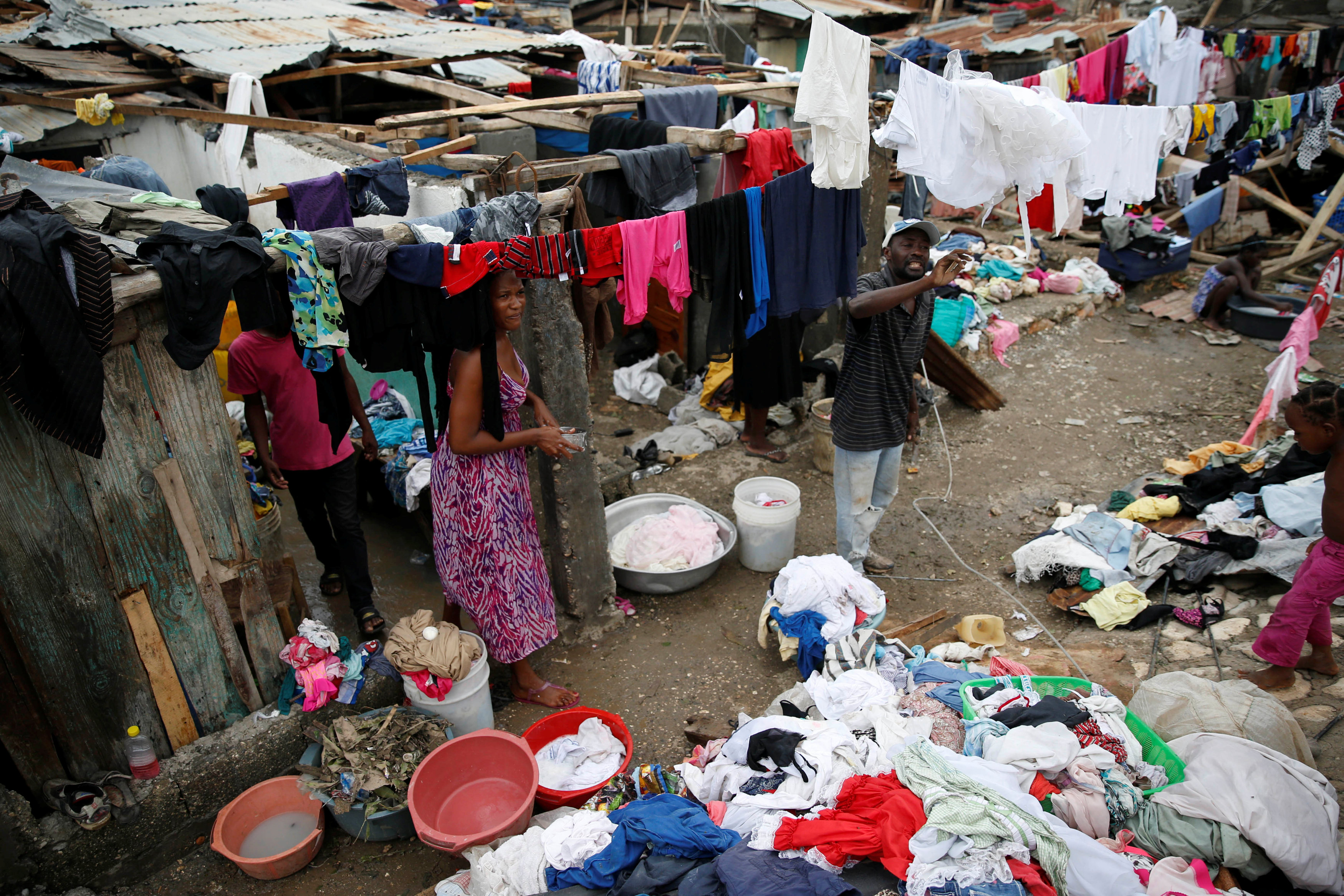
People wash their clothes in front of their partially destroyed houses after Hurricane Matthew passes

People wash their clothes in front of their partially destroyed houses after Hurricane Matthew passes Jeremie, Haiti, October 6, 2016. REUTERS/Carlos Garcia Rawlins

In 2010, a magnitude 7 earthquake wrecked Port-au-Prince, killing upward of 200,000 people. However, the impact of this tragedy, has been felt most in a remote but populated region, far from the capital’s support.

“We have nothing left to survive on, all the crops have gone, all fruit trees are down, I don’t have a clue how this is going to be fixed,” said Marc Soniel Noel, the deputy mayor of Chantal.

Matthew is the strongest hurricane in the Caribbean since Felix in 2007 and was closing in on Florida as a Category 4 cyclone, the second strongest on the Saffir–Simpson hurricane wind scale. Four people were killed over the weekend in the Dominican Republic, which shares the island of Hispaniola with Haiti.

The devastation in Haiti prompted authorities to postpone a presidential election scheduled for Sunday.

Many victims were killed by falling trees, flying debris and swollen rivers when Matthew hit on Tuesday with winds of 145 miles per hour (230 kph).

Most of the fatalities were in towns and fishing villages around the western end of Tiburon peninsula in Haiti’s southwest, a region of white Caribbean beaches and rivers backed by hills.

The storm passed directly through the peninsula, driving the sea inland and flattening homes on Monday and Tuesday.

People gather next to a collapsed bridge after Hurricane Matthew passes Petit Goave, Hait

People gather next to a collapsed bridge after Hurricane Matthew passes Petit Goave, Haiti, October 5, 2016. REUTERS/Carlos Garcia Rawlins

FLEEING IN PANIC

Les Anglais was the first to be hit by Matthew and has since been out of contact. The mayor told Reuters just before the storm hit that people were fleeing their houses in panic as the sea surged into town.

A few miles south in Port-a-Piment village, Mayor Jean-Raymond Pierre-Louis said 25 people were killed. Another 24 were killed in the village of Roche-a-Bateau further south.

In Grand Anse Department, also on the storm’s destructive path but on the other side of the peninsula, 38 more lost their lives.

Earlier on Thursday, a meeting of emergency workers including representatives from the government, the United Nations and international aid agencies said 283 had been killed. Reuters attended the meeting.

In one public hospital in Les Cayes, a coffee and vetiver exporting port on Haiti’s Tiburon peninsula, most doctors had not shown up to work since they took shelter as the storm hit. Food and water were scarce in shelters.

Poverty, weak government and precarious living conditions for many of its citizens make Haiti particularly vulnerable to natural disasters. International aid has at times made things worse.

Following the 2010 earthquake, U.N. peacekeepers inadvertently introduced cholera to Haiti, killing at least 9,000 people and infecting hundreds of thousands more.

The Pan American Health Organization said on Thursday it was preparing for a possible cholera surge in Haiti after the hurricane because flooding was likely to contaminate water supplies.

In Les Cayes’ tiny airport, windows were blown out and the terminal roof was mostly missing, although the landing strip was not heavily damaged.

“The runway is working. In the hours and days to come, we can receive humanitarian flights,” said Sergot Tilis, the information officer and runway agent for the airport.

(Reporting by Makini Brice and Joseph Guyler Delva; Writing by Frank Jack Daniel; Editing by Paul Tait)

Volcanic Eruptions Reduce Flow of Major Rivers

Scientists have found that volcanic eruptions affect the flow of the world’s major rivers.

New research from the University of Edinburgh shows that aerosol particles ejected into the air following volcanic eruptions don’t just contaminate the atmosphere, they can often trigger rainfall shortages that ultimately affect river systems worldwide.

In the first study of its kind, University of Edinburgh scientists Carley Iles and Gabriele Hegerl compared annual water flow in 50 rivers around the world with the timing of major volcanic eruptions, notably Agug in 1963, El Chichon in 1982 and Pinatubo in 1991.

For some rivers, records went back into the 19th century, making it possible to take into account earlier eruptions too.

They discovered that a year or two after these volcanoes hurled massive amounts of debris into the upper atmosphere they created a partial sunscreen and the flows of tropical rivers decreased.

On the contrary, river flow increased in some regions, including the U.S. southwest and parts of South America. Researchers linked this to the disruption of atmospheric circulation patterns.

Dr. Carley Iles, from the School of GeoSciences at the University of Edinburgh, said in a statement. “Our findings reveal the indirect effect that volcanoes can have on rivers, and could be very valuable in the event of a major volcanic eruption in future,”

The study, published in Nature Geoscience, cautioned against so-called geo-engineering schemes that have been proposed as an answer for cooling down an overheated planet or global warming.

“As well as affecting river flow and rainfall, volcanic eruptions have a cooling effect on climate,” Dr Iles said.

“All of these impacts come about because volcanoes inject particles — sulfate aerosols — high up into the atmosphere, and these spread out and reflect sunlight back out into space.”

Drought Could Cut Water To Brazil’s Largest City

A drought that has been called the “worst to hit Brazil’s biggest city in decades” is threatening to collapse the city’s water system.

Sao Paulo water utility company Sabesp says that unless they move now to a five days off, two days on system for providing water, the Cantareia water system will collapse.

Sao Paulo is Brazil’s richest state and economic hub.  Officials are concerned the lack of water will have a significant negative impact on the region’s and the nation’s economy as businesses will begin to relocate to other areas and countries.

The biggest impact would be on industrial factories that rely on large scale water supplies to produce goods.

The utility says the Cantareria is at 5.1% of capacity of 264 billion gallons due to the drought.

The state has been attempting to rush projects to bring extra water into the Cantareia system but the projects are well behind schedule.

Earthquake Could Cut Off L.A.’s Water Supply

Los Angeles is one earthquake away from losing a major part of their water supply.

The city of Los Angeles gets almost 90 percent of its water from three major aqueducts.  These aqueducts run from the Colorado River, Owens Valley and the Sacramento-San Joaquin River Delta.

The aqueducts cross the well-known San Andreas Fault a total of 32 times.

This means any major quake along that fault line could end the water supply into the nation’s second largest city.

Mayor Eric Garcetti is calling on city officials to create better plans to protect the city’s water supply.

“[Water is] one of L.A.’s greatest earthquake vulnerabilities,” Garcetti told the L.A. Times. “If it were to take six months to get our water system back … residents and businesses would be forced to relocate for so long that they might never come back.”

Officials are looking to San Francisco’s Public Utilities Commission for a possible solution.  The SFPUC recently installed a specially designed pipe over a fault line that has “accordion-like joints” that would allow the pipe to flex and move in any direction should the fault line move.

“We’re the first city that’s really bet its life on outside water,” U.S. Geological Survey seismologist Lucy Jones told the Times. “We have to cross the faults. There’s no way to not go over the fault.”

“There should be a serious dialogue among the agencies that are responsible for the three sources of water to Southern California,” said Thomas O’Rourke, a Cornell University engineering professor. “Sometimes it’s very difficult to go beyond those institutional barriers…. Somebody just has to take it up.”