U.S. Southeast, Midwest face threat of severe storms, potential tornadoes

Stock photo of a thunderstorm that could produce tornadoes. Courtesy of Pixabay

(Reuters) – A dangerous weather system packing severe thunderstorms was expected to roll through the U.S. Southeast and parts of the Midwest on Wednesday, bringing with it the threat of tornadoes, forecasters said.

The region faced the threat of supercells developing throughout the day as very large hail and damaging straight-line wind appear to be likely, the National Weather Service said in an advisory.

At about 5:30 a.m. local time, a thunderstorm was moving northeast of Anniston, Alabama, at 55 miles (89 km) per hour, bringing with it hail the size of golf balls and 60 mile (98 km) per hour wind gusts, the Weather Service reported.

“For your protection move to an interior room on the lowest floor of a building,” the National Weather Service warned in an advisory.

Kentucky, Tennessee, Alabama, Georgia and South Carolina faced a heightened chance of tornadoes and potential flash flooding during the day.

The 5.7 million people who live in the Atlanta metro area should expect as much as 2-1/2 inches (6 cm) of rain throughout the day and into the evening, the service said.

Dozens of school districts in Alabama and Georgia canceled classes while Alabama Governor Robert Bentley issued a state of emergency ahead of the storm front.

“Alabama is no stranger to the impact severe weather can have on communities and the devastation that can occur when the weather takes a turn for the worse,” Bentley said in a statement.

The severe weather comes days after a powerful storm system in the southeastern U.S. killed four people, including a woman who was swept away by flood waters while she called 911.

(Reporting by Brendan O’Brien; Editing by Chizu Nomiyama)

Colombia starts to bury 273 landslide victims, search continues

New coffins for reburials, are seen in a cemetery after flooding and mudslides caused by heavy rains leading several rivers to overflow, pushing sediment and rocks into buildings and roads, in Mocoa, Colombia April 3, 2017. REUTERS/Jaime Saldarriaga

MOCOA, Colombia (Reuters) – Scores of decomposing cadavers were being released for burial on Monday as rescuers continued to search for victims of weekend flooding and landslides that devastated a city in southern Colombia, killing at least 273 people.

Desperate families queued for blocks in the heat to search a morgue for loved ones who died when several rivers burst their banks in the early hours of Saturday, sending water, mud and debris crashing down streets and into houses as people slept.

Bodies wrapped in white sheets lay on the concrete floor of the morgue as officials sought to bury them as soon as possible to avoid the spread of disease. The government has begun vaccination against infection.

“Please speed up delivery of the bodies because they are decomposing,” said Yadira Andrea Munoz, a 45-year-old housewife who expected to receive the remains of two relatives who died in the tragedy.

But officials asked for families to be patient.

“We don’t want bodies to be delivered wrongly,” said Carlos Eduardo Valdes, head of the forensic science institute.

The death toll has ticked up during the day as rescuers searched with dogs and machinery in the mud-choked rubble.

Aerial view of a neighborhood destroyed after flooding and mudslides caused by heavy rains leading several rivers to overflow, pushing sediment and rocks into buildings and roads, in Mocoa, Colombia April 3, 2017. REUTERS/Jaime Saldarriaga

Aerial view of a neighborhood destroyed after flooding and mudslides caused by heavy rains leading several rivers to overflow, pushing sediment and rocks into buildings and roads, in Mocoa, Colombia April 3, 2017. REUTERS/Jaime Saldarriaga

Many families in Mocoa have spent days and nights digging through the debris with their hands despite a lack of food, clean water and electricity.

President Juan Manuel Santos, who made a third visit to the area on Monday, blamed climate change for the disaster, saying Mocoa had received one-third of its usual monthly rain in just one night, causing the rivers to burst their banks.

Others said deforestation in surrounding mountains meant there were few trees to prevent water washing down bare slopes.

More than 500 people were staying in emergency housing and social services had helped 10 lost children find their parents. As many as 43 children were killed.

Families of the dead will receive about $6,400 in aid and the government will cover hospital and funeral costs.

Even in a country where heavy rains, a mountainous landscape and informal construction combine to make landslides a common occurrence, the scale of the Mocoa disaster was daunting compared with recent tragedies, including a 2015 landslide that killed nearly 100 people.

Colombia’s deadliest landslide, the 1985 Armero disaster, killed more than 20,000 people.

Santos urged Colombians to take precautions against flooding and continued rains.

Flooding in Peru last month killed more than 100 people and destroyed infrastructure.

(Reporting by Andres Rojas, Helen Murphy Luis Jaime Acosta and Jaime Saldarriaga; Editing by James Dalgleish and Lisa Shumaker)

Four dead, about 200,000 without power after Texas, Oklahoma storms

Stock photo of a thunderstorm that could produce tornadoes. Courtesy of Pixabay

By Jon Herskovitz

AUSTIN, Texas (Reuters) – Four people were killed and nearly 200,000 customers were without electric power on Wednesday morning after overnight storms pounded Texas and Oklahoma, bringing tornadoes, torrential rain and hail to large parts of the states.

Three of those killed were storm chasers trying to track tornadoes in the Texas Panhandle region. They died after their cars slammed into each other near Spur on Tuesday night, police said.

In Oklahoma, a truck driver was killed near El Reno in a roll-over crash likely caused by high winds, police said.

There were 15 reports of tornadoes from the storms in Texas, with most of the twisters in the Panhandle and western parts of the state, the National Weather Service said. Hail, some as large as baseballs, pounded Texas, Oklahoma and Kansas overnight causing damage to cars.

The storm system weakened on Wednesday and was forecast to hit the Houston area.

The system took a heavy toll on utilities in North Texas, where provider Oncor said about 150,000 of its customers in the Dallas-Fort Worth area were without power on Wednesday morning. There were also tens of thousands of other customers in Texas and Oklahoma without power, various utilities reported.

The storms did not cause any major delays in flights through Dallas and Houston, two of the nation’s busiest air hubs, tracking service FlightAware.com reported.

But it did cause a number of school closures in North Texas where schools were without electricity. Elementary schools in Dallas and Tarrant County, home to Fort Worth, were closed. This caused delays for students taking an annual achievement test in the state known as STAAR, or the State of Texas Assessments of Academic Readiness.

“Storms throughout Texas yesterday and today? Proof that God doesn’t like #STAAR either! #imateacher,” Twitter user @kekis26 wrote on the social media site.

(Reporting by Jon Herskovitz; Additional reporting by Lisa Maria Garza in Dallas; Editing by Andrea Ricci)

Army assesses damage after storm ‘absolutely smashes’ north Australia

A damaged building is seen behind a boat that was pushed onto a bank due to Cyclone Debbie in the township of Airlie Beach, located south of the northern Australian city of Townsville, March 29, 2017. AAP/Dan Peled/via REUTERS

By Tom Westbrook and Benjamin Weir

SYDNEY (Reuters) – Cyclone Debbie wrought widespread but moderate damage in Australia’s northeast, authorities said on Wednesday, as flooding rain and fallen trees slowed troops and emergency workers reaching the worst-hit areas.

No deaths were reported a day after Debbie smashed tourist resorts, flattened canefields and shut down coal mines in tropical Queensland state as a category four storm, one rung below the most dangerous wind speed level.

“It’s looking promising in terms of being able to rebuild promptly with most of the major infrastructure intact,” Queensland state police deputy commissioner Steve Gollschewski told Australian Broadcasting Corporation television.

“We’re still struggling to get in there, however,” he said, adding planes and boats were being used to bring army personnel and emergency workers to places cut-off by road.

And as poor weather persisted and several Bowen Basin collieries stayed shut, analysts said Debbie could push coking coal prices higher – while tourism operators, even in unaffected regions, reported canceled bookings.

Resorts along the world-famous Great Barrier Reef and coastal areas bore the brunt of the storm with wind gusts stronger than 260 kph (160 mph).

One family near Airlie Beach, over which the eye of the storm passed, had a particularly dramatic night. Queensland Premier Annastacia Palaszczuk said the family welcomed a baby girl who was born inside the Whitsunday Ambulance Station as the storm raged outside.

Pictures from Hamilton Island and Airlie Beach showed streets stacked with snapped trees, roof tiles and furniture, with wrecked yachts washed ashore.

“Nature has flung her worst at the people of Queensland,” Australian Prime Minister Malcolm Turnbull told reporters at the Crisis Coordination Centre in Canberra.

Electricity was cut for more than 63,000 people, and Wilmar said its sugar mills were stilled at Proserpine and Sarina.

Hundreds of hectares of sugarcane crops had been flattened, Dan Galligan, chief executive of industry body Canegrowers, said in a statement.

In the Bowen Basin, the world’s single-largest source of coal used to make steel, BHP Billiton, Glencore, and Stanmore Coal all said work at mines there was halted until further notice.

But Glencore added its Collinsville and Newlands mines were not damaged and it anticipated production would resume within 48 hours, with no impact on annual targets. Prices lifted, but other factors also contributed.

Ports operator North Queensland Bulk Ports Corporation also said it had no reports of significant damage.

Whitsunday Islands resorts were battered, running short on fresh water and closed to bookings until at least next week, but mostly intact.

Hoteliers hundreds of kilometers away at Cairns and Rockhampton were seeing cancellations for upcoming Easter holidays and operators worried that bad press would prolong the recovery, Queensland Tourism Industry Council chief executive Daniel Gschwind said.

“These are places that are entirely unaffected by these circumstances and that’s the kind of collateral damage we suffer sometimes in our industry,” he said.

Townsville Airport reopened, although airlines Qantas and Virgin said flights to Hamilton Island, Proserpine and Mackay were canceled.

Only two injuries were reported, police said.

(Reporting by Tom Westbrook; Writing by Jane Wardell; Editing by Toni Reinhold, Paul Tait and Michael Perry)

Thousands shelter as “screaming, howling” Cyclone Debbie hits north Australia

Strong wind and rain from Cyclone Debbie is seen effecting trees at Airlie Beach, located south of the northern Australian city of Townsville. AAP/Dan Peled/via REUTERS

By Tom Westbrook and Benjamin Weir

SYDNEY (Reuters) – Howling winds, heavy rain and huge seas pounded Australia’s northeast on Tuesday, damaging homes, wrecking jetties and cutting power to thousands of people as Tropical Cyclone Debbie tore through the far north of Queensland.

Wind gusts stronger than 260 km per hour (160 mph) were recorded at tourist resorts along the world-famous Great Barrier Reef as the storm made landfall as a category four, one rung below the most dangerous wind speed level.

It was later downgraded to category two. Forecasters said high winds would likely persist overnight, although the storm would then weaken rapidly and was expected to be downgraded to category one by dawn on Wednesday.

Police said one man was badly hurt when a wall collapsed at Proserpine, about 900 km (560 miles) northwest of the Queensland capital, Brisbane, and was taken to hospital.

But the weather was still too bad to assess damage fully or mount an emergency response.

“We will also receive more reports of injuries, if not deaths. We need to be prepared for that,” Queensland Police Commissioner Ian Stewart told reporters in Brisbane.

As the storm forged slowly inland after nightfall, state premier Annastacia Palaszczuk urged people to stay indoors.

“It is a serious event and we do not want to see loss of life,” she told the Australian Broadcasting Corp.

“It will be a difficult night for people across our state.”

Cyclone Debbie made landfall at Airlie Beach, north of Proserpine, shortly after midday local time (0200 GMT), knocking out telephone services.

“It’s very noisy: Screaming, howling wind … sounds like a freight train,” Jan Clifford told Reuters by text from Airlie Beach as the cyclone made landfall.

“Still blowing like crazy,” she said four hours later.

Authorities had urged thousands of people in threatened areas to flee their homes on Monday, in what would have been the biggest evacuation seen in Australia since Cyclone Tracy devastated the northern city of Darwin on Christmas Day, 1974.

CATASTROPHE DECLARED

Torrential rain flooded streets and wind smashed windows, uprooted trees and tossed debris down streets, while jetties at Airlie Beach marina were wrecked, Nine Network television pictures showed.

Power was cut for 48,000 people in a wide area between the towns of Bowen and Mackay, north and south of Airlie Beach, Ergon Energy spokesman John Fowler said.

Ports at Abbot Point, Mackay and Hay Point were shut and Townsville airport was closed. Airlines Qantas, Jetstar and Virgin Australia suspended flights to and from the region and said planes may also be grounded on Wednesday, although Townsville airport said it would reopen.

BHP Billiton and Glencore halted work at their coal mines in the storm’s path.

The Insurance Council of Australia declared Cyclone Debbie a catastrophe, making it easier to make claims, but said in a statement it was too early to estimate the cost of damage.

With an eye 50 km (30 miles) wide, the cyclone had earlier damaged tourist resorts, washed away beaches and tore boats from moorings as it swept through the Whitsunday islands, guests told Reuters by telephone.

Cyclone Debbie is the strongest storm to hit Queensland since Cyclone Yasi destroyed homes and crops and devastated island resorts in 2011.

Authorities had feared tidal surges in low-lying areas as the storm whipped up waves and currents and lifted sea levels, but said later that danger had eased.

Holidaymakers tried to make the best of it as they bunkered down in resort buildings. “Go to the Whitsundays they said, it’d be fun they said, beautiful weather over here,” holidaymaker Kurt Moore told the Sydney Morning Herald.

“I’m so glad we got evacuated out of the place we were staying at, I think we’d be pooping watermelons right now to be honest,” he said.

Despite issuing evacuation orders, police said they were not sure how many people had heeded their advice.

That did not deter some thrill-seeking bodyboarders who paddled out to surf in the heaving seas at Airlie Beach, television footage showed.

(Additional reporting by Byron Kaye; Editing by Paul Tait)

Severe storm kills one as it sweeps northern Georgia

By Gina Cherelus

(Reuters) – Strong winds, quarter-sized hail and lightning ripped through towns in northern Georgia, killing one man and leaving several cities with severe damage and power outages on Wednesday, local media and officials said.

The man died when a tree fell on a home near Braselton, about 53 miles northeast of Atlanta, just before 9 p.m. on Tuesday, according to Fox 5, a local news affiliate, citing the Jackson County Emergency Management office.

The name of the deceased was not immediately released.

As the storm slowly crossed the state on Tuesday afternoon, gusts of winds of about 60 miles per hour toppled trees and power lines, the National Weather Service said. Photos on social media showed large balls of hail and massive fallen trees.

A severe thunderstorm warning was issued until 10:30 p.m. on Tuesday for about 10 counties. By Wednesday morning there were no active storm watches, warnings or advisories for the area.

Several school systems in the north of the state said they would begin classes two hours late on Wednesday due to the power outages and large number of downed trees.

More than 170,000 residents in north Georgia and the Atlanta metro area lost power at the height of the storm, according to Georgia Power. Most of them were reconnected before dawn.

“Service restored to more than 135k overnight, additional crews moving in from other parts of state. Thank you for your continued patience,” Georgia Power (@GeorgiaPower) wrote on Twitter.

Georgia Electric Membership Corporation (EMC) reported that only about 15,000 customers were without power in north Georgia and the Atlanta area by early Wednesday.

(Reporting by Gina Cherelus; Editing by Chizu Nomiyama)

Abnormal El Nino in Peru unleashes deadly downpours; more flooding seen

Residents do the laundry at a flooded Ramiro Priale highway, after rivers breached their banks due to torrential rains, causing flooding and widespread destruction in Huachipa, Lima, Peru, March 20, 2017. REUTERS/Mariana Bazo

By Mitra Taj

LIMA (Reuters) – A sudden and abnormal warming of Pacific waters off Peru has unleashed the deadliest downpours in decades, with landslides and raging rivers sweeping away people, clogging highways and destroying crops.

At least 62 people have died and more than 70,000 have become homeless as Peru’s rainy season has delivered 10 times as much rainfall than usual, authorities said Friday.

About half of Peru has been declared in emergency to expedite resources to the hardest hit areas, mostly in the north where rainfall has broken records in several districts, said Prime Minister Fernando Zavala.

Peru is bracing itself for another month of flooding.

A local El Nino phenomenon, the warming of surface sea temperatures in the Pacific, will likely continue along Peru’s northern coast at least through April, said Dimitri Gutierrez, a scientist with Peru’s El Nino committee.

Coastal El Ninos in Peru tend to be preceded by the El Nino phenomenon in the Equatorial Central Pacific, which can trigger flooding and droughts around the world, said Gutierrez. But this year’s event in Peru has developed from local conditions.

The U.S. weather agency has put the chances of an El Nino developing in the second half of 2017 at 50-55 percent.

While precipitation in Peru has not exceeded the powerful El Nino of 1998, more rain is falling in shorter periods of time – rapidly filling streets and rivers, said Jorge Chavez, a general tasked with coordinating the government’s response.

“We’ve never seen anything like this before,” said Chavez. “From one moment to the next, sea temperatures rose and winds that keep precipitation from reaching land subsided.”

Some scientists have said climate change will make El Ninos more frequent and intense.

In Peru, apocalyptic scenes recorded on cellphones and shared on social media have broadened the sense of chaos.

A woman caked in mud pulled herself from under a debris-filled river earlier this week after a mudslide rushed through a valley where she was tending to crops.

Bridges have collapsed as rivers have breached their banks, and cows and pigs have turned up on beaches after being carried away by rivers.

“There’s no need to panic, the government knows what it’s doing,” President Pedro Pablo Kuczynski said in a televised event, urging people to stay clear of rivers.

In Lima, the capital, classes have been suspended and running water has been restricted after treatment systems were clogged – prompting a rush on bottled water that produced shortages at some supermarkets.

The vast majority of people affected by the extreme weather are poor, including many who built makeshift homes on floodplains that had been dry for 20 years, said Chavez.

“There’s no electricity, no drinking water…no transit because streets are flooded,” said Valentin Fernandez, mayor of the town Nuevo Chimbote.

Chavez said Peru must rethink its infrastructure to prepare for the potential “tropicalization” of the northern desert coast, which some climate models have forecast as temperatures rise.

“We need more and better bridges, we need highways and cities with drainage systems,” said Chavez. “We can’t count on nature being predictable.”

(This story corrects to remove reference in first sentence to extreme weather in Peru being a sign of a potential El Nino; corrects sixth paragraph to show that Gutierrez said local El Ninos in Peru tend to be preceded, not followed by, the global El Nino pattern and that this year’s event in Peru has developed from local conditions)

(Reporting by Mitra Taj; Additional reporting by Reuters TV; Editing by Leslie Adler)

Abnormal El Nino in Peru unleashes deadly downpours; more flooding seen

People cross a flooded street after the Huayco river overflooded its banks sending torrents of mud and water rushing through the streets in Huachipa, Peru, March 17, 2017. REUTERS/Guadalupe Pardo

By Mitra Taj

LIMA (Reuters) – A sudden and abnormal warming of Pacific waters off Peru has unleashed the deadliest downpours in decades, with landslides and raging rivers sweeping away people, clogging highways and destroying crops in a potential sign of a global El Nino pattern this year.

At least 62 people have died and more than 70,000 have become homeless as Peru’s rainy season has delivered 10 times as much rainfall than usual, authorities said Friday.

About half of Peru has been declared in emergency to expedite resources to the hardest hit areas, mostly in the north where rainfall has broken records in several districts, said Prime Minister Fernando Zavala.

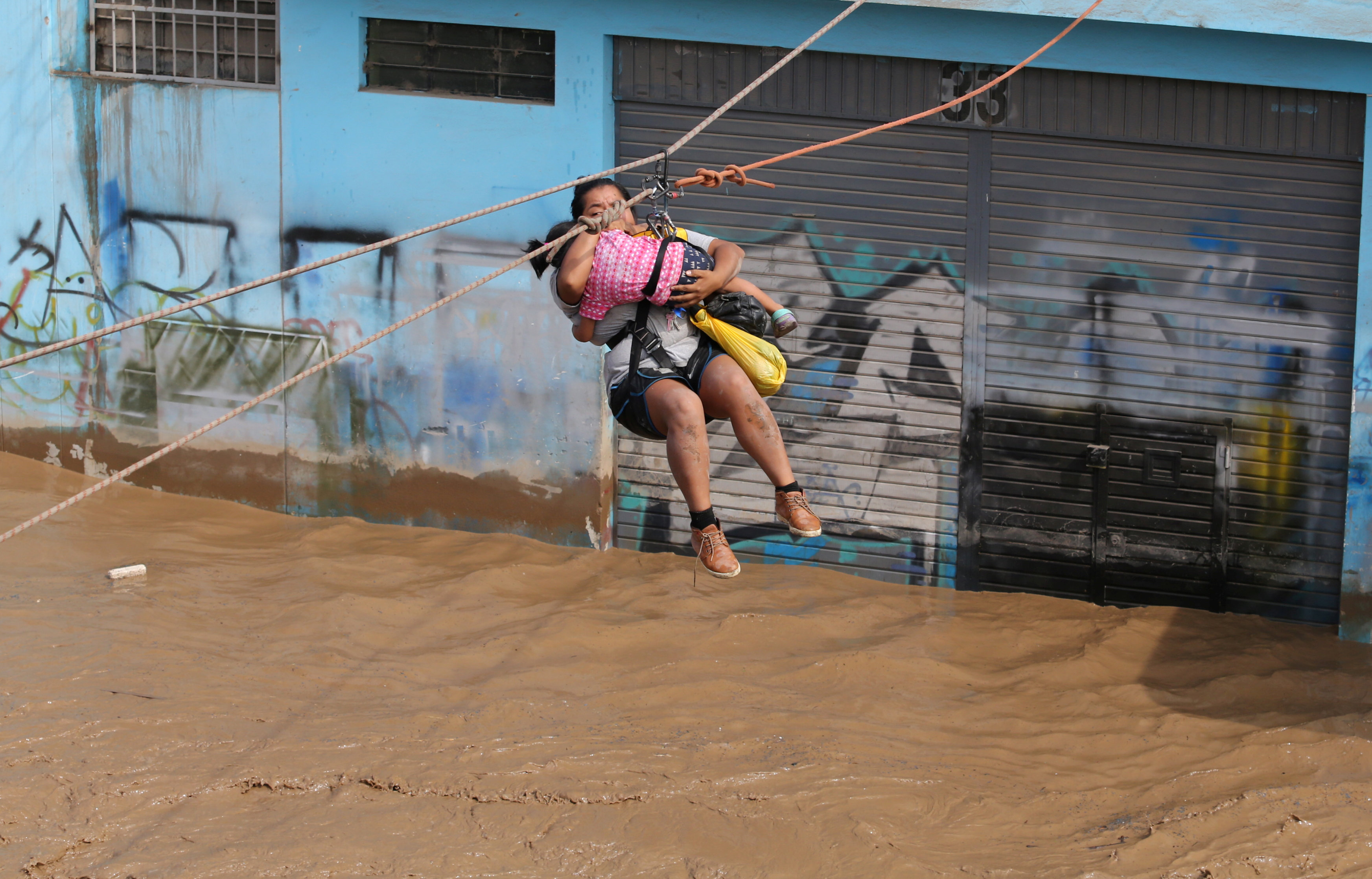
A woman and a child are evacuated with a zip line after the Huayco river overflooded its banks sending torrents of mud and water rushing through the streets in Huachipa, Peru, March 17, 2017. REUTERS/Guadalupe Pardo

A woman and a child are evacuated with a zip line after the Huayco river overflooded its banks sending torrents of mud and water rushing through the streets in Huachipa, Peru, March 17, 2017. REUTERS/Guadalupe Pardo

Peru is bracing itself for another month of flooding.

A local El Nino phenomenon, the warming of surface sea temperatures in the Pacific, will likely continue along Peru’s northern coast at least through April, said Dimitri Gutierrez, a scientist with Peru’s El Nino committee.

Local El Ninos in Peru tend to be followed by the global El Nino phenomenon, which can trigger flooding and droughts in different countries, said Gutierrez.

The U.S. weather agency has put the chances of an El Nino developing in the second half of 2017 at 50-55 percent.

While precipitation in Peru has not exceeded the powerful El Nino of 1998, more rain is falling in shorter periods of time – rapidly filling streets and rivers, said Jorge Chavez, a general tasked with coordinating the government’s response.

“We’ve never seen anything like this before,” said Chavez. “From one moment to the next, sea temperatures rose and winds that keep precipitation from reaching land subsided.”

Some scientists have said climate change will make El Ninos more frequent and intense.

A woman is assisted while crossing a flooded street after the Huayco river overflooded its banks sending torrents of mud and water rushing through the streets in Huachipa, Peru, March 17, 2017. REUTERS/Guadalupe Pardo

A woman is assisted while crossing a flooded street after the Huayco river overflooded its banks sending torrents of mud and water rushing through the streets in Huachipa, Peru, March 17, 2017. REUTERS/Guadalupe Pardo

In Peru, apocalyptic scenes recorded on cellphones and shared on social media have broadened the sense of chaos.

A woman caked in mud pulled herself from under a debris-filled river earlier this week after a mudslide rushed through a valley where she was tending to crops.

Bridges have collapsed as rivers have breached their banks, and cows and pigs have turned up on beaches after being carried away by rivers.

“There’s no need to panic, the government knows what it’s doing,” President Pedro Pablo Kuczynski said in a televised event, urging people to stay clear of rivers.

In Lima, the capital, classes have been suspended and running water has been restricted after treatment systems were clogged – prompting a rush on bottled water that produced shortages at some supermarkets.

The vast majority of people affected by the extreme weather are poor, including many who built makeshift homes on floodplains that had been dry for 20 years, said Chavez.

“There’s no electricity, no drinking water…no transit because streets are flooded,” said Valentin Fernandez, mayor of the town Nuevo Chimbote.

Chavez said Peru must rethink its infrastructure to prepare for the potential “tropicalization” of the northern desert coast, which some climate models have forecast as temperatures rise.

“We need more and better bridges, we need highways and cities with drainage systems,” said Chavez. “We can’t count on nature being predictable.”

(Reporting by Mitra Taj; Additional reporting by Reuters TV; Editing by Leslie Adler)

Late-season snowstorm weakens in the Northeast

Residents clear their cars and street of snow in Weehawken, New Jersey, as the One World Trade Center and lower Manhattan are seen after a snowstorm in New York, U.S. March 14, 2017. REUTERS/Eduardo Munoz

(Reuters) – A late-season snowstorm that swept the mid-Atlantic and northeastern United States began to weaken on Wednesday after killing six people, grounding thousands of flights and closing schools.

Still, millions of people on the East Coast faced temperatures 10 to 25 degrees below average, wind gusts of 30 mph (50 kph) and slick roads and sidewalks as they returned to work and classes on Wednesday.

“Residual snow and slush will refreeze early this morning, resulting in hazardous conditions,” the National Weather Service said in an advisory, urging those who ventured out early to use extra caution.

The rare mid-March “nor’easter” was tapering off over upstate New York and northern New England after dumping as much as a foot (30 cm) of snow with gale-force winds throughout the region on Tuesday, the weather service said.

As life returns to normal for many, students in Boston Public Schools will have the day off while the city and surrounding area continue to dig out from heavy snowfall.

Amtrak said its trains would operate on a modified schedule between New York City and Boston and between New York City and Albany on Wednesday.

On Tuesday, snow fell from the lower Great Lakes and central Appalachians to the Eastern Seaboard and as far south as North Carolina.

Some cities, such as Washington, D.C., and New York, got just a few inches of snow, far less than the anticipated amounts that forced public officials to close schools, stop commuter trains and warn people to stay indoors on Tuesday.

Governors in New York, New Jersey, Pennsylvania and Virginia declared states of emergency before the storm.

“Mother Nature is an unpredictable lady sometimes,” New York Governor Andrew Cuomo told a news conference on Tuesday. “She was unpredictable today.” More than 6,000 commercial airline flights across the United States were canceled for the day, said tracking service FlightAware.com. Utility companies said more than 220,000 homes and businesses were without power at the storm’s peak.

Six weather-related fatalities included the death of a 16-year-old girl in a single-car crash in Gilford, New Hampshire, according to the city police department.

A snowplow driver was killed in Longmeadow, Massachusetts, local police said, and four older people died clearing snow in Milwaukee County, Wisconsin, the local medical examiner said.

The storm capped an unusually mild winter, with otherwise below-normal snowfall on much of the Atlantic coast.

(Reporting by Brendan O’Brien in Milwaukee and Barbara Goldberg in New York; Editing by Lisa Von Ahn)

Blizzard blows into northeast U.S.; flights canceled, schools shut

Cars are covered in snow in a general parking lot during the snowstorm at O'Hare International Airport in Chicago, Illinois, U.S., March 13, 2017. Some Chicagoland areas received up to 5 inches of snow, and more than 400 flights were cancelled at O'Hare. REUTERS/Kamil Krzaczynski

By Daniel Trotta and Scott Malone

NEW YORK/BOSTON (Reuters) – Snow piled up rapidly in parts of the northeastern United States on Tuesday as a blizzard began blowing in, with residents being advised to stay at home, airlines grounding flights and schools canceling classes.

The National Weather Service (NWS) warned some 50 million people from Pennsylvania to Maine of a “rapidly intensifying nor’easter” that was unusual for so late in the winter. Some could expect to find themselves surrounded by up to 2 feet (60 cm) of snow by early Wednesday, the federal agency predicted.

Governors in New York, New Jersey, Pennsylvania and Virginia declared states of emergency.

New York City was expected to escape the worst of it after the NWS withdrew its blizzard warning for the city on Tuesday morning, replacing it with a mere “winter weather advisory.” The service sharply reduced its snowfall forecast for the city to between 4 and 8 inches (10 and 20 cm).

Still, city life already was disrupted with many New Yorkers already planning to stay home with hard-won groceries picked up from crowded stores the night before.

New York Governor Andrew Cuomo suspended above-ground portions of the city’s subway service and said the Metro-North commuter service to the suburbs would shut down at noon. Transit officials warned that more bus and train routes might be suspended throughout the day.

“Normally, with the geography of New York, we normally have it on the east side or the west side. But this is statewide,” Cuomo told MSNBC in an interview.

“We’ve been through this a number of times so we’re prepared for it. Airports are basically closed … Government is basically closed, schools are basically closed, so there’s no real reason to be on the roads and we made that clear yesterday.”

Some 2,000 members of the National Guard and 5,000 plows were deployed across the state, Cuomo said.

Workers clear frozen precipitation from a walkway at the U.S. Capitol in Washington, U.S., March 14, 2017. REUTERS/Jonathan Ernst

Workers clear frozen precipitation from a walkway at the U.S. Capitol in Washington, U.S., March 14, 2017. REUTERS/Jonathan Ernst

AIR TRAFFIC SNARLED

Airlines canceled about 5,500 flights across the United States, according to tracking service FlightAware.com. The airports with the most cancellations were Newark in New Jersey, LaGuardia in New York and Boston Logan International Airport.

American Airlines <AAL.O> canceled all flights into New York’s three airports – Newark, LaGuardia and John F. Kennedy International Airport – and JetBlue Airways <JBLU.O> reported extensive cancellations.

Delta Air Lines <DAL.N> canceled 800 flights for Tuesday for New York, Boston and other northeast airports. United Airlines <UAL.N> said it would have no operations at Newark or LaGuardia.

“We’re keeping a close eye on things and depending on how things go, will plan to ramp back up Wednesday morning,” United said in a statement.

New York City public schools – the largest U.S. school system – canceled classes on Tuesday as did schools in the Washington, D.C., area, Boston, Philadelphia and northern New Jersey.

Federal agencies in Washington said they were opening three hours later than normal on Tuesday.

The storm comes near the end of an unusually mild winter along much of the East Coast, with below-normal snowfalls in cities such as New York City and Washington.

Boston was braced for up to a foot of snow, which forecasters warned would fall quickly during the storm’s peak. The double-murder trial in Boston of former New England Patriots star Aaron Hernandez was suspended for the day because of the weather.

Washington, a city that functions badly with even small amounts of snow, was expecting 5 inches (13 cm) and twice that in outlying areas.

Snow fall was to be heavy at times with as much as 4 inches an hour expected to fall with winds reaching up to 60 mph (100 kph) in parts of the northeast, the National Weather Service warned.

Coastal flood warnings were also in effect for several parts of the region as a storm surge is expected during high tide on Tuesday, the weather service said.

German Chancellor Angela Merkel, who was due to meet President Donald Trump in Washington on Tuesday, postponed her trip until Friday, the White House said.

Shelves are seen scarce with bread at a Trader Joe's grocery store ahead of a fast-moving winter storm expected to hit the northeastern United States, in the borough of Manhattan in New York, U.S., March 13, 2017. REUTERS/Shannon Stapleton

Shelves are seen scarce with bread at a Trader Joe’s grocery store ahead of a fast-moving winter storm expected to hit the northeastern United States, in the borough of Manhattan in New York, U.S., March 13, 2017. REUTERS/Shannon Stapleton

(Additional reporting by Brendan O’Brien in Milwaukee, Laila Kearney and Jonathan Allen in New York and Scott Malone in Boston; Editing by Louise Ireland and Bill Trott)