Wildfires kill 17 in California wine country

Wildfires kill 17 in California wine country

By Marc Vartabedian

SANTA ROSA, Calif. (Reuters) – Firefighters battling wildfires in California’s wine country face the prospect of new outbreaks when dry, windy conditions return on Wednesday to an area where at least 17 people have been killed and 2,000 homes and businesses destroyed in blazes.

Gusts of up to 50 mph (80 kph) and 10 percent humidity are forecast for later on Wednesday and into Thursday for the region where 17 fires have forced 20,000 people to flee their homes, fire officials said.

“The potential for new fires that could grow exponentially as these fires did in such a short time period is there,” said Lynne Tolmachoff, spokeswoman for California Department of Forestry and Fire Protection.

The weather gave firefighters a reprieve on Tuesday as cooler temperatures, lower winds and coastal fog allowed them to make headway against the fires that had burned 115,000 acres.

Some evacuations in Nevada and Yuba counties in western California were lifted on Tuesday while other evacuations to the east in Sonoma and Napa counties, where more than 50,000 acres burned, were expanded, Tolmachoff said.

Some 155 people were still missing in Sonoma County, although 45 others had been found and some of those unaccounted for may be due to confusion surrounding evacuations.

The city of Santa Rosa was particularly hard hit by the so-called Tubbs Fire, which damaged a Hilton hotel and destroyed a mobile home park.

Irene Fonzeca and her husband Luis were spending their second night in shelter on Tuesday after the couple woke up to raging fire nearby that was being blown toward their home on Monday.

The sound of fiery trees crashing down was terrifying, Luis said.

“We have no idea what’s there or if there’s anything to go back to,” Irene Fonzeca said outside the shelter holding a breathing mask as smoke and light ash blanketed downtown Santa Rosa.

In the shelter, emotions were raw, Irene Fonzeca said.

“People are crying hugging helping each other. It’s devastating,” she said.

In Napa County, the dead included 100-year-old Charles Rippey and his wife, Sarah, 98, according to the county sheriff’s office. The couple were married for 75 years, a CBS affiliate in San Francisco reported, citing their son, Mike.

Charles Rippey’s body was found outside where her bedroom once stood, he said.

“He was trying to get from his room to her room,” Mike Rippey said. “He never made it. Even if he had gotten there, he wouldn’t have been able to get her out … And there is no way he would have left.”

Napa Valley Vintners, a trade group, said it was too early to assess the economic impact of the fires. At least four wineries had suffered “total or very significant losses,” and at least nine reported damage, the group said.

California Governor Jerry Brown declared a state of emergency in several northern counties where fires where burning and in Orange County in Southern California, where the so-called Canyon Fire 2 destroyed 14 structures and damaged 22 and forced the evacuation of 5,000 people, fire spokesman Thanh Nguyen said.

(Additional reporting by Alex Dobuzinskis in Los Angeles, Keith Coffman in Denver, Brendan O’Brien in Milwaukee and Jonathan Allen in New York; Editing by Richard Balmforth)

Abandoned by tourists, Bali town counts cost of Indonesia volcano

Jemeluk beach is seen some 15 km away from Mount Agung, a volcano on the highest alert level, in Amed on the resort island of Bali, Indonesia October 2, 2017. REUTERS/Darren Whiteside

By Nyimas Laula and Darren Whiteside

AMED, Indonesia (Reuters) – A Balinese town once bustling with holidaymakers has almost emptied of tourists after warnings that nearby Mount Agung volcano could erupt at any time – a snapshot of the growing cost the rumbling volcano poses to Indonesia’s economy.

Business has slumped at many hotels, dive resorts and restaurants in towns around the volcano since authorities issue the highest alert level for Mount Agung last month.

An owner of a dive center in Amed, around 15 km (9 miles) from the volcano and just outside the official “danger zone”, said many of her guests had canceled.

“If (the situation) lasts for nine months or more… then we have no choice but to close down because we will have no money left to operate and pay the staff,” said Helene Rabate, a Spaniard who runs the center.

Cafes and restaurants were largely empty and few visitors were seen at the usually crowded dive centers of this seaside town.

The last time Agung erupted was in 1963, when more than 1,000 people were killed. Since then, tourism has transformed towns like Amed from sleepy fishing and agricultural villages.

Restaurant owner Wayan Widarti has seen a dramatic drop in customers.

“It could be worse than when the Bali bombing happened because there’s uncertainty on when (the eruption) is going to happen and how long we wait,” she said, referring to the 2002 nightclub bombing that killed 202 people and prompted a slump in visitors to the holiday island.

Bali, famous for its surf, beaches and temples, attracted nearly 5 million visitors last year – more than half the total number of foreign tourists to Indonesia.

Tourism, a cornerstone of Bali’s economy, is Indonesia’s fourth-biggest earner of foreign currency after natural resources like coal and palm oil.

Indonesian policy makers have been seeking to boost an economy whose growth rate has been stuck at around 5 percent for the last few years, so any protracted damage to tourism will be particularly unwelcome.

Indonesian officials have said Bali remains safe for tourism, but there have been cancellations even in areas further away from the volcano amid concerns that ash clouds could disrupt air connections.

Some tourists are still in the area at a safe distance from the volcano.

“We plan to… just follow security instructions… and take a fast boat to escape if there is an eruption,” said Arlin Shiu, a woman from Hong Kong who was traveling with a friend.

Disaster management authorities have imposed an exclusion zone of up to 12 km, prompting more than 140,000 residents to flee to neighboring villages.

“For people who live in safe zones, there is no reason to evacuate,” Bali governor I Made Mangku Pastika said, adding that makeshift evacuation centers were straining under the weight of thousands of extra evacuees.


(Writing by Kanupriya Kapoor; Editing by Ed Davies)


Hundreds leave homes near dangerously crumbling Puerto Rico dam

Local residents look at the flooded houses close to the dam of the Guajataca lake. REUTERS/Carlos Garcia Rawlins

By Dave Graham and Robin Respaut

SAN JUAN (Reuters) – Most people living near a crumbling dam in storm-battered Puerto Rico have been moved to safety, Governor Ricardo Rossello said on Monday, as he urged the U.S. Congress to fund an aid package to avert a humanitarian crisis after Hurricane Maria.

Most of the Caribbean island, a U.S. territory with a population of 3.4 million, is still without electricity five days after Maria swept ashore with ferocious winds and torrential rains, the most powerful hurricane to hit Puerto Rico for nearly a century.

There have been growing concerns for some 70,000 people who live in the river valley below the Guajataca Dam in the island’s northwest, where cracks were seen appearing on Friday in the 88-year-old earthen structure.

An aerial view shows the damage to the Guajataca dam. REUTERS/Alvin Baez

An aerial view shows the damage to the Guajataca dam. REUTERS/Alvin Baez

Rossello said he was working on the assumption that the dam would collapse. “I’d rather be wrong on that front than doing nothing and having that fail and costing people lives,” he said in an interview with CNN.

“Some of the dam has fallen apart and now we’re making sure that we can assess if the other part is going to fall down as well. … Most of the people in the near vicinity have evacuated.”

It was unclear if the governor was saying that most of the 70,000 valley inhabitants had left the area, or only the several hundred people living in the small towns closest to the dam. About 320 people from those towns have moved to safety, according to local media.

The fear of a potentially catastrophic dam break added to the difficulties facing disaster relief authorities after Maria, which was the second major hurricane to strike Caribbean this month and which killed at least 29 people in the region.

At least 10 of those who died were in Puerto Rico, including several people who drowned or were hit by flying debris, and three elderly sisters who died in a mudslide.

Many structures on the island, including hospitals, remain badly damaged and flooded. Clean drinking water is hard to find in some areas. Very few planes have been able to land or take off from damaged airports.

After Maria caused widespread flooding, the National Weather Service warned of further flash floods in some western parts of the island on Monday as thunderstorms moved in.

The hurricane hit at a time when Puerto Rico was already battling economic crisis. [nL2N1M31LR]

Rossello said on Monday that before the storms struck he had been embarking on an aggressive fiscal agenda that included more than $1.5 billion in cuts.

“This is a game changer,” the governor told CNN. “This is a completely different set of circumstances. This needs to be taken into consideration otherwise there will be a humanitarian crisis.”

In Washington, U.S. House of Representatives Speaker Paul Ryan said Congress was working with President Donald Trump’s administration to make sure the necessary assistance reaches Puerto Rico.

“Our fellow citizens in Puerto Rico remain in our prayers as we make sure they have what they need,” Ryan said in a statement.

Local residents react while they look at the water flowing over the road at the dam of the Guajataca lake.

Local residents react while they look at the water flowing over the road at the dam of the Guajataca lake.
REUTERS/Carlos Garcia Rawlins

Maria continued to weaken and would likely be downgraded from a hurricane to a tropical storm by Tuesday night, the National Hurricane Center said. As of 11 a.m. ET (1500 GMT) on Monday, it was about 315 miles (505 km) south-southeast of Cape Hatteras, North Carolina, heading slowly north, the center said.

The storm was unlikely to hit the continental United States directly, but a tropical storm warning was in effect for much of the North Carolina coast. Officials issued a mandatory evacuation order for visitors to Ocracoke Island in the Outer Banks, beginning at 5 a.m. ET (0900 GMT) on Monday.


(Reporting by Dave Graham and Robin Respaut; Additional reporting by Jonathan Allen and Peter Szekely in New York and Doina Chiacu in Washington; Editing by Daniel Wallis and Frances Kerry)


Houston crippled by catastrophic flooding with more rain on the way

Flooded downtown is seen from a high rise along Buffalo Bayou after Hurricane Harvey inundated the Texas Gulf coast with rain causing widespread flooding, in Houston, Texas, U.S. August 27, 2017 in this picture obtained from social media.

By Gary McWilliams and Ruthy Munoz

HOUSTON (Reuters) – Houston is facing worsening historic flooding in the coming days as Tropical Storm Harvey dumps more rain on the city, swelling rivers to record levels and forcing federal engineers on Monday to release water from area reservoirs in hopes of controlling the rushing currents.

Harvey, the most powerful hurricane to strike Texas in more than 50 years, first hit land late on Friday and has killed at least two people. It has since lingered around Texas’ Gulf Coast, where it is forecast to remain for several more days, drenching parts of the region with a year’s worth of rain in the span of a week.

Schools, airports and office buildings in the nation’s fourth largest city were ordered shut on Monday as scores of roads turned into rivers and chest-high water filled neighborhoods in the low-lying city that is home to about 2.3 million people. The area’s vital petrochemcial industry also was crippled.

Torrential rain also hit areas more than 150 miles (240 km) away, swelling rivers upstream and causing a surge that was heading toward the Houston area, where numerous rivers and streams already have been breached.

More flooding is expected as water levels continue to rise, putting more residents at risk. More than 30,000 people are expected to be placed temporarily in shelters, FEMA Administrator Brock Long said at a news conference on Monday. The National Weather Service said the worst of floods are expected Wednesday and Thursday, although there is still uncertainty over the storm’s path.


RESERVOIR RELEASES

The U.S. Army Corps of Engineers said Monday that it was releasing water from two nearby reservoirs into Buffalo Bayou, the primary body of water running through Houston.

“If we don’t begin releasing now, the volume of uncontrolled water around the dams will be higher and have a greater impact on the surrounding communities,” said Colonel Lars Zetterstrom, Galveston district commander of the Corps.

The Harris County Flood Control District said it expected the release to start flooding homes around the Addicks and Barker reservoirs on Monday morning.

Authorities ordered more than 50,000 people to leave parts of Fort Bend County, about 35 miles (55 km) southwest of Houston, as the Brazos River was set to crest at a record high of 59 feet (18 m) this week, 14 feet above its flood stage.

Brazos County Judge Robert Hebert told reporters the forecast crest represented a high not seen in at least 800 years.

“What we’re seeing is the most devastating flood event in Houston’s recorded history,” said Steve Bowen, chief meteorologist at reinsurance company Aon Benfield.

Harvey is expected to produce an additional 15 to 25 inches (38 to 63 cm) of rain through Friday in the upper Texas coast and into southwestern Louisiana, the National Hurricane Center said.

By the end of the week in some Texas coastal areas the total precipitation could reach 50 inches (127 cm), which is the average rainfall for an entire year, forecasters said. Nearly 24 inches fell in 24 hours in Baytown, a city with major refineries about 30 miles east of Houston, the weather service said early on Monday.

Dallas, 240 miles (386 km) north of Houston, will set up a “mega shelter” at its convention center to house 5,000 evacuees, the city said in a statement.


TRUMP VISIT

U.S. President Donald Trump plans to go to Texas on Tuesday to survey the storm damage, a White House spokeswoman said on Sunday. On Monday he approved an emergency declaration for Louisiana.

Trump, facing the first big U.S. natural disaster since he took office in January, had signed a disaster proclamation for Texas on Friday, triggering federal relief efforts. Texas Governor Greg Abbott said on Sunday he planned to add 1,000 more National Guard personnel to the flood battle.

Almost half of the U.S. refining capacity is in the Gulf region. Shutdowns extended across the coast, including Exxon Mobil’s Baytown refinery. More than 2.3 million barrels of capacity were offline as of Monday morning, representing 13 percent of daily U.S. production.

Gasoline futures rose more than 4 percent to two-year highs on Monday morning. The outages will limit the availability of U.S. gasoline and other refined products for global consumers and push prices higher, analysts said.

The center of Harvey was 90 miles (148 km) southwest of Houston on Monday morning and forecast to arc slowly toward the city through Wednesday.

Thousands of people were rescued on Sunday by Harris County Sheriff’s Office, U.S. Coast Guard and Houston police as residents brought boats to staging centers and helicopters were deployed to save others stranded.

Federal authorities predicted it would take years to repair the damage from Harvey. The expected rain conjured memories of Tropical Storm Allison, which lingered for days over South Texas in 2001, flooding 70,000 homes and causing $9 billion in damage.

Damages are not likely to be as extensive as Katrina in 2005, which killed 1,800 people in and around New Orleans, or Sandy, which hit New York in 2012, said a spokeswoman for Hannover Re, one of the world’s largest reinsurers. Those caused $80 billion and $36 billion in insured losses, respectively.

All Houston port facilities will be closed on Monday because of the weather threat, a port spokeswoman said.

More than 247,000 customers in the Houston area were without power on Monday morning, utilities CenterPoint Energy, AEP Texas and TNMP said. CenterPoint warned, though, it could not update its figures due to limited access caused by flooding.

Jose Rengel, 47, a construction worker who lives in Galveston, helped rescue efforts in Dickinson, southeast of Houston, where he saw water cresting the tops of cars.

“I am blessed that not much has happened to me but these people lost everything,” he said.

“And it keeps raining. The water has nowhere to go.”


(Additional reporting by Brian Thevenot in Rockport, Kevin Drawbaugh, Valerie Volcovici and Jeff Mason in Washington, DC, Chris Michaud and Dion Rabouin in New York, Erwin Seba, Marianna Parraga, Nick Oxford and Ernest Scheyder in Houston; Writing by Jon Herskovitz and David Gaffen; Editing by Lisa Von Ahn and Bill Trott)


Montana wildfire triggers hundreds of evacuations

By Keith Coffman

(Reuters) – A lightning-sparked wildfire burning for more than a month in western Montana has flared anew, prompting the evacuation of nearly 750 homes on Thursday as firefighters braced for more hot and windy weather forecast for the weekend, authorities said.

The so-called Lolo Peak fire, burning about 12 miles south of Missoula, has scorched more than 15,000 acres of timber since it erupted in mid-July, as tinder-dry conditions challenged efforts to contain the blaze.

“When the winds kicked up last Sunday, it made a run of one and a half miles in an hour and has been growing since,” U.S. Forest Service spokesman James Stone said.

Erratic winds pushed flames close to housing subdivisions in two counties on Thursday, prompting mandatory evacuations of residents from 743 homes, said Jordan Koppen, a spokesman for the fire management command.

Fire retardant drops from helicopters and fixed-wing aircraft have been deployed to douse the flames in an effort to assist some 500 firefighters on the scene.

No property losses have been reported, but a 29-year-old member of an elite “hotshots” firefighting crew from California was killed this month when a falling tree struck him.

Koppen said weather forecasters have issued red-flag warnings for the area on Friday, and he expects the burned acreage to increase when the fire is mapped again Thursday night.

The northern Rocky Mountain region has been in the grips of a prolonged drought, and this year wildfires have blackened 393,000 acres in Montana and parts of neighboring Idaho, Stone said.

In Oregon on Thursday, Governor Kate Brown authorized the state’s fire marshal to mobilize additional resources to aid local firefighting efforts near the Cascade town of Sisters, where a wildfire threatened more than 400 structures. An estimated 1,200 residents of the area were advised to stand by for possible evacuation notices.

(Reporting by Keith Coffman in Denver; Editing by Steve Gorman and Leslie Adler)

Central California wildfire nearly 50 percent contained as hot, dry conditions persist

A USFS bulldozer cuts a line through vegetation to create a safety line below West Camino Cielo while fighting the Whittier Fire near Santa Barbara, California, U.S. July 15, 2017.

(Reuters) – A damaging wildfire burning on California’s scenic central coast was expected to continue burning into Monday, after fire fighters made progress on Sunday in containing the blaze which has destroyed 16 homes.

By Sunday evening the so-called Whittier Fire burning near Santa Barbara was 49 percent contained, an improvement from earlier in the day and nearing Friday’s 50 percent containment, the California Department of Forestry and Fire Protection, or Cal Fire, said.

Forecasters said that while temperatures and humidity trends would remain fairly constant, some cooling was expected due to onshore winds along the fire’s coastal sections.

California Gov. Jerry Brown declared a state of emergency in Santa Barbara County due to the Whittier and Alamo fires burning there.

Cal Fire bumped up the number of dwellings to 16 destroyed and one damaged by the Whittier fire after getting a closer look at the affected area. Most of them were burned in the early hours of the fire, which started on July 8.

The fire grew on Friday evening when so-called “sundowner” offshore winds picked up, pushing it into dry brush that has not burned since 1955, Cal Fire said.

By Sunday the conflagration had burned 18,015 acres (7,290 hectares) along California’s scenic central coast, up from 17,364 acres (7,027 hectares) on Saturday.

An evacuation shelter is open at a high school in Goleta, near Santa Barbara.

In the area of the fire, Sunday temperatures pushed 100 degrees Fahrenheit (38 Celsius) with humidity low at about 10 to 15 percent.

The Whittier Fire is among more than 50 large, active wildfires burning across the U.S. West as forecasters warned that hot, dry conditions could persist, creating tinderbox conditions.

Flames have charred more than twice as much land in California so far in 2017 compared with the same time last year, according to Cal Fire.


(Reporting by Bernie Woodall in Fort Lauderdale, Florida and Chris Michaud in New York; Editing by Frank McGurty, Sandra Maler and Jacqueline Wong)


Wildfire in California canyons spreads overnight

Smoke is illuminated by the Whittier wildfire near Santa Ynez, California, U.S. July 8, 2017. Picture taken July 8, 2017.

(Reuters) – A fast-moving wildfire burned overnight through thousands more acres of steep terrain near California’s central coast, officials said on Sunday, as high temperatures and parched vegetation fueled dozens of blazes in the U.S. West and Southwest.

The Alamo Fire has engulfed about 23,900 acres in the area of the border between San Luis Obispo and Santa Barbara counties, a few miles from the city of Santa Maria, according to the California Department of Forestry and Fire Protection, or Cal Fire for short. That was up from 19,000 acres on Saturday evening.

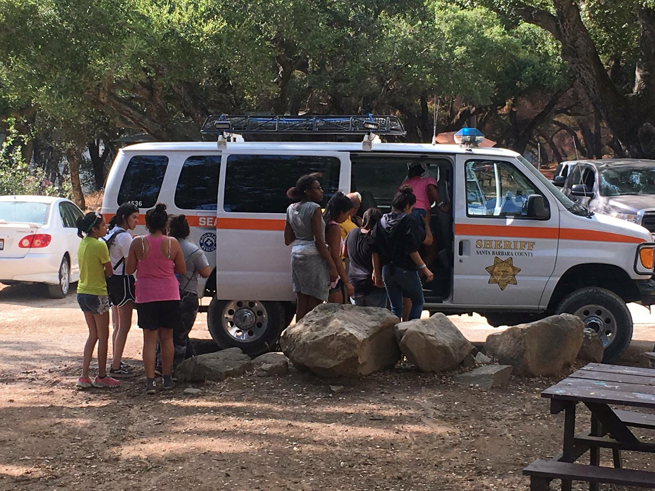
Youths are evacuated by sheriff's deputies from a campground near the Whittier wildfire near Santa Ynez, California,

Youths are evacuated by sheriff’s deputies from a campground near the Whittier wildfire near Santa Ynez, California, U.S. July 9, 2017. Santa Barbara County Sheriff’s Office/Handout via REUTERS.

About 15 percent of the fire had been contained by Sunday evening, Cal Fire tweeted. The fire has so far destroyed one structure and was threatening more than 130 others, Cal Fire said.

On Saturday, hundreds of people were ordered to evacuate the remote canyons affected by the fire. No injuries have been reported. Hundreds of firefighters were trying to stop the fire from reaching wineries to the south and electric transmission lines to the southeast, Santa Barbara County officials said.

The Alamo Fire was one of about 50 large uncontained fires burning in western states, the National Weather Service said on Sunday morning.

Smoke rises from the Alamo fire near Santa Maria, California, U.S. in this July 8, 2017

Smoke rises from the Alamo fire near Santa Maria, California, U.S. in this July 8, 2017 handout photo obtained by Reuters July 9, 2017. San Luis Obispo Fire Department/Handout via REUTERS.

A wave of scorching weather has hit California in recent days. On Saturday, a fire at an electrical power station in Los Angeles left 140,000 residents without power, after a second straight day marked by temperatures that exceeded 90 degrees Fahrenheit (32 Celsius).


(Reporting by Jonathan Allen and Eric M. Johnson; Editing by Chris Reese)


Suspicious truck prompts evacuations at Massachusetts Air Force base

BOSTON (Reuters) – Massachusetts State Police said on Thursday they were investigating a suspicious truck stopped at the gates of Hanscom Air Force Base after an initial screening of the vehicle indicated signs of possibly hazardous material.

Parts of the base were evacuated but no injuries were reported, base officials said in a statement. The incident began at about 9 a.m. EDT (1300 GMT) when base security became concerned about the truck at a gate during a routine inspection.

The State Police bomb squad and a State Police helicopter went to the scene at the base, located about 15 miles (24 km)northwest of Boston.

About 10,000 people, including military staff and civilians, work at the 846-acre (342-hectare) site in Bedford, Massachusetts, which is home to units overseeing acquisitions, cyber security and some nuclear operations.

Live aerial footage showed a large truck with “BigFoot Moving & Storage” emblazoned on the side stopped near the base’s gate with an armored military vehicle parked nearby. Police said they had set up a 1,500-foot (457-meter) perimeter around the truck. ”

A person who answered the phone at the moving company and declined to give her name said that she was aware of the truck’s presence at the base but had no details as to what was in it.

The nearby L.G. Hanscom Field airport, which caters to small planes, remained open, the Bedford Police Department said on Twitter.

(Reporting by Scott Malone; Editing by Jeffrey Benkoe and Gabriella Borter)

Fire in Okefenokee wildlife refuge forces evacuations in Georgia

The West Mims fire burns in the Okefenokee National Wildlife Refuge, Georgia,

By Bernie Woodall

(Reuters) – A wildfire in Georgia’s Okefenokee National Wildlife Refuge has forced dozens of nearby residents to leave their homes, authorities said on Sunday, adding the blaze might not be fully contained for months.

About 130,000 acres (52,600 hectares), or almost a third of the refuge, have already burned, said Melanie Banton, a spokeswoman for firefighters and park officials battling the West Mims Fire, which began on April 6.

The refuge, which is popular with tourists, is home to black bears, alligators and sandhill cranes.

The fire was only 12 percent contained as of Sunday afternoon and more than 500 people were fighting the blaze, according to fire information website InciWeb.

Most of the fire was within the refuge, which straddles Georgia’s southeast border with Florida, but it is encroaching on private land. No injuries have been reported.

A shelter has been set up in a gymnasium in Folkston, Georgia, for 79 residents in the tiny town of St. George, Georgia, who were told on Saturday to evacuate, Banton said.

“First Responders are NOT coming door to door, because they are fighting this approaching fire to try to save your homes,” the refuge said on its Facebook page.

Shifting winds have helped spread the fire, Banton said, adding it could take until November before the blaze is fully contained.

Smoke is seen during sunset as the West Mims fire burns in the Okefenokee National Wildlife Refuge, Georgia,

Smoke is seen during sunset as the West Mims fire burns in the Okefenokee National Wildlife Refuge, Georgia, U.S. in a photo released April 29, 2017. Fish and Wildlife Service/Mark Davis/Handout via REUTERS

Winds gusts of up to 25 miles per hour (40 kph) and low humidity boosted chances of the fire’s spreading on Sunday, according to a statement issued by forestry and firefighting officials.

“Anything that can burn will burn if a hot ember falls,” the statement said.

The fire burned into Florida last month and may advance into that state again, officials said on Sunday.

While much of the wildlife refuge is marshland and swamp, parts of it are prairie and wooded land.

Six years ago, a wildfire burned more than 300,000 acres (121,400 hectares) of the 407,000-acre (164,700-hectare) refuge, said Mark Davis, a spokesman for the U.S. Fish and Wildlife Service, which runs the refuge.

(Reporting by Bernie Woodall in Fort Lauderdale, Fla.; Additional reporting by Jon Herskovitz in Austin, Texas; Editing by Paul Simao and Peter Cooney)

Spillway on California dam in danger of collapse, evacuations ordered

65,000 cfs of water flow through a damaged spillway on the Oroville Dam in Oroville, California, U.S.

By Dan Whitcomb

(Reuters) – Residents below the tallest dam in the United States, near Oroville in Northern California, were urgently ordered to evacuate on Sunday as a spillway appeared in danger of imminent collapse.

The abrupt evacuation orders came as authorities determined that the auxiliary spillway on the Lake Oroville Dam could give way at any time, unleashing floodwaters onto rural communities along the Feather River. “Immediate evacuation from the low levels of Oroville and areas downstream is ordered,” the Butte County sheriff said in a statement posted on social media. “This is NOT A Drill.”

The Oroville dam is nearly full after weeks of heavy rains and snow brought relief to the state after some four years of devastating drought.

The California Department of Water Resources said on Twitter at about 4:30 p.m. PST that the spillway next to the dam was “predicted to fail within the next hour.”

However it was still standing nearly three hours later as the Water Resources department said crews would use helicopters to drop rocks to fill a gouge in the spillway. Authorities were also releasing water to lower the lake’s level.

The Yuba County Office of Emergency Services urged evacuees to travel only to the east, south or west. “DO NOT TRAVEL NORTH TOWARD OROVILLE,” the department said on Twitter.

Evacuation centers were set up at a fairgrounds in Chico, California, about 20 miles northwest of Oroville, but roads leading out of the area were jammed as residents sought to drive out of the flood zone.

It was not clear how many residents were affected by the evacuation order.

State authorities and engineers on Thursday began carefully releasing water from the Lake Oroville Dam some 65 miles (105 km) north of Sacramento after noticing that large chunks of concrete were missing from a spillway.

Water levels were less than 7 feet (2 meters) from the top of the dam on Friday.

California Governor Jerry Brown asked the Federal Emergency Management Agency on Friday to declare a major disaster due to flooding and mudslides brought on by the storms.

The earthfill dam is just upstream and east of Oroville, a city of more than 16,000 people.

At 770 feet (230 meters) high, the structure, built between 1962 and 1968, is the tallest dam in the United States, besting the famed Hoover Dam by more than 40 feet (12 meters).

(Reporting by Dan Whitcomb in Los Angeles; Editing by Peter Cooney and Mary Milliken)